Charikar facts for kids
Quick facts for kids
Imam Abu Hanifa
امام ابو حنیفه
Charikar
Imam Azam |
|
|---|---|
|
City
|
|

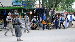
A street in Charikar during the War in Afghanistan, 2007
|
|
| Country | |
| Province | Parwan Province |
| District | Charikar District |
| Elevation | 1,600 m (5,200 ft) |
| Population
(2015)
|
|
| • City | 96,093 |
| • Urban | 96,039 |
| Time zone | UTC+4:30 |
Charikar (Persian: چاریکار), officially renamed to Imam Abu Hanifa (Persian: امام ابو حنیفه) or Imam Azam (Persian: امام اعظم, Persian pronunciation: [ɪˈmɑːm azam]), is the main town of the Koh Daman Valley. It is the capital of Charikar District, and the capital of Parwan Province in northern Afghanistan. It has a population of around 171,200, which is majority Tajik populated. The town was officially renamed in December 2022 by the Taliban to honor the Sunni Muslim theologian and jurist Abu Hanifa, who is also sometimes called Imam Azam ("The Great Imam") and was the founder of the Hanafi school of Islamic law.
The city lies on the Afghan Ring Road, 69 kilometres (43 mi) from Kabul along the route to the northern provinces. Travelers would pass the city when traveling to Mazar-i-Sharif, Kunduz or Puli Khumri. Despite the proximity to Kabul, slightly more than half of the land is not built-up. Of the built-up land, almost equal parts are residential (37%) and vacant plots (32%), with a grid network of road coverage amounting to 19% of built-up land area, as of 2015[update]. The city is at the gateway to the Panjshir Valley, where the Shamali plains meet the foothills of the Hindu Kush, and is known for its pottery and high-quality grapes.
As of 2015[update], the city has a total population of 96,039 people and 10,671 dwellings. It has four police districts (nahias) and a total land area of 3,025 hectares (11.68 sq mi).
History
In 1221, the Battle of Parvan was fought near Charikar, in which Jalal ud-Din with an army of 30,000 with 100,000 auxiliaries defeated a column of 30,000 men of the invading Mongol army to give part of his army enough time to escape into the northern Punjab, and avoid the immediate consequences of the fall of the Khwarezmid Empire.
At the beginning of the 19th century, Charikar became a flourishing commercial town of several thousand inhabitants. Charikar was the location of major battle during the First Anglo-Afghan War. In 1841 a British garrison was massacred by Afghans led by Mir Masjidi Khan, and the Anglo-Indian army officer Major Eldred Pottinger was badly wounded.
During the Soviet–Afghan War (1979–1989), the region around Charikar was the scene to some of the fiercest fighting. Some areas around Charikar served as a stronghold of the Liberation Organization of the People of Afghanistan (SAMA). Charikar was at the front line between Ahmad Shah Massoud's Northern Alliance and the Taliban who captured Kabul in 1996. In January 1997 the Taliban took control of Charikar, but Massoud fought back and recaptured it by July. In August 1999 the Taliban launched an offensive and briefly captured Charikar, before Massoud counterattacked and drove them out again.
On 26 August 2020, the city was the site of floods that killed at least 92 people.
Following the Taliban takeover of Afghanistan in 2021, it was announced by the Taliban provincial governor of Parwan province in December 2022 that the name of the city would be changed. One news source said the new name of the town was "Imam Abu Hanifa", while another reported the new name as "Imam Azam". A government official from the former Afghan regime said the renaming was the beginning of an anti-Farsi campaign by the regime.
Climate
Charikar has a humid continental climate (Köppen: Dsa) with hot summers and cold winters. The winter months are much rainier than the summer months. The warmest month of the year is July, with an average temperature of 25.0 °C (77.0 °F). January is the coldest month, with temperatures averaging −2.9 °C (26.8 °F).
| Climate data for Charikar | |||||||||||||
|---|---|---|---|---|---|---|---|---|---|---|---|---|---|
| Month | Jan | Feb | Mar | Apr | May | Jun | Jul | Aug | Sep | Oct | Nov | Dec | Year |
| Mean daily maximum °C (°F) | 3.6 (38.5) |
4.2 (39.6) |
11.0 (51.8) |
18.4 (65.1) |
25.0 (77.0) |
30.0 (86.0) |
33.0 (91.4) |
32.2 (90.0) |
28.0 (82.4) |
21.4 (70.5) |
13.1 (55.6) |
7.2 (45.0) |
18.9 (66.1) |
| Daily mean °C (°F) | −2.9 (26.8) |
−1.8 (28.8) |
4.4 (39.9) |
10.9 (51.6) |
17.0 (62.6) |
21.9 (71.4) |
25.0 (77.0) |
24.3 (75.7) |
20.0 (68.0) |
13.7 (56.7) |
6.2 (43.2) |
0.7 (33.3) |
11.6 (52.9) |
| Mean daily minimum °C (°F) | −9.3 (15.3) |
−7.8 (18.0) |
−2.3 (27.9) |
3.4 (38.1) |
8.9 (48.0) |
13.7 (56.7) |
17.0 (62.6) |
16.3 (61.3) |
12.0 (53.6) |
5.9 (42.6) |
−0.7 (30.7) |
−5.8 (21.6) |
4.3 (39.7) |
| Average precipitation mm (inches) | 50 (2.0) |
72 (2.8) |
73 (2.9) |
51 (2.0) |
23 (0.9) |
6 (0.2) |
2 (0.1) |
1 (0.0) |
3 (0.1) |
9 (0.4) |
20 (0.8) |
29 (1.1) |
339 (13.3) |
| Average relative humidity (%) | 51 | 58 | 57 | 51 | 40 | 29 | 25 | 25 | 26 | 33 | 43 | 45 | 40 |
| Source: Climate-Data.org | |||||||||||||
See also
 In Spanish: Charikar para niños


