Centreville, Alabama facts for kids
Quick facts for kids
Centreville
|
||
|---|---|---|
|
City
|
||

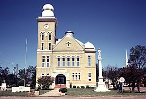
Bibb County Courthouse in Centreville
|
||
|
||

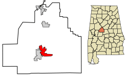
Location of Centreville in Bibb County, Alabama.
|
||
| Country | United States | |
| State | Alabama | |
| County | Bibb | |
| Founded | 1823 | |
| Incorporated | 1832 | |
| Founded by | Sarah Willis Chotard | |
| Area | ||
| • Total | 9.60 sq mi (24.86 km2) | |
| • Land | 9.45 sq mi (24.48 km2) | |
| • Water | 0.15 sq mi (0.38 km2) | |
| Elevation | 253 ft (77 m) | |
| Population
(2020)
|
||
| • Total | 2,800 | |
| • Density | 296.26/sq mi (114.39/km2) | |
| Time zone | UTC-6 (Central (CST)) | |
| • Summer (DST) | UTC-5 (CDT) | |
| ZIP code |
35042
|
|
| Area code(s) | 205, 659 | |
| FIPS code | 01-13672 | |
| GNIS feature ID | 0159359 | |
Centreville is a city and the county seat of Bibb County, Alabama, United States. At the 2020 census, the population was 2,800.
Contents
Geography
According to the U.S. Census Bureau, Centreville has a total area of 9.6 square miles (24.9 km2), of which 9.5 square miles (24.5 km2) are land and 0.15 square miles (0.4 km2), or 1.52%, is water. The city is bordered to the west by the city of Brent by the Cahaba River.
The city is located in the central part of the state along U.S. Route 82, which runs from southeast to northwest to the north of the city, leading southeast 70 mi (110 km) to Montgomery, the state capital, and northwest 35 mi (56 km) to Tuscaloosa. Alabama State Routes 25 and 219 both run through the center of the city from south to north. AL-25 leads northeast 21 mi (34 km) to Montevallo and southwest 38 mi (61 km) to Greensboro. AL-219 leads north 7 mi (11 km) to Alabama State Route 5 north of Brent and south 42 mi (68 km) to Selma.
Climate
The climate in this area is characterized by hot, humid summers and generally mild to cool winters. According to the Köppen Climate Classification system, Centreville has a humid subtropical climate, abbreviated Cfa on climate maps.
Centreville is the site of the highest recorded temperature in the state of Alabama, when on September 6, 1925, the temperature reached 112 °F or 44.4 °C. The data below are for the years 1916 to 1974.
| Climate data for Centreville, Alabama, 1991–2020 normals, extremes 1917–2014 | |||||||||||||
|---|---|---|---|---|---|---|---|---|---|---|---|---|---|
| Month | Jan | Feb | Mar | Apr | May | Jun | Jul | Aug | Sep | Oct | Nov | Dec | Year |
| Record high °F (°C) | 82 (28) |
86 (30) |
91 (33) |
94 (34) |
98 (37) |
105 (41) |
109 (43) |
106 (41) |
112 (44) |
101 (38) |
93 (34) |
82 (28) |
112 (44) |
| Mean maximum °F (°C) | 72.7 (22.6) |
76.8 (24.9) |
82.8 (28.2) |
86.0 (30.0) |
90.6 (32.6) |
95.0 (35.0) |
96.6 (35.9) |
96.3 (35.7) |
93.6 (34.2) |
87.1 (30.6) |
80.2 (26.8) |
73.9 (23.3) |
98.3 (36.8) |
| Mean daily maximum °F (°C) | 55.3 (12.9) |
59.4 (15.2) |
67.8 (19.9) |
75.0 (23.9) |
82.2 (27.9) |
88.1 (31.2) |
90.7 (32.6) |
90.4 (32.4) |
85.7 (29.8) |
76.2 (24.6) |
65.3 (18.5) |
57.2 (14.0) |
74.4 (23.6) |
| Daily mean °F (°C) | 43.5 (6.4) |
47.2 (8.4) |
53.8 (12.1) |
60.9 (16.1) |
69.0 (20.6) |
76.2 (24.6) |
79.3 (26.3) |
78.8 (26.0) |
73.5 (23.1) |
62.9 (17.2) |
51.8 (11.0) |
45.6 (7.6) |
61.9 (16.6) |
| Mean daily minimum °F (°C) | 31.7 (−0.2) |
34.9 (1.6) |
39.9 (4.4) |
46.7 (8.2) |
55.8 (13.2) |
64.3 (17.9) |
67.9 (19.9) |
67.3 (19.6) |
61.4 (16.3) |
49.7 (9.8) |
38.2 (3.4) |
34.0 (1.1) |
49.3 (9.6) |
| Mean minimum °F (°C) | 15.6 (−9.1) |
19.5 (−6.9) |
25.3 (−3.7) |
32.9 (0.5) |
44.2 (6.8) |
56.0 (13.3) |
63.1 (17.3) |
62.0 (16.7) |
47.9 (8.8) |
34.4 (1.3) |
26.0 (−3.3) |
18.4 (−7.6) |
11.7 (−11.3) |
| Record low °F (°C) | −6 (−21) |
5 (−15) |
13 (−11) |
26 (−3) |
33 (1) |
40 (4) |
53 (12) |
51 (11) |
33 (1) |
23 (−5) |
10 (−12) |
1 (−17) |
−6 (−21) |
| Average precipitation inches (mm) | 5.33 (135) |
5.85 (149) |
5.56 (141) |
4.74 (120) |
3.69 (94) |
4.56 (116) |
4.39 (112) |
4.98 (126) |
4.50 (114) |
3.26 (83) |
4.78 (121) |
5.37 (136) |
57.01 (1,447) |
| Average snowfall inches (cm) | 0.1 (0.25) |
0.0 (0.0) |
0.5 (1.3) |
0.0 (0.0) |
0.0 (0.0) |
0.0 (0.0) |
0.0 (0.0) |
0.0 (0.0) |
0.0 (0.0) |
0.0 (0.0) |
0.0 (0.0) |
0.1 (0.25) |
0.7 (1.8) |
| Average precipitation days (≥ 0.01 in) | 9.8 | 10.1 | 9.3 | 8.3 | 8.2 | 10.1 | 11.0 | 10.4 | 7.1 | 6.4 | 8.1 | 9.8 | 108.6 |
| Average snowy days (≥ 0.1 in) | 0.0 | 0.0 | 0.1 | 0.0 | 0.0 | 0.0 | 0.0 | 0.0 | 0.0 | 0.0 | 0.0 | 0.0 | 0.1 |
| Source 1: NOAA | |||||||||||||
| Source 2: XMACIS2 (mean maxima/minima 1981–2010) | |||||||||||||
Demographics
| Historical population | |||
|---|---|---|---|
| Census | Pop. | %± | |
| 1890 | 239 | — | |
| 1900 | 422 | 76.6% | |
| 1910 | 730 | 73.0% | |
| 1920 | 793 | 8.6% | |
| 1930 | 791 | −0.3% | |
| 1940 | 893 | 12.9% | |
| 1950 | 1,160 | 29.9% | |
| 1960 | 1,981 | 70.8% | |
| 1970 | 2,233 | 12.7% | |
| 1980 | 2,504 | 12.1% | |
| 1990 | 2,508 | 0.2% | |
| 2000 | 2,466 | −1.7% | |
| 2010 | 2,778 | 12.7% | |
| 2020 | 2,800 | 0.8% | |
| U.S. Decennial Census 2013 Estimate |
|||
2020 census
| Race | Num. | Perc. |
|---|---|---|
| White (non-Hispanic) | 1,931 | 68.96% |
| Black or African American (non-Hispanic) | 685 | 24.46% |
| Native American | 9 | 0.32% |
| Asian | 3 | 0.11% |
| Other/Mixed | 65 | 2.32% |
| Hispanic or Latino | 107 | 3.82% |
As of the 2020 United States census, there were 2,800 people, 947 households, and 599 families residing in the city.
2010 census
As of the census of 2010, there were 2,778 people, 1,066 households, and 729 families residing in the city. The population density was 294 inhabitants per square mile (114/km2). There were 1,178 housing units at an average density of 122 per square mile (47/km2). The racial makeup of the city was 72.2% White, 23.7% Black or African American, 0.3% Native American, 0.4% Asian, 2.4% from other races, and 1.1% from two or more races. 3.0% of the population were Hispanic or Latino of any race.
There were 1,066 households, of which 29.7% had children under the age of 18 living with them, 47.2% were married couples living together, 15.9% had a female householder with no husband present, and 31.6% were non-families. 29.0% of all households were made up of individuals, and 14.2% had someone living alone who was 65 years of age or older. The average household size was 2.50 and the average family size was 3.07
In the city, the population was spread out, with 23.8% under the age of 18, 9.0% from 18 to 24, 24.6% from 25 to 44, 24.6% from 45 to 64, and 18.1% who were 65 years of age or older. The median age was 39 years. For every 100 females, there were 92.6 males. For every 100 females age 18 and over, there were 95.0 males.
The median income for a household in the city was $31,642, and the median income for a family was $58,000. Males had a median income of $37,614 versus $17,088 for females. The per capita income for the city was $18,172. About 13.5% of families and 15.9% of the population were below the poverty line, including 10.1% of those under age 18 and 1.1% of those age 65 or over.
History
The Cahaba River falls near Centreville, which made the town a strategic location for transportation through the region. The first post office in Bibb County was established in Centreville in 1821. Sarah Willis Chotard obtained a patent for land in this area in 1823 and began moving squatters off the land and laid out a plot for the new town of Centreville.
In 1829, Centreville became the permanent seat for Bibb County after several years of debate and different locations of the county courthouse, and the town was incorporated in 1832. Centreville's historic district is listed on the National Register of Historic Places.
On May 27, 1973, a violent tornado struck the city, causing major damage across the area.
On March 25, 2021, a violent tornado hit the southern and eastern portions of Centreville, causing significant damage to the area and rendering the Bibb County Airport a total loss.
Education
Centreville is served by the Bibb County Public School District. Schools in Centreville include Bibb County High School (grades 9 through 12) and Centreville Middle School (grades 5 through 8). Cahawba Christian Academy is a private school serving grades pre-K to 12.
Media
- WBIB 1110 AM (Southern Gospel)
- The Bibb Voice BibbVoice.com (Online News Publication)
- Centreville Press (Local News Paper)
Notable people
- Henry Damon Davidson, educator and church elder
- Matt Downs, former Major League Baseball player, current Marion Military Institute baseball coach
- Franklin Potts Glass Sr., newspaper publisher and U.S. Senator-designate
- Henry James, former NBA player
- Ben Jones, offensive lineman for the Tennessee Titans
- Zac Stacy, former Vanderbilt University football player and running back for the New York Jets
- Fresco Thompson, major league baseball player and executive
See also
 In Spanish: Centreville (Alabama) para niños


