Selma, Alabama facts for kids
Quick facts for kids
Selma, Alabama
|
|||
|---|---|---|---|
| City of Selma | |||
|
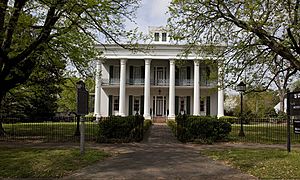
From top, left to right: St. James Hotel and Water Avenue; Edmund Pettus Bridge; National Voting Rights Museum and Institute
|
|||
|
|||
| Nickname(s):
Queen City of the Black Belt, Butterfly Capital of Alabama
|
|||
| Country | United States | ||
| State | Alabama | ||
| County | Dallas | ||
| Founded | 1815 | ||
| Incorporated | 1820 | ||
| Government | |||
| • Type | Mayor–Council | ||
| Area | |||
| • Total | 14.40 sq mi (37.30 km2) | ||
| • Land | 13.81 sq mi (35.77 km2) | ||
| • Water | 0.59 sq mi (1.54 km2) | ||
| Elevation | 135 ft (41 m) | ||
| Population
(2020)
|
|||
| • Total | 17,971 | ||
| • Density | 1,301.40/sq mi (502.46/km2) | ||
| Demonym(s) | Selmarian | ||
| Time zone | UTC−6 (CST) | ||
| • Summer (DST) | UTC−5 (CDT) | ||
| ZIP Codes |
36701-36703
|
||
| Area code | 334 | ||
| FIPS code | 01-69120 | ||
| GNIS ID | 163940 | ||
Selma is a city in and the county seat of Dallas County, in the Black Belt region of south central Alabama and extending to the west. Located on the banks of the Alabama River, the city has a population of 17,971 as of the 2020 census. About 80% of the population is African-American.
Selma was a trading center and market town during the antebellum years of King Cotton in the South. It was also an important armaments-manufacturing and iron shipbuilding center for the Confederacy during the Civil War, surrounded by miles of earthen fortifications. The Confederate forces were defeated during the Battle of Selma, in the final full month of the war.
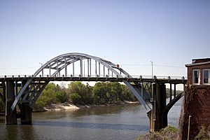
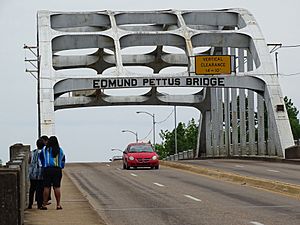
In modern times, the city is best known for the 1960s civil rights movement and the Selma to Montgomery marches, beginning with "Bloody Sunday" in March 1965, when unarmed peaceful protesters were assaulted by County and state highway police.
By the end of March 1965, an estimated 25,000 people entered Montgomery to press for voting rights. This activism generated national attention for social justice. That summer, the Voting Rights Act of 1965 was passed by Congress to authorize federal oversight and enforcement of constitutional rights of all American citizens.
Due to agriculture and industry decline, Selma has lost about a third of its peak population since the 1960s. The city is focusing on heritage tourism, to build on its role as a major influence in civil rights and desegregation.
Selma is one of Alabama's poorest cities, with an average income of $35,500, which is 30% less than the state average. One in every three residents in Selma lives below the state poverty line.
Contents
History
Before settlement by European peoples, the area of present-day Selma had been inhabited for thousands of years by varying cultures of indigenous peoples. The Europeans encountered the historic Native American people known as the Muscogee (also known as the Creek), who had been in the area for hundreds of years.
French explorers and colonists were the first Europeans to explore this area. In 1732, they recorded the site of present-day Selma as Écor Bienville. Later Anglo-Americans called it the Moore's Bluff settlement. Selma was incorporated in 1820. The city was planned and named as Selma by William R. King, a politician and planter from North Carolina who was a future Vice President of the United States. The name, meaning "high seat" or "throne", came from the Ossianic poem The Songs of Selma.
Selma during the Civil War
During the Civil War, Selma was one of the South's main military manufacturing centers, producing tons of supplies and munitions, and building Confederate warships such as the ironclad Tennessee. The Selma iron works and foundry was considered the second-most important source of weaponry for the South, after the Tredegar Iron Works in Richmond, Virginia. This strategic concentration of manufacturing capabilities eventually made Selma a target of Union raids into Alabama late in the Civil War.
Because of its military importance, Selma had been fortified by three miles of earthworks that ran in a semicircle around the city. They were anchored on the north and south by the Alabama River. The works had been built two years earlier, and while neglected for the most part since, were still formidable. They were 8 feet (2.4 m) to 12 feet (3.7 m) high, 15 feet (4.6 m) thick at the base, with a ditch 4 feet (1.2 m) wide and 5 feet (1.5 m) deep along the front. In front of this was a 5 feet (1.5 m) high picket fence of heavy posts planted in the ground and sharpened at the top. At prominent positions, earthen forts were built with artillery in position to cover the ground over which an assault would have to be made.
The North had learned of the importance of Selma to the Confederate military, and Federal military planned to take the city. Gen. William Tecumseh Sherman first made an effort to reach it, but after advancing from the west as far as Meridian, Mississippi, within 107 miles (172 km) of Selma, his forces retreated back to the Mississippi River. Gen. Benjamin Grierson, invading with a cavalry force from Memphis, Tennessee, was intercepted and returned; Gen. Rousseau made a dash in the direction of Selma, but was misled by his guides and struck the railroad forty miles east of Montgomery.
Battle of Selma
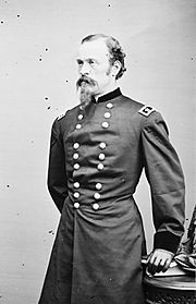
On March 30, 1865, Union General James H. Wilson detached Gen. John T. Croxton's brigade to destroy all Confederate property at Tuscaloosa, Alabama. Wilson's forces captured a Confederate courier, who was found to be carrying dispatches from Confederate General Nathan Bedford Forrest describing his scattered forces. Wilson sent a brigade to destroy the bridge across the Cahaba River at Centreville, which cut off most of Forrest's reinforcements from reaching the area. He began a running fight with Forrest's forces that did not end until after the fall of Selma.
On the afternoon of April 1, after skirmishing all morning, Wilson's advanced guard ran into Forrest's line of battle at Ebenezer Church, where the Randolph Road intersected the main Selma road. Forrest had hoped to bring his entire force to bear on Wilson. Delays caused by flooding, plus earlier contact with the enemy, resulted in Forrest mustering fewer than 2,000 men, many of whom were not war veterans but home militia consisting of old men and young boys.
The outnumbered and outgunned Confederates fought for more than an hour as reinforcements of Union cavalry and artillery were deployed. Forrest was wounded by a saber-wielding Union captain, whom he shot and killed with his revolver. Finally, a Union cavalry charge broke the Confederate militia, causing Forrest to be flanked on his right. He was forced to retreat.
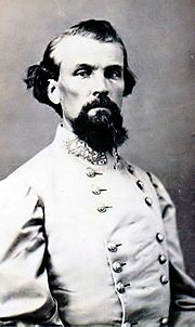
Early the next morning, Forrest reached Selma; he advised Gen. Richard Taylor, departmental commander, to leave the city. Taylor did so after giving Forrest command of the defense. Selma was protected by fortifications that circled much of the city; it was protected on the north and south by the Alabama River. The wall was high and deep, surrounded by a ditch and picket fence. Earthen forts were built to cover the grounds with artillery fire.
Forrest's defenders consisted of his Tennessee escort company, McCullough's Missouri Regiment, Crossland's Kentucky Brigade, Roddey's Alabama Brigade, Frank Armstrong's Mississippi Brigade, General Daniel W. Adams' state reserves, and the citizens of Selma who were "volunteered" to man the works. Altogether this force numbered less than 4,000. As the Selma fortifications were built to be defended by 20,000 men, Forrest's soldiers had to stand 10 to 12 feet (3.7 m) apart to try to cover the works.
Wilson's force arrived in front of the Selma fortifications at 2 p.m. He had placed Gen. Eli Long's Division across the Summerfield Road with the Chicago Board of Trade Battery in support. Gen. Emory Upton's Division was placed across the Range Line Road with Battery I, 4th US Artillery in support. Altogether Wilson had 9,000 troops available for the assault.
The Federal commander's plan was for Upton to send in a 300-man detachment after dark to cross the swamp on the Confederate right; enter the works, and begin a flanking movement toward the center moving along the line of fortifications. A single gun from Upton's artillery would signal the attack to be undertaken by the entire Federal Corps.
At 5 p.m., however, Gen. Eli Long's ammunition train in the rear was attacked by advance elements of Forrest's scattered forces approaching Selma. Both Long and Upton had positioned significant numbers of troops in their rear for just such an event. But, Long decided to begin his assault against the Selma fortifications to neutralize the enemy attack in his rear.
Long's troops attacked in a single rank in three main lines, dismounted and shooting their Spencer's carbines, supported by their own artillery fire. The Confederates replied with heavy small arms and artillery fire. The Southern artillery had only solid shot on hand, while a short distance away was an arsenal which produced tons of canister, a highly effective anti-personnel ammunition.
The Federals suffered many casualties (including General Long) but continued their attack. Once the Union Army reached the works, there was vicious hand-to-hand fighting. Many soldiers were struck down with clubbed muskets, but they kept pouring into the works with their greater numbers. In less than 30 minutes, Long's men had captured the works protecting the Summerfield Road.
Meanwhile, General Upton, observing Long's success, ordered his division forward. They succeeded in overmounting the defenses and soon U.S. flags could be seen waving over the works from Range Line Road to Summerfield Road.
After the outer works fell, General Wilson led the 4th U.S. Cavalry Regiment in a mounted charge down the Range Line Road toward the unfinished inner line of works. The retreating Confederate forces, upon reaching the inner works, united and fired repeatedly together into the charging column. This broke up the charge and sent General Wilson sprawling to the ground when his favorite horse was wounded. He quickly remounted his stricken horse and ordered a dismounted assault by several regiments.
Mixed units of Confederate troops had also occupied the Selma railroad depot and the adjoining banks of the railroad bed to make a stand next to the Plantersville Road (present day Broad Street). The fighting there was heavy, but by 7 p.m. the superior numbers of Union troops had managed to flank the Southern positions. The Confederates abandoned the depot as well as the inner line of works.
In the darkness, the Federals rounded up hundreds of prisoners, but hundreds more escaped down the Burnsville Road, including generals Forrest, Armstrong, and Roddey. To the west, many Confederate soldiers fought the pursuing Union Army all the way down to the eastern side of Valley Creek. They escaped in the darkness by swimming across the Alabama River near the mouth of Valley Creek (where the present day Battle of Selma Reenactment is held.)
The Union troops looted the city that night and burned many businesses and private residences. They spent the next week destroying the arsenal and naval foundry. They left Selma heading to Montgomery. At the war's end, they were en route to Columbus and Macon, Georgia.
Geography
Selma is located at 32°24′26″N 87°1′16″W / 32.40722°N 87.02111°W, west of Montgomery.
According to the U.S. Census Bureau, the city has a total area of 14.4 square miles (37 km2) of which 13.9 square miles (36 km2) is land and 0.6 square miles (1.6 km2) is water.
Demographics
| Historical population | |||
|---|---|---|---|
| Census | Pop. | %± | |
| 1830 | 401 | — | |
| 1840 | 1,199 | 199.0% | |
| 1850 | 3,073 | 156.3% | |
| 1860 | 3,177 | 3.4% | |
| 1870 | 6,484 | 104.1% | |
| 1880 | 7,529 | 16.1% | |
| 1890 | 7,622 | 1.2% | |
| 1900 | 8,713 | 14.3% | |
| 1910 | 13,649 | 56.7% | |
| 1920 | 15,589 | 14.2% | |
| 1930 | 18,012 | 15.5% | |
| 1940 | 19,834 | 10.1% | |
| 1950 | 22,840 | 15.2% | |
| 1960 | 28,385 | 24.3% | |
| 1970 | 27,379 | −3.5% | |
| 1980 | 26,684 | −2.5% | |
| 1990 | 23,755 | −11.0% | |
| 2000 | 20,512 | −13.7% | |
| 2010 | 20,872 | 1.8% | |
| 2020 | 17,971 | −13.9% | |
| U.S. Decennial Census 2018 Estimate |
|||
2020 census
| Race | Num. | Perc. |
|---|---|---|
| White | 2,573 | 14.32% |
| Black or African American | 14,757 | 82.12% |
| Native American | 26 | 0.14% |
| Asian | 107 | 0.6% |
| Pacific Islander | 6 | 0.03% |
| Other/Mixed | 368 | 2.05% |
| Hispanic or Latino | 134 | 0.75% |
As of the 2020 United States Census, there were 17,971 people, 7,612 households, and 4,517 families residing in the city.
2010 census
As of the 2010 census, there were 20,756 people living in the city. The racial makeup of the city was 80.3% Black or African American, 18.0% White, 0.20% Native American, 0.60% Asian, 0.1% other races, 0.80% from two or more races and Hispanics or Latinos, of any race, comprised 0.60% of the population.
Economy
Industries in Selma include International Paper, Bush Hog (agricultural equipment), Plantation Patterns, American Apparel, and Peerless Pump Company (LaBour), Renasol, and Hyundai.
The city and rural region have struggled economically, as agriculture does not provide enough jobs. There was a downturn after restructuring in industry that had done well into the 1960s.
Civil rights tourism has become a new source of business.
Arts and culture
Arts
Cultural events are held at the Performing Arts Center, and the Selma Art Guild Gallery.
Museums and points of interest
Museums in the city include Sturdivant Hall, the National Voting Rights Museum, Historic Water Avenue, Martin Luther King, Jr. Street Historic Walking Tour, Old Depot Museum, Joe Calton Bates Children Education and History Museum, Vaughan-Smitherman Museum and Heritage Village.
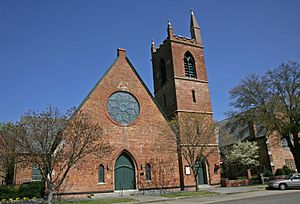
Selma boasts the state's largest contiguous historic district, with more than 1,250 structures identified as contributing. Area attractions include the Old Town Historic District, Old Live Oak Cemetery, Paul M. Grist State Park, and Old Cahawba Archaeological Park.
The complex history is reflected in naming and monuments as well. Highway 80, which runs east and west through Selma and the state has reflected this in naming patterns. In 1920 the east-west Highway 80 was designated as part of the Jefferson Davis Memorial Highway. In 1977 US 80 was named Givhan Parkway in honor of the long-serving state senator Walter C. Givhan, a segregationist to the end. In 1996 it was designated as part of the 'National Civil Rights Trail' by President Bill Clinton and is administered by the National Park Service. In 2000 sections of Highway 80 leading into Selma were renamed in honor of leaders in the Selma Voting Rights Movement: F.D. Reese, Marie Foster, and Amelia Boynton.
As part of its Civil War history, a monument to native Nathan Bedford Forrest, a Confederate General, was installed in Old Live Oak Cemetery. It was torn down in 2012, reflecting the continuing controversy about him. In August 2012, plans were announced to build a larger monument, more resistant to vandalism, but many African Americans object to it because of his established history as a postwar leader with the KKK and his earlier involvement in the massacre of black Union troops at Fort Pillow.
Library
The Selma-Dallas County Public Library serves the city and the region with a collection of 76,751 volumes. It was established as a Carnegie library in 1904, receiving matching funds for construction. The 25,000 square feet (2,300 m2) library is in downtown Selma.
Transportation
Airports
- Craig Field (SEM), located four nautical miles (4.6 mi; 7.4 km) southeast of the central business district of Selma.
Education
Colleges and universities
Colleges in Selma include Selma University and Wallace Community College Selma, which is located at the edge of the city limits near Valley Grande, Alabama. Concordia College Alabama, a private Lutheran university, operated in Selma from 1922 to 2018. Daniel Payne College, an institution of the African Methodist Episcopal Church, operated in Selma from 1889 to 1922.
Public
Selma City Schools operates the city's public schools. The public high school is Selma High School. Middle schools include R.B. Hudson Middle School and the School of Discovery. The city has eight elementary schools.
Private
Selma has four private K–12 schools: John T. Morgan Academy, founded in 1965, Meadowview Christian School, Ellwood Christian Academy, and Cathedral Christian Academy.
Media
Selma is served by the Montgomery-Selma television Designated Market Area (DMA). Charter Communications provides cable television service. DirecTV and Dish Network provide direct broadcast satellite television including both local and national channels to area residents.
Radio stations
- WALX 100.9 FM (Classic Hits)
- WAPR 88.3 FM (Educational)
- WAQU 91.1 FM (Christian)
- WDXX 100.1 FM (country)
- WHBB 1490 AM (news/Talk/Gospel)
- WJAM 1340 AM/96.3 FM (Urban adult contemporary)
- WRNF 89.5 FM (Religious)
- WBFZ 105.3 FM ([Gospel Blues R&B Talk])
Television stations
- WAKA (Channel 8) CBS
- WBIH (Channel 29) Independent
Newspaper
- Selma Times-Journal (daily)
- Selma Sun (weekly)
Notable people
- Zinn Beck – Major League Baseball player; managed the first Selma Cloverleafs from 1928 to 1930, winning the Southeastern League pennant in 1930
- Ann Bedsole – Alabama State Representative (1979), first female member of the Alabama Senate (1983)
- Patricia Swift Blalock – librarian and civil rights movement activist
- Jo Bonner – U.S. Representative for Alabama (2003)
- Frances Hawks Cameron Burnett – diplomat's wife, poet
- Edgar Cayce – psychic who worked and lived in Selma
- J.L. Chestnut – author, attorney, and civil rights movement activist
- Jim Clark – Dallas County Sheriff leading the attacks on citizens during the 1964–1965 voter registration campaign in Selma
- Mattie Moss Clark – Gospel music artist & choir director, mother/founder of The Clark Sisters
- Annie Lee Cooper – civil rights movement activist
- Charles Davis – member of the Azerbaijan national basketball team
- Howard W. Gilmore – World War II submarine commander who posthumously received the Medal of Honor
- Jimmy Gresham – soul musician
- Gunnar Henderson- MLB Player for the Baltimore Orioles
- Mia Hamm – Women's United Soccer Association player, Olympic gold medallist
- Jeremiah Haralson – slave, farmer and politician who lived here from 1859; he was the first African American from the state to be elected an Alabama State Representative (1870), Alabama State Senator (1872), and U.S. Representative (1875)
- Candy Harris – Major League Baseball player
- Hunter Haynes, inventor and early black filmmaker
- Sam Hobbs – U.S. Representative (1935)
- Katharine Hopkins Chapman (1870/72/73-1930) - author and historian
- Eunice W. Johnson – founder and director of the EbonyFashion Fair
- Michael Johnson – National Football League player
- James Ralph "Shug" Jordan – head football coach of Auburn University
- William Rufus King – Vice President of the United States (1853), U.S. Senator (1844), U.S. Minister to France (1848)
- Terry Leach – Major League Baseball player, namesake of Leach Field at Bloch Park
- Bogart Leashore – social worker, sociologist, dean of Hunter College school of social work (1991–2003)
- Larry Marks – professional boxer
- William Clarence Matthews – baseball player, first head football coach for Tuskegee University, lawyer, and civil rights movement activist
- Pat McHugh – National Football League player
- Darrio Melton – Alabama State Representative (2010), Mayor of Selma (2016)
- John Melvin – first American naval officer to die in World War I
- Olan Mills Sr. – photographer and founder of Olan Mills
- Johnny Moore – lead singer for The Drifters
- Ben Obomanu – National Football League player
- Shwetak Patel – computer scientist and entrepreneur
- James Perkins, Jr. – first African American mayor of Selma (2000)
- Edmund Pettus – U.S. Senator, Brigadier General in Confederate States Army
- Minnie Bruce Pratt – educator, activist, and essayist
- Cal Ramsey – National Basketball Association player
- Frederick D. Reese – civil rights movement leader
- Amelia Boynton Robinson – civil rights movement leader
- Richard Scrushy – founder of HealthSouth
- Jeff Sessions – United States Attorney General, U.S. Senator for Alabama
- Terri Sewell – U.S. Representative for Alabama
- Lachavious Simmons – National Football League player
- Benjamin S. Turner – first African American U.S. Representative from Alabama (1871)
- Hattie Hooker Wilkins – first woman elected to the Alabama Legislature (in its Alabama House of Representatives, 1923)
- Kathryn Tucker Windham – storyteller, author, photographer, and journalist
- Asher HaVon - singer, winner of NBC's The Voice
Sports
Selma's Bloch Park was home to Southeastern League of Professional Baseball club the Selma Cloverleafs.
See also
 In Spanish: Selma (Alabama) para niños


