Cassville, Missouri facts for kids
Quick facts for kids
Cassville, Missouri
|
|
|---|---|

Location of Cassville, Missouri
|
|
| Country | United States |
| State | Missouri |
| County | Barry |
| Township | Flat Creek |
| Area | |
| • Total | 3.42 sq mi (8.87 km2) |
| • Land | 3.42 sq mi (8.86 km2) |
| • Water | 0.00 sq mi (0.00 km2) |
| Elevation | 1,319 ft (402 m) |
| Population
(2020)
|
|
| • Total | 3,190 |
| • Density | 931.93/sq mi (359.86/km2) |
| Time zone | UTC-6 (Central (CST)) |
| • Summer (DST) | UTC-5 (CDT) |
| ZIP codes |
65623, 65625
|
| Area code(s) | 417 |
| FIPS code | 29-11890 |
| GNIS feature ID | 2393769 |
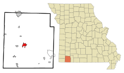
Cassville is a city in Flat Creek Township, Barry County, Missouri, United States. According to the 2020 census, the population of Cassville was 3,190. Cassville is one of the primary markets and job centers for an estimated 14,000 people living in the surrounding area. It is the county seat of Barry County.
Contents
History
The land which would be called Cassville was platted in 1845. A post office was set up the same year. The community was named after Lewis Cass, a former United States Senator and Secretary of War. The town was laid out along the Old Wire Road that ran from Jefferson Barracks Saint Louis, Missouri to Fort Smith, Arkansas. It was a Flag Stop on the Butterfield Overland Mail Route. Cassville was incorporated on March 3, 1847.
Cassville served as the Confederate capital of Missouri for one week from October 29 to November 7, 1861. This ended abruptly when the Confederate government was pushed further south into Arkansas by the invading Union army. The Battle of Pea Ridge later secured Missouri for the Union.
The city was connected by rail via the Cassville & Exeter Railroad from July 4, 1896, to September 11, 1956.
The Cassville Ranger Station Historic District, Natural Bridge Archaeological Site, and six sites in Roaring River State Park are listed on the National Register of Historic Places.
Demographics
| Historical population | |||
|---|---|---|---|
| Census | Pop. | %± | |
| 1870 | 287 | — | |
| 1890 | 626 | — | |
| 1900 | 702 | 12.1% | |
| 1910 | 781 | 11.3% | |
| 1920 | 1,002 | 28.3% | |
| 1930 | 1,016 | 1.4% | |
| 1940 | 1,214 | 19.5% | |
| 1950 | 1,441 | 18.7% | |
| 1960 | 1,451 | 0.7% | |
| 1970 | 1,910 | 31.6% | |
| 1980 | 2,091 | 9.5% | |
| 1990 | 2,371 | 13.4% | |
| 2000 | 2,890 | 21.9% | |
| 2010 | 3,266 | 13.0% | |
| 2020 | 3,190 | −2.3% | |
| U.S. Decennial Census | |||
2010 census
As of the census of 2010, there were 3,266 people, 1,275 households, and 848 families living in the city. The population density was 1,014.3 inhabitants per square mile (391.6/km2). There were 1,402 housing units at an average density of 435.4 per square mile (168.1/km2). The racial makeup of the city was 93.8% European American, 0.4% African American, 1.7% Native American, 0.3% Asian, 2.1% from other races, and 1.8% from two or more races. Hispanic or Latino of any race were 4.6% of the population.
There were 1,275 households, of which 34.2% had children under the age of 18 living with them, 48.9% were married couples living together, 13.1% had a female householder with no husband present, 4.5% had a male householder with no wife present, and 33.5% were non-families. 30.0% of all households were made up of individuals, and 16% had someone living alone who was 65 years of age or older. The average household size was 2.43 and the average family size was 2.99.
The median age in the city was 40.5 years. 23.8% of residents were under the age of 18; 8.4% were between the ages of 18 and 24; 23% were from 25 to 44; 25.3% were from 45 to 64; and 19.3% were 65 years of age or older. The gender makeup of the city was 46.8% male and 53.2% female.
Education
Cassville R-IV School District operates one elementary school, one middle school, one intermediate school, and Cassville High School.
Cassville has a public library, a branch of the Barry-Lawrence Regional Library.
Crowder College offers two-year degree programs in Cassville.
In August 2022 the district reintroduced corporal punishment after a gap of about 20 years. Administrators say it would be the last resort if other means of discipline do not work. This is an opt-in only option for parents, so anyone who disagrees with corporal punishment, simply do not by not opt in.
Transportation
The city owns a small general aviation airport two miles northwest of Cassville, named the Cassville Municipal Airport.
Notable people
- Clete Boyer - Major League Baseball player born in Cassville
- Mary Easley - Oklahoma Senator (2004-2010), Oklahoma Representative (1997-2004), teacher
- Curtis F. Marbut - Director of the Soil Survey Division of the U.S. Department of Agriculture
- Scott Fitzpatrick - Missouri State Auditor, former Missouri State Treasurer, and former Missouri State representative.
Geography
According to the United States Census Bureau, the city has a total area of 3.22 square miles (8.34 km2), all land. Located in the Ozarks, Cassville and its surrounding area have a densely forested hilly terrain. The city, itself, sits on Flat Creek. Located south of Cassville, Roaring River State Park is a popular recreation spot for hiking, fishing, and camping.
Climate
Climate in this area is characterized by relatively high temperatures and evenly distributed precipitation throughout the year. The Köppen Climate Classification subtype for this climate is "Cfa" (Humid Subtropical Climate).
| Climate data for Cassville, Missouri (1991–2020 normals, extremes 1911–present) | |||||||||||||
|---|---|---|---|---|---|---|---|---|---|---|---|---|---|
| Month | Jan | Feb | Mar | Apr | May | Jun | Jul | Aug | Sep | Oct | Nov | Dec | Year |
| Record high °F (°C) | 77 (25) |
86 (30) |
86 (30) |
92 (33) |
92 (33) |
101 (38) |
106 (41) |
108 (42) |
102 (39) |
96 (36) |
85 (29) |
78 (26) |
108 (42) |
| Mean daily maximum °F (°C) | 43.6 (6.4) |
48.9 (9.4) |
58.0 (14.4) |
67.3 (19.6) |
74.6 (23.7) |
82.7 (28.2) |
87.0 (30.6) |
86.8 (30.4) |
79.6 (26.4) |
69.6 (20.9) |
57.2 (14.0) |
46.9 (8.3) |
66.9 (19.4) |
| Daily mean °F (°C) | 33.4 (0.8) |
37.6 (3.1) |
46.5 (8.1) |
55.4 (13.0) |
64.2 (17.9) |
72.4 (22.4) |
76.6 (24.8) |
75.7 (24.3) |
67.8 (19.9) |
57.7 (14.3) |
46.1 (7.8) |
36.7 (2.6) |
55.8 (13.2) |
| Mean daily minimum °F (°C) | 23.2 (−4.9) |
26.3 (−3.2) |
35.0 (1.7) |
43.5 (6.4) |
53.8 (12.1) |
62.1 (16.7) |
66.2 (19.0) |
64.6 (18.1) |
56.0 (13.3) |
45.8 (7.7) |
35.0 (1.7) |
26.5 (−3.1) |
44.8 (7.1) |
| Record low °F (°C) | −19 (−28) |
−24 (−31) |
−2 (−19) |
17 (−8) |
26 (−3) |
36 (2) |
41 (5) |
39 (4) |
29 (−2) |
15 (−9) |
2 (−17) |
−15 (−26) |
−24 (−31) |
| Average precipitation inches (mm) | 2.50 (64) |
2.32 (59) |
3.88 (99) |
5.00 (127) |
6.18 (157) |
4.77 (121) |
4.20 (107) |
3.27 (83) |
4.56 (116) |
3.77 (96) |
3.87 (98) |
3.09 (78) |
47.41 (1,204) |
| Source: NOAA | |||||||||||||
See also
 In Spanish: Cassville (Misuri) para niños


