Barry County, Missouri facts for kids
Quick facts for kids
Barry County
|
|
|---|---|

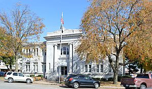
The Barry County Courthouse in Cassville
|
|

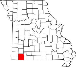
Location within the U.S. state of Missouri
|
|
 Missouri's location within the U.S. |
|
| Country | |
| State | |
| Founded | January 5, 1835 |
| Named for | William Taylor Barry |
| Seat | Cassville |
| Largest city | Monett |
| Area | |
| • Total | 791 sq mi (2,050 km2) |
| • Land | 778 sq mi (2,020 km2) |
| • Water | 13 sq mi (30 km2) 1.6% |
| Population
(2020)
|
|
| • Total | 34,534 |
| • Density | 43.659/sq mi (16.857/km2) |
| Time zone | UTC−6 (Central) |
| • Summer (DST) | UTC−5 (CDT) |
| Congressional district | 7th |
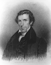
Barry County is a county located in the southwest portion of the U.S. state of Missouri. As of the 2020 Census, the population was 34,534. Its county seat is Cassville. The county was organized in 1835 and named after William Taylor Barry, a U.S. Postmaster General from Kentucky. The town of Barry, also named after the postmaster-general, was located just north of Kansas City, not in Barry County.
Contents
Geography
According to the U.S. Census Bureau, the county has a total area of 791 square miles (2,050 km2), of which 778 square miles (2,020 km2) is land and 13 square miles (34 km2) (1.6%) is water. Roaring River State Park is located in the southern part of the county, amid the Mark Twain National Forest.
Adjacent counties
- Lawrence County (north)
- Stone County (east)
- Carroll County, Arkansas (southeast)
- Benton County, Arkansas (south)
- McDonald County (southwest)
- Newton County (northwest)
Major highways
National protected area
- Mark Twain National Forest (part)
Demographics
| Historical population | |||
|---|---|---|---|
| Census | Pop. | %± | |
| 1840 | 4,745 | — | |
| 1850 | 3,467 | −26.9% | |
| 1860 | 7,995 | 130.6% | |
| 1870 | 10,373 | 29.7% | |
| 1880 | 14,405 | 38.9% | |
| 1890 | 22,943 | 59.3% | |
| 1900 | 25,532 | 11.3% | |
| 1910 | 23,869 | −6.5% | |
| 1920 | 23,473 | −1.7% | |
| 1930 | 22,803 | −2.9% | |
| 1940 | 23,546 | 3.3% | |
| 1950 | 21,755 | −7.6% | |
| 1960 | 18,921 | −13.0% | |
| 1970 | 19,597 | 3.6% | |
| 1980 | 24,408 | 24.5% | |
| 1990 | 27,547 | 12.9% | |
| 2000 | 34,010 | 23.5% | |
| 2010 | 35,597 | 4.7% | |
| 2020 | 34,534 | −3.0% | |
| U.S. Decennial Census 1790–1960 1900–1990 1990–2000 2010–2015 |
|||
As of the census of 2000, there were 34,010 people, 13,398 households, and 9,579 families residing in the county. The population density was 44 people per square mile (17 people/km2). There were 15,964 housing units at an average density of 20 units per square mile (7.7/km2). The racial makeup of the county was 94.09% White, 0.11% Black or African American, 0.86% Native American, 0.27% Asian, 0.03% Pacific Islander, 3.25% from other races, and 1.38% from two or more races. Approximately 5.04% of the population were Hispanic or Latino of any race. 26.5% were of American, 15.5% German, 11.7% English and 10.4% Irish ancestry.
There were 13,398 households, out of which 31.20% had children under the age of 18 living with them, 59.30% were married couples living together, 8.40% had a female householder with no husband present, and 28.50% were non-families. 24.70% of all households were made up of individuals, and 11.60% had someone living alone who was 65 years of age or older. The average household size was 2.51 and the average family size was 2.98.
In the county, the population was spread out, with 26.10% under the age of 18, 7.80% from 18 to 24, 26.10% from 25 to 44, 23.90% from 45 to 64, and 16.10% who were 65 years of age or older. The median age was 38 years. For every 100 females there were 98.30 males. For every 100 females age 18 and over, there were 95.60 males.
The median income for a household in the county was $28,906, and the median income for a family was $34,043. Males had a median income of $25,381 versus $18,631 for females. The per capita income for the county was $14,980. About 11.80% of families and 16.60% of the population were below the poverty line, including 23.50% of those under age 18 and 11.90% of those age 65 or over.
Religion
According to the Association of Religion Data Archives County Membership Report (2010), Barry County is regarded as being a part of the Bible Belt, with evangelical Protestantism being the most predominant religion. The most predominant denominations among residents in Barry County who adhere to a religion are Southern Baptists (50.27%), Roman Catholics (19.26%), and United Methodists (4.67%).
2020 Census
| Race | Num. | Perc. |
|---|---|---|
| White (NH) | 28,058 | 81.3% |
| Black or African American (NH) | 102 | 0.3% |
| Native American (NH) | 316 | 1% |
| Asian (NH) | 808 | 2.34% |
| Pacific Islander (NH) | 70 | 0.2% |
| Other/Mixed (NH) | 1,847 | 5.4% |
| Hispanic or Latino | 3,333 | 9.7% |
Education
Public schools
- Cassville R-IV School District – Cassville
- Eunice Thomas Elementary School (PK-02)
- Cassville Intermediate School (03-05)
- Cassville Middle School (06-08)
- Cassville High School (09-12)
- Exeter R-VI School District – Exeter
- Exeter Elementary School (K-08)
- Exeter High School (09-12)
- Monett R-I School District – Monett
- Monett Elementary School (PK-02)
- Central Park Elementary School (03-04)
- Monett Intermediate School (05-06)
- Monett Middle School (07-08)
- Monett High School (09-12)
- Purdy R-II School District Purdy
- Purdy Elementary School (K-04)
- Purdy Middle School (05-08)
- Purdy High School (09-12)
- Shell Knob School District No. 78 – Shell Knob
- Shell Knob Elementary School (K-08)
- Southwest R-V School District Washburn
- Southwest Elementary School (PK-04)
- Southwest Middle School (05-08)
- Southwest High School (09-12)
- Wheaton R-III School District – Wheaton
- Wheaton Elementary School (PK-06)
- Wheaton High School (07-12)
Private schools
- St. Lawrence Catholic School – Monett (K-06) – Roman Catholic
Public libraries
- Barry-Lawrence Regional Library
Communities
Cities
Villages
Census-designated places
- Eagle Rock
- Golden
- Shell Knob (partly in Stone County)
Other unincorporated communities
Townships
Barry County is divided into 25 townships:
- Ash
- Butterfield
- Capps Creek
- Corsicana
- Crane Creek
- Exeter
- Flat Creek
- Jenkins
- Kings Prairie
- Liberty
- McDonald
- McDowell
- Mineral
- Monett
- Mountain
- Ozark
- Pioneer
- Pleasant Ridge
- Purdy
- Roaring River
- Shell Knob
- Sugar Creek
- Washburn
- Wheaton
- White River
Notable people
- Clete Boyer – Major League Baseball player
- Scott Fitzpatrick – Missouri State Treasurer (2019–present)
- Don Johnson – Actor
- Curtis F. Marbut – Director of the Soil Survey Division of the U.S. Department of Agriculture (1913–1935)
See also
 In Spanish: Condado de Barry (Misuri) para niños


