Cape May Point, New Jersey facts for kids
Quick facts for kids
Cape May Point, New Jersey
|
||
|---|---|---|
|
Borough
|
||
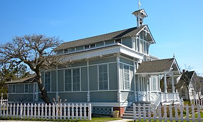
Saint Peter's-By-The-Sea Episcopal Church
|
||
|
||

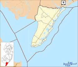
Location of Cape May Point in Cape May County highlighted in red (left). Inset map: Location of Cape May County in New Jersey highlighted in orange (right).
|
||

Census Bureau map of Cape May Point, New Jersey
|
||
| Country | ||
| State | ||
| County | ||
| Incorporated | April 19, 1878 | |
| Named for | Cape May / Cornelius Jacobsen May | |
| Government | ||
| • Type | Walsh Act | |
| • Body | Board of Commissioners | |
| Area | ||
| • Total | 0.31 sq mi (0.81 km2) | |
| • Land | 0.29 sq mi (0.76 km2) | |
| • Water | 0.02 sq mi (0.05 km2) 5.81% | |
| Area rank | 553rd of 565 in state 16th of 16 in county |
|
| Elevation | 7 ft (2 m) | |
| Population
(2020)
|
||
| • Total | 305 | |
| • Estimate
(2023)
|
299 | |
| • Rank | 560th of 565 in state 16th of 16 in county |
|
| • Density | 1,034.0/sq mi (399.2/km2) | |
| • Density rank | 380th of 565 in state 7th of 16 in county |
|
| Time zone | UTC−05:00 (Eastern (EST)) | |
| • Summer (DST) | UTC−04:00 (Eastern (EDT)) | |
| ZIP Code |
08212
|
|
| Area code(s) | 609 exchanges: 884, 898 | |
| FIPS code | 3400910330 | |
| GNIS feature ID | 0885179 | |
Cape May Point is a borough located at the tip of the Cape May Peninsula in Cape May County, in the U.S. state of New Jersey. The borough, and all of Cape May County, is part of the Ocean City metropolitan statistical area, and is part of the Philadelphia-Wilmington-Camden, PA-NJ-DE-MD combined statistical area, also known as the Delaware Valley or Philadelphia metropolitan area. As of the 2020 United States census, the borough's population was 305, an increase of 14 (+4.8%) from the 2010 census count of 291, which in turn reflected an increase of 50 (+20.7%) from the 241 counted in the 2000 census. The summer population can reach 4,500.
The Cape May Light is located in Lower Township, but is also a point of identity for Cape May Point as it uses the lighthouse as a logo for municipal-owned vehicles. Mayors of the two municipalities previously had a conflict over in which municipality it was located.
Cape May Point is a dry town, one of three municipalities in Cape May County where the sale of alcohol is prohibited by law. Cape May Point, Ocean City and Wildwood Crest are Cape May County's only remaining dry municipalities.
Contents
History
Cape May Point was called Stites Beach until 1876 when the name was changed to Seagrove. It was incorporated as a borough by an act of the New Jersey Legislature on April 19, 1878, from portions of Lower Township, based on the results of a referendum held three days earlier. It was reincorporated on August 19, 1891 and returned to Lower Township on April 8, 1896. Cape May Point re-emerged as an independent municipality on April 6, 1908, based on the results of a referendum held on April 21, 1908. The borough's name derives from Cape May, which was named for 1620 Dutch captain named Cornelius Jacobsen May who explored and charted the area between 1611–1614, and established a claim for the province of New Netherland.
The remains of SS Atlantus World War I-era concrete ship are located of the coast of Cape May Point, next to Sunset Beach.
Geography
According to the United States Census Bureau, the borough had a total area of 0.31 square miles (0.81 km2), including 0.30 square miles (0.76 km2) of land and 0.02 square miles (0.05 km2) of water (5.81%).
Cape May Point borders Lower Township, the Atlantic Ocean and Delaware Bay.
Cityscape
In 2004, the borough had about 600 houses. Circa 2004 prices of housing increased, and in 2004 a four bedroom house typically had a price of $1 million.
In 2021 the median price of a house is $1,090,000, which was the highest of any municipality on Cape Island. Most houses are on 50 by 100 feet (15 by 30 m) lots and are below 2,100 square feet (200 m2) in area due to the borough's zoning regulations. Julie Lasky of The New York Times wrote that "the houses appear relatively modest", and that the borough "lacks the fanciful architecture of Cape May".
In 2004 the only two businesses in Cape May Point were the Cape May Bird Observatory bird shop and the Cape May Point General Store.
Demographics
| Historical population | |||
|---|---|---|---|
| Census | Pop. | %± | |
| 1880 | 198 | — | |
| 1890 | 167 | −15.7% | |
| 1900 | 153 | −8.4% | |
| 1910 | 162 | 5.9% | |
| 1920 | 121 | −25.3% | |
| 1930 | 104 | −14.0% | |
| 1940 | 126 | 21.2% | |
| 1950 | 198 | 57.1% | |
| 1960 | 263 | 32.8% | |
| 1970 | 204 | −22.4% | |
| 1980 | 255 | 25.0% | |
| 1990 | 248 | −2.7% | |
| 2000 | 241 | −2.8% | |
| 2010 | 291 | 20.7% | |
| 2020 | 305 | 4.8% | |
| 2023 (est.) | 299 | 2.7% | |
| Population sources:1880–2000 1880–1920 1880–1890 1890-1910 1910–1930 1940–2000 2010> 2020 |
|||
2010 census
The 2010 United States census counted 291 people, 164 households, and 100 families in the borough. The population density was 984.5 per square mile (380.1/km2). There were 619 housing units at an average density of 2,094.2 per square mile (808.6/km2). The racial makeup was 94.50% (275) White, 2.75% (8) Black or African American, 0.00% (0) Native American, 0.34% (1) Asian, 0.00% (0) Pacific Islander, 0.34% (1) from other races, and 2.06% (6) from two or more races. Hispanic or Latino of any race were 0.34% (1) of the population.
Of the 164 households, 4.3% had children under the age of 18; 55.5% were married couples living together; 3.7% had a female householder with no husband present and 39.0% were non-families. Of all households, 34.1% were made up of individuals and 20.7% had someone living alone who was 65 years of age or older. The average household size was 1.77 and the average family size was 2.17.
4.1% of the population were under the age of 18, 1.7% from 18 to 24, 3.8% from 25 to 44, 34.7% from 45 to 64, and 55.7% who were 65 years of age or older. The median age was 66.4 years. For every 100 females, the population had 84.2 males. For every 100 females ages 18 and older there were 83.6 males.
The Census Bureau's 2006–2010 American Community Survey showed that (in 2010 inflation-adjusted dollars) median household income was $51,250 (with a margin of error of +/− $36,659) and the median family income was $71,875 (+/− $10,854). Males had a median income of $108,125 (+/− $225,840) versus $ (+/− $) for females. The per capita income for the borough was $37,269 (+/− $13,473). About 8.7% of families and 9.4% of the population were below the poverty line, including none of those under age 18 and 12.7% of those age 65 or over.
Education
Cape May Point School District is a non-operating school district, with all students sent to schools outside of the district. It opened a two story grade 1–8 school in the 1870. It began sending students to Lower Township School District in 1931 and closed the former school, which is now a house. Cape May Point under Frank Rutherford, the mayor, chose not to join the Lower Cape May Regional School District when it was formed. The borough never joined a regional school system. Therefore, in 2004, it had among the lowest property tax rates in New Jersey.
For pre-kindergarten through sixth grade, public school students attend Cape May City Elementary School in Cape May City, as part of a sending/receiving relationship with the Cape May City School District. Most students in the Cape May elementary district come from the United States Coast Guard Training Center Cape May. As of the 2021–22 school year, the district, comprised of one school, had an enrollment of 169 students and 22.6 classroom teachers (on an FTE basis), for a student–teacher ratio of 7.5:1. Starting in 2010, discussions were under way regarding a possible consolidation of the districts of Cape May City, Cape May Point and the West Cape May School District.
For seventh through twelfth grades, public school students attend the schools of the Lower Cape May Regional School District as part of a sending/receiving relationship; the district also serves students from the constituent communities of Cape May City, Lower Township and West Cape May. Schools in the district (with 2022–23 enrollment data from the National Center for Education Statistics) are Richard M. Teitelman Middle School with 433 students in grades 7-8 and Lower Cape May Regional High School (LCMRHS) with 757 students in grades 9-12.
Students are also eligible to attend Cape May County Technical High School in Cape May Court House, which serves students from the entire county in its comprehensive and vocational programs, which are offered without charge to students who are county residents. Special needs students may be referred to Cape May County Special Services School District in the Cape May Court House area.
Transportation
As of May 2010[update], the borough had a total of 7.39 miles (11.89 km) of roadways, of which 5.52 miles (8.88 km) were maintained by the municipality and 1.87 miles (3.01 km) by Cape May County.
No Interstate, U.S., state or major county highways serve Cape May Point. The most significant roads in the borough are minor county routes, such as County Route 629.
Climate
According to the Köppen climate classification system, Cape May Point has a humid subtropical climate (Cfa) with hot, moderately humid summers, cool winters and year-around precipitation. Cfa climates are characterized by all months having an average mean temperature above 32.0 °F (0.0 °C), at least four months with an average mean temperature at or above 50.0 °F (10.0 °C), at least one month with an average mean temperature at or above 71.6 °F (22.0 °C) and no significant precipitation difference between seasons. During the summer months in Cape May Point, a cooling afternoon sea breeze is present on most days, but episodes of extreme heat and humidity can occur with heat index values at or above 95.0 °F (35.0 °C). During the winter months, episodes of extreme cold and wind can occur with wind chill values below 0.0 °F (−17.8 °C). The plant hardiness zone at Cape May Point Beach is 7b with an average annual extreme minimum air temperature of 8.1 °F (−13.3 °C). The average seasonal (November–April) snowfall total is around 12 inches (30 cm), and the average snowiest month is February which corresponds with the annual peak in nor'easter activity.
| Climate data for Cape May Point Beach, NJ (1981–2010 Averages) | |||||||||||||
|---|---|---|---|---|---|---|---|---|---|---|---|---|---|
| Month | Jan | Feb | Mar | Apr | May | Jun | Jul | Aug | Sep | Oct | Nov | Dec | Year |
| Mean daily maximum °F (°C) | 41.9 (5.5) |
43.7 (6.5) |
50.4 (10.2) |
59.4 (15.2) |
68.6 (20.3) |
77.7 (25.4) |
82.0 (27.8) |
81.1 (27.3) |
75.8 (24.3) |
66.1 (18.9) |
56.3 (13.5) |
46.7 (8.2) |
62.6 (17.0) |
| Daily mean °F (°C) | 35.3 (1.8) |
37.0 (2.8) |
43.3 (6.3) |
52.3 (11.3) |
61.4 (16.3) |
70.8 (21.6) |
75.6 (24.2) |
74.9 (23.8) |
69.5 (20.8) |
59.1 (15.1) |
49.7 (9.8) |
40.2 (4.6) |
55.8 (13.2) |
| Mean daily minimum °F (°C) | 28.6 (−1.9) |
30.2 (−1.0) |
36.3 (2.4) |
45.3 (7.4) |
54.2 (12.3) |
63.8 (17.7) |
69.1 (20.6) |
68.6 (20.3) |
63.1 (17.3) |
52.2 (11.2) |
43.0 (6.1) |
33.8 (1.0) |
49.1 (9.5) |
| Average precipitation inches (mm) | 3.36 (85) |
2.80 (71) |
4.16 (106) |
3.64 (92) |
3.63 (92) |
3.19 (81) |
3.79 (96) |
4.07 (103) |
3.24 (82) |
3.62 (92) |
3.23 (82) |
3.61 (92) |
42.34 (1,075) |
| Average relative humidity (%) | 68.9 | 67.7 | 66.0 | 64.5 | 68.9 | 73.0 | 72.9 | 75.4 | 72.1 | 71.0 | 69.7 | 69.4 | 70.0 |
| Average dew point °F (°C) | 26.1 (−3.3) |
27.3 (−2.6) |
32.7 (0.4) |
40.7 (4.8) |
51.1 (10.6) |
61.7 (16.5) |
66.3 (19.1) |
66.6 (19.2) |
60.1 (15.6) |
49.7 (9.8) |
40.2 (4.6) |
31.0 (−0.6) |
46.2 (7.9) |
| Source: PRISM | |||||||||||||
| Climate data for North Cape May, NJ Ocean Water Temperature (2 N Cape May Point) | |||||||||||||
|---|---|---|---|---|---|---|---|---|---|---|---|---|---|
| Month | Jan | Feb | Mar | Apr | May | Jun | Jul | Aug | Sep | Oct | Nov | Dec | Year |
| Daily mean °F (°C) | 37 (3) |
37 (3) |
42 (6) |
50 (10) |
59 (15) |
68 (20) |
73 (23) |
74 (23) |
72 (22) |
61 (16) |
52 (11) |
42 (6) |
56 (13) |
| Source: NOAA | |||||||||||||
Ecology
According to the A. W. Kuchler U.S. potential natural vegetation types, Cape May Point would have a dominant vegetation type of Northern Cordgrass (73) with a dominant vegetation form of Coastal Prairie (20).
Places of interest
The Sisters of St. Joseph maintained the Queen of the Sea facility, a convent called the Saint Joseph House, and a retreat facility called Saint Mary by-the-Sea. Bill Barlow of the Press of Atlantic City wrote that it is "A beloved local landmark". Its facilities are not connected with the Roman Catholic Diocese of Camden.
Saint Mary opened as the Shoreham Hotel in 1889. After the business failed, it became a nursing home for African Americans in 1898, known as Home for Aged and Infirm Colored People. It later closed, and the sisters spent $9,000 to buy the property in 1909, which it called Saint Mary. This building has a "U-shape" and 38,000 square feet (3,500 m2) of space. In 2016 the sisters announced that they intended to close Saint Mary. The COVID-19 pandemic in New Jersey, starting in 2020, meant that the group could no longer hold retreats there, and in 2021 the order announced that Saint Mary was closing. The Cape May Point Science Center opened in June 2023 in the Saint Mary building that it had acquired the previous year for $5.5 million.
Notable people
People who were born in, residents of, or otherwise closely associated with Cape May Point include:
- Benjamin Harrison (1833–1901), 23rd President of the United States from 1889 to 1893, who was given a cottage in Cape May Point in 1890 by John Wanamaker and his associates
- Mary O'Hara (1885–1980), author known for her novel My Friend Flicka
- Bill Pilczuk (born 1971), swimmer
- David Allen Sibley (born 1961), ornithologist who is the author and illustrator of The Sibley Guide to Birds
- John Wanamaker (1838–1922), retailer
Gallery
-
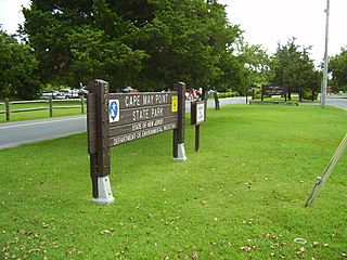
Cape May Point State Park (in Lower Township)
See also
 In Spanish: Cape May Point para niños


