Caazapá Department facts for kids
Quick facts for kids
Caazapá
Departamento de Caazapá
|
|||
|---|---|---|---|

|
|||
|
|||

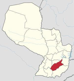
Location of Caazapá, in red, in Paraguay
|
|||
| Country | |||
| Region | Oriental | ||
| Capital | Caazapá | ||
| Boroughs | 10 (See list) | ||
| Area | |||
| • Total | 9,496 km2 (3,666 sq mi) | ||
| Population
(2012)
|
|||
| • Total | 151,415 | ||
| • Density | 15.9451/km2 (41.2977/sq mi) | ||
| Demonym(s) | Caazapeño | ||
| Time zone | UTC-04 (AST) | ||
| • Summer (DST) | UTC-03 (ADT) | ||
| ISO 3166 code | PY-06 | ||
| Website | Official website: http://www.gobcz.gov.py/portal/ | ||
The Caazapá department (Spanish: Departamento de Caazapá) is a department of Paraguay. The capital is the city of Caazapá. Its ISO 3166-2 code is PY-06.
Its name comes from Guarani ka´aguy jehasapá, that means "beyond the forest".
People from the department are calle Caazapeño (women: Caazapeña).
Geography
The Caazapá department is in the southeast of the Oriental region. It has an area of 9,496 km2 (3,666 sq mi). As of 2012[update], the department has a population of 151,415 (2.3% of the population of the country) for a population density of 15.9.
The Caaguazú mountain range crosses the department from east to west and divides the department in two regions: the northwestern region, with flat lands, and southeastern region, with small hills with forests.
The Tebicuary river flows from east to west in the south of the department; it serves as limit with the Itapúa department. The Tebicuary–mí river serves as limit with the Paraguarí department.
The protected areas in the department are the National park Caaguazú, the Golondrina Private Reserve and the Protected Wildlife Area Susu Island.
Limits
- To the north: Guairá and Caaguazú departments.
- To the east: Alto Paraná department.
- To the south: Itapúa department.
- To the west: Paraguarí and Misiones departments.
 |
Paraguarí | Guairá | Caaguazú |  |
| Alto Paraná | ||||
| Misiones | Itapúa |
Climate
As of 2012[update], the total amount of precipitation in the city of Caazapá was 1,408.6 mm (55.5 in). The month with the most precipitation was October with 144.3 mm (5.7 in) of precipitation. The month with the least precipitation was August with 37.8 mm (1.5 in).
The average temperature for the year 2012 in Caazapá was 22.6 °C (72.7 °F). The warmest month, on average, was January with an average temperature of 26.6 °C (79.9 °F). The coolest month on average is June, with an average temperature of 16.5 °C (61.7 °F).
Districts
The department is divided in 11 districts:
| No. | Districts | Area (km²) |
Population (2015) |
Density |
|---|---|---|---|---|
| 1 | Abaí | 2,144.30 | 31,722 | 14.8 |
| 2 | Buena Vista | 150.61 | 6,145 | 40.8 |
| 3 | Caazapá | 830.89 | 25,977 | 31.3 |
| 4 | Doctor Moisés S. Bertoni | 676.15 | 5,619 | 8.3 |
| 5 | Fulgencio Yegros | 977.59 | 6,819 | 7.0 |
| 6 | General Higinio Morínigo | 219.05 | 6,249 | 28.5 |
| 7 | Maciel | 427.63 | 4,743 | 11.1 |
| 8 | San Juan Nepomuceno | 945.00 | 35,725 | 37.8 |
| 9 | Tavaí | 1,233.05 | 17,558 | 14.2 |
| 10 | Yuty | 1,120.34 | 21,501 | 19.2 |
| 11 | 3 de Mayo | 732.71 | 17,518 | 23.9 |
Economy
Farming is the main economic activity in the department. The main crops are cotton and soybean. But cattle raising is the most important activity.
Related pages
See also
 In Spanish: Departamento de Caazapá para niños


