Brownstone Canyon Archaeological District facts for kids
Quick facts for kids |
|
|
Brownstone Canyon Archeological District
|
|

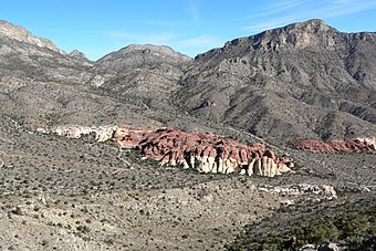
Brownstone Basin seen from Turtlehead Peak
|
|
| Lua error in Module:Location_map at line 420: attempt to index field 'wikibase' (a nil value). | |
| Location | Clark County, Nevada |
|---|---|
| Nearest city | Las Vegas, Nevada |
| NRHP reference No. | 82003212 |
| Added to NRHP | September 22, 1982 |
Brownstone Canyon Archaeological District comprises 2,920 acres (1,180 ha) and is located in the La Madre Mountain Wilderness Area which covers 47,180 acres (19,090 ha) in southern Nevada. The area is administered by the Humboldt-Toiyabe National Forest and the Bureau of Land Management and includes many petroglyphs.
History
The district was listed on the National Register of Historic Places on September 22, 1982 for its significance during the period of 1975–2000.

All content from Kiddle encyclopedia articles (including the article images and facts) can be freely used under Attribution-ShareAlike license, unless stated otherwise. Cite this article:
Brownstone Canyon Archaeological District Facts for Kids. Kiddle Encyclopedia.
