Bayet facts for kids
Quick facts for kids
Bayet
|
|
|---|---|
|
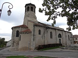
The Church of Saint Marcel
|
|
| Country | France |
| Region | Auvergne-Rhône-Alpes |
| Department | Allier |
| Arrondissement | Moulins |
| Canton | Saint-Pourçain-sur-Sioule |
| Intercommunality | Pays Saint-Pourcinois |
| Area
1
|
22.58 km2 (8.72 sq mi) |
| Time zone | UTC+01:00 (CET) |
| • Summer (DST) | UTC+02:00 (CEST) |
| INSEE/Postal code |
03018 /03500
|
| Elevation | 237–290 m (778–951 ft) (avg. 235 m or 771 ft) |
| 1 French Land Register data, which excludes lakes, ponds, glaciers > 1 km2 (0.386 sq mi or 247 acres) and river estuaries. | |
Bayet (Occitan, Baiet) is a French commune in the Allier department in the Auvergne-Rhône-Alpes region of central France.
The inhabitants of the commune are known as Bayétois or Bayétoises.
Geography
Bayet is located some 36 km (22 mi) south of Moulins and 18 km (11 mi) north-west of Vichy. Access to the commune is by the D2009 (former N9) road from Saint-Pourçain-sur-Sioule in the north which passes through the commune east of the village and continues south to Le Mayet-d'École. The D6 branches off the D2009 in the commune and goes south-east to Saint-Didier-la-Forêt. Access to the village is by the D406 which branches off the D2009 in the commune and goes south-west to the village changing to the D519. The D183 goes south from the village to Barberier. The D219 comes from Chareil-Cintrat in the west and passes through the village before continuing east to join the D6. The D35 from Étroussat in the south-west to Saint-Pourcain-sur-Sioule passes through the west of the commune. Apart from the village there are the hamlets of Nerignet, Le Marais, Les Echaloux, La Rue du Jo, Le Plaix, Le Chambon, and Les Bouillots. The commune is almost entirely farmland.
The railway line from La Ferté-Hauterive to Gannat once passed through the commune. It was the last line to have been commissioned by the Chemins de fer de Paris à Lyon et à la Méditerranée in 1932. It was closed to passenger traffic in 1938. The section between the stations of Saint-Pourçain-sur-Sioule and Bayet was closed to freight traffic in 1960 and decommissioned in 1969 followed by a path being created in 1974.
The Sioule river flows through the commune from south to north and continues north to join the Allier north-east of Contigny. The Bouble river flows from the west and through the western part of the commune as it flows north-east to join the Sioule on the commune border.


