Baarle-Hertog facts for kids
Quick facts for kids
Baarle-Hertog
|
|||
|---|---|---|---|

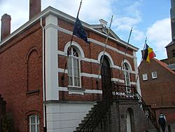
Former town hall
|
|||
|
|||
| Country | Belgium | ||
| Community | Flemish Community | ||
| Region | Flemish Region | ||
| Province | Antwerp | ||
| Arrondissement | Turnhout | ||
| Area | |||
| • Total | 7.48 km2 (2.89 sq mi) | ||
| Population
(2018-01-01)Lua error in Module:Wd at line 1575: attempt to index field 'wikibase' (a nil value).
|
|||
| • Total | Lua error in Module:Wd at line 1,575: attempt to index field 'wikibase' (a nil value). | ||
| Postal codes |
2387
|
||
| Area codes | 014 | ||
Baarle-Hertog (Dutch pronunciation: [ˌbaːrlə ˈɦɛrtɔx]; French: Baerle-Duc, pronounced [baʁl(ə)dyk]) is a Flemish municipality of Belgium, much of which consists of a number of small Belgian enclaves fully surrounded by the Netherlands.
Parts of Baarle-Hertog are surrounded by the Dutch province of North Brabant, but it is part of the Belgian province of Antwerp. As of 2021[update], it had a population of 2,935. The total area is 7.48 square kilometres (2.89 square miles).
Contents
Geography
Border with Baarle-Nassau
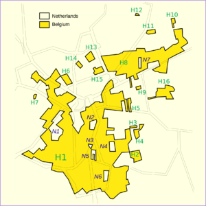
Baarle-Hertog is noted for its complicated borders with Baarle-Nassau, Netherlands.
The border's complexity results from a number of medieval treaties, agreements, land-swaps and sales between the Lords of Breda and the Dukes of Brabant. Generally speaking, predominantly agricultural or built environments became constituents of Brabant and other parts devolved to Breda. These distributions were ratified and clarified as a part of the border settlements agreed under the Treaty of Maastricht in 1843. The tight integration of the European Union and in particular the Schengen Agreement have made many of the practicalities of the situation substantially simpler since the 1990s.
In total, the municipality of Baarle-Hertog consists of 26 separate parcels of land. Four are linked to other Belgian municipalities, from west to east: the Baalbrugse Bemden, a strip of land along the Merkske, Zondereigen-Ginhoven and an area near Weelde-Station. The largest single section, Zondereigen (named after its main hamlet), is located within mainland Belgium on the contiguous Dutch-Belgian border (north of the town of Merksplas). In addition to this, there are 22 Belgian exclaves fully within the Netherlands. There are also seven Dutch enclaves within the Belgian exclaves (i.e., counter-exclaves) that are part of the territory of the Netherlands. Six of these Dutch enclaves are located within the largest Belgian exclave, and a seventh in the second-largest Belgian exclave. An eighth Dutch exclave is located near Ginhoven.
During the First World War, this situation meant that the Imperial German Army could not occupy these parts of Belgium without crossing the Netherlands, which the Dutch government did not allow. Thus, these pieces of Belgium became a place where refugees could safely stay. A clandestine radio transmitter was smuggled in and from there worked with the Belgian resistance. The Dutch government fenced off these areas and controlled access in or out of them, building a church and school for the Belgian people who were effectively stranded within the enclaves. This situation did not exist in the Second World War, as both countries were occupied by Nazi Germany.
Some houses in the town of Baarle-Hertog/Baarle-Nassau are divided between the two countries. At one time, according to Dutch laws, restaurants had to close earlier. For some restaurants on the border, this simply meant that the customers had to move to a table on the Belgian side. In 2020, restrictions due to the COVID-19 pandemic differed between the two countries; for instance, preventing a Belgian citizen living metres away from an open Dutch bar from patronising it.
Many fireworks shops are found in Baarle-Hertog, as Belgian laws controlling the sale of fireworks are more lenient than those of the Netherlands. Many Dutch tourists come to Baarle-Hertog to buy fireworks to celebrate the New Year.
Two villages in the municipality, Zondereigen and Ginhoven, are located in the main territory of Belgium.
-
Café in Baarle-Nassau, showing border between Belgium and the Netherlands
-
Church of Saint Remigius
List of enclaves
Netherlands enclaves
These are all part of Baarle-Nassau municipality.
Belgian enclaves
These are all part of Baarle-Hertog municipality, and are surrounded by Baarle-Nassau municipality (Netherlands).
Climate
| Climate data for Baarle-Hertog (1991−2020 normals) | |||||||||||||
|---|---|---|---|---|---|---|---|---|---|---|---|---|---|
| Month | Jan | Feb | Mar | Apr | May | Jun | Jul | Aug | Sep | Oct | Nov | Dec | Year |
| Mean daily maximum °C (°F) | 6.3 (43.3) |
7.4 (45.3) |
11.0 (51.8) |
15.4 (59.7) |
18.9 (66.0) |
21.6 (70.9) |
23.6 (74.5) |
23.4 (74.1) |
19.8 (67.6) |
15.1 (59.2) |
10.1 (50.2) |
6.7 (44.1) |
14.9 (58.8) |
| Daily mean °C (°F) | 3.6 (38.5) |
4.0 (39.2) |
6.8 (44.2) |
10.1 (50.2) |
13.8 (56.8) |
16.7 (62.1) |
18.7 (65.7) |
18.3 (64.9) |
15.1 (59.2) |
11.2 (52.2) |
7.1 (44.8) |
4.2 (39.6) |
10.8 (51.4) |
| Mean daily minimum °C (°F) | 0.9 (33.6) |
0.8 (33.4) |
2.6 (36.7) |
4.8 (40.6) |
8.7 (47.7) |
11.8 (53.2) |
13.8 (56.8) |
13.2 (55.8) |
10.3 (50.5) |
7.3 (45.1) |
4.1 (39.4) |
1.6 (34.9) |
6.7 (44.1) |
| Average precipitation mm (inches) | 75.8 (2.98) |
69.9 (2.75) |
59.3 (2.33) |
45.3 (1.78) |
62.3 (2.45) |
76.1 (3.00) |
84.5 (3.33) |
83.2 (3.28) |
71.7 (2.82) |
73.9 (2.91) |
83.6 (3.29) |
96.6 (3.80) |
882.2 (34.73) |
| Average precipitation days (≥ 1.0 mm) | 12.9 | 12.0 | 10.8 | 8.9 | 9.9 | 10.3 | 11.3 | 11.0 | 10.4 | 11.2 | 13.2 | 14.7 | 136.6 |
| Mean monthly sunshine hours | 63 | 81 | 136 | 190 | 217 | 215 | 220 | 205 | 162 | 117 | 69 | 53 | 1,726 |
| Source: Royal Meteorological Institute | |||||||||||||
Education
Baarle-Hertog has two elementary schools: De Vlinder and De Horizon.
It shares, with Baarle-Nassau, a joint library with Belgian and Dutch staff.
Notable inhabitants
- Petrus Christus, 15th-century painter
See also
 In Spanish: Baarle-Hertog para niños


