Arrondissement of Saint-Flour facts for kids
Quick facts for kids
Arrondissement of Saint-Flour
|
|
|---|---|

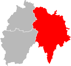
Location of Saint-Flour in Cantal
|
|
| Country | France |
| Region | Auvergne-Rhône-Alpes |
| Department | Cantal |
| Communes | 106 |
| Prefecture | Saint-Flour |
| INSEE code | 153 |
| Area | |
| • Total | 2,511 km2 (970 sq mi) |
| Population
(2014)
|
|
| • Total | 38,079 |
| • Density | 15.165/km2 (39.277/sq mi) |
The arrondissement of Saint-Flour is an arrondissement of France. It is part of the Cantal département in the Auvergne-Rhône-Alpes region. Its capital, and subpréfecture of the department, is the city of Saint-Flour.
History
When the arrondissements were created in 1800, Saint-Flour was one of them in the Cantal department.
Geography
The arrondissement of Saint-Flour is in the most eastern arrondissement of the department and has an area of 2,511 km2 (970 sq mi), the largest in the department, and a population of 38,079 inhabitants with a population density of 15.2 inhabitants/km².
The arrondissement is bordered to the north by the Puy-de-Dôme department, to the east by the Haute-Loire department, to the southeast by the Lozère department (Occitanie), to the southeast by the Aveyron department (Occitanie) and to the west by the arrondissements of Aurillac and Mauriac.
Composition
Cantons
After the reorganisation of the cantons in France, cantons are not subdivisions of the arrondissements so they could have communes that belong to different arrondissements.
In the arrondissement of Saint-Flour, there is only one canton where not all their "communes" are in the arrondissement: the Riom-ès-Montagnes. The following table shows the distribution of the "communes" in the cantons and arrondissements:
| INSEE Code |
Canton | Aurillac | Mauriac | Saint-Flour | Total |
|---|---|---|---|---|---|
| 1507 | Murat | 27 | 27 | ||
| 1509 | Neuvéglise | 28 | 28 | ||
| 1510 | Riom-ès-Montagnes | 14 | 9 | 23 | |
| 1511 | Saint-Flour-1 | 23 + part of Saint-Flour | 23 + part of Saint-Flour | ||
| 1512 | Saint-Flour-2 | 18 + part of Saint-Flour | 18 + part of Saint-Flour |
Communes
The arrondissement of Saint-Flour has 106 communes; they are (with their INSEE codes):
- Albepierre-Bredons (15025)
- Allanche (15001)
- Alleuze (15002)
- Andelat (15004)
- Anglards-de-Saint-Flour (15005)
- Anterrieux (15007)
- Auriac-l'Église (15013)
- Bonnac (15022)
- Brezons (15026)
- Celles (15031)
- Celoux (15032)
- Cézens (15033)
- Chaliers (15034)
- Chalinargues (15035)
- Chanterelle (15040)
- La Chapelle-d'Alagnon (15041)
- La Chapelle-Laurent (15042)
- Charmensac (15043)
- Chastel-sur-Murat (15044)
- Chaudes-Aigues (15045)
- Chavagnac (15047)
- Chazelles (15048)
- Cheylade (15049)
- Le Claux (15050)
- Clavières (15051)
- Coltines (15053)
- Condat (15054)
- Coren (15055)
- Cussac (15059)
- Deux-Verges (15060)
- Dienne (15061)
- Espinasse (15065)
- Ferrières-Saint-Mary (15069)
- Fridefont (15073)
- Gourdièges (15077)
- Jabrun (15078)
- Joursac (15080)
- Lacapelle-Barrès (15086)
- Landeyrat (15091)
- Lastic (15097)
- Laurie (15098)
- Lavastrie (15099)
- Laveissenet (15100)
- Laveissière (15101)
- Lavigerie (15102)
- Leyvaux (15105)
- Lieutadès (15106)
- Lorcières (15107)
- Lugarde (15110)
- Malbo (15112)
- Marcenat (15114)
- Marchastel (15116)
- Massiac (15119)
- Maurines (15121)
- Mentières (15125)
- Molèdes (15126)
- Molompize (15127)
- Montboudif (15129)
- Montchamp (15130)
- Montgreleix (15132)
- Murat (15138)
- Narnhac (15139)
- Neussargues-Moissac (15141)
- Neuvéglise (15142)
- Oradour (15145)
- Paulhac (15148)
- Paulhenc (15149)
- Peyrusse (15151)
- Pierrefort (15152)
- Pradiers (15155)
- Rageade (15158)
- Rézentières (15161)
- Roffiac (15164)
- Ruynes-en-Margeride (15168)
- Saint-Amandin (15170)
- Saint-Bonnet-de-Condat (15173)
- Sainte-Anastasie (15171)
- Sainte-Marie (15198)
- Saint-Flour (15187)
- Saint-Georges (15188)
- Saint-Martial (15199)
- Saint-Martin-sous-Vigouroux (15201)
- Saint-Mary-le-Plain (15203)
- Saint-Poncy (15207)
- Saint-Rémy-de-Chaudes-Aigues (15209)
- Saint-Saturnin (15213)
- Saint-Urcize (15216)
- Ségur-les-Villas (15225)
- Sériers (15227)
- Soulages (15229)
- Talizat (15231)
- Tanavelle (15232)
- Les Ternes (15235)
- Tiviers (15237)
- La Trinitat (15241)
- Ussel (15244)
- Vabres (15245)
- Val d'Arcomie (15108)
- Valjouze (15247)
- Valuéjols (15248)
- Védrines-Saint-Loup (15251)
- Vernols (15253)
- Vèze (15256)
- Vieillespesse (15259)
- Villedieu (15262)
- Virargues (15263)
The communes with more inhabitants in the arrondissement are:
| INSEE code |
Commune | Population (2014) |
Canton | Intercommunality |
|---|---|---|---|---|
| 15187 | Saint-Flour | 6,643 | Saint-Flour-1 and Saint-Flour-2 | Pays de Saint-Flour Margeride |
| 15138 | Murat | 1,880 | Murat | Pays de Murat |
| 15119 | Massiac | 1,735 | Saint-Flour-1 | Pays de Massiac |
| 15188 | Saint-Georges | 1,138 | Neuvéglise | Pays de Saint-Flour Margeride |
| 15142 | Neuvéglise | 1,104 | Neuvéglise | Pays de Pierrefort-Neuvéglise |
| 15054 | Condat | 1,031 | Riom-ès-Montagnes | Cézallier |
| 15108 | Val d'Arcomie | 1,005 | Neuvéglise | Pays de Saint-Flour Margeride |
| 15141 | Neussargues-Moissac | 1,004 | Murat | Pays de Murat |
Related pages
- Arrondissements of the Cantal department
- Communes of the Cantal department
- List of arrondissements of France
See also
 In Spanish: Distrito de Saint-Flour para niños

