Zapolyarny, Murmansk Oblast facts for kids
Quick facts for kids Zapolyarny (English)Заполярный (Russian) |
|
|---|---|
| - Town - | |
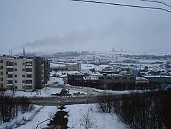
 View of Zapolyarny |
|
|
|
|
| Administrative status | |
| Country | Russia |
| Federal subject | Murmansk Oblast |
| Administrative district | Pechengsky District |
| Statistics | |
| Population (2010 Census, preliminary) |
15,825 inhabitants |
| Time zone | MSK (UTC+04:00) |
| Founded | 1956 |
| Town status since | February 1, 1963 |
| Postal code(s) | 184430 |
| Official website: https://pechengamr.gov-murman.ru/ | |
Zapolyarny (Russian: Заполя́рный; Norwegian: Zapoljarnyj) is a town in Pechengsky District of Murmansk Oblast, Russia, located on the Kola Peninsula, 10 kilometers (6.2 mi) northeast of the Kola Superdeep Borehole project. Population: 15,825 (2010 Census); 18,640 (2002 Census); 23,564 (1989 Census).
The area where the town is located belonged to Finland in 1920–1944. It was founded in 1956 as Zhdanovsk (Жда́новск) and was granted work settlement status and later given its present name.
On February 1, 1963, by the Decree by the Presidium of the Supreme Soviet of the RSFSR, Zapolyarny was elevated in status to that of a town of district significance.
It is the nearest town to the disused Koshka Yavr naval air station.
See also
 In Spanish: Zapoliarni para niños


