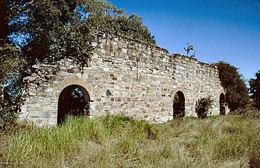
Yengarie, Queensland facts for kids
Quick facts for kids YengarieQueensland |
|||||||||||||||
|---|---|---|---|---|---|---|---|---|---|---|---|---|---|---|---|

Yengarie Sugar Refinery ruins, 2002
|
|||||||||||||||
| Population | 615 (2021 census) | ||||||||||||||
| • Density | 22.61/km2 (58.6/sq mi) | ||||||||||||||
| Postcode(s) | 4650 | ||||||||||||||
| Area | 27.2 km2 (10.5 sq mi) | ||||||||||||||
| Time zone | AEST (UTC+10:00) | ||||||||||||||
| LGA(s) | Fraser Coast Region | ||||||||||||||
| State electorate(s) | Maryborough | ||||||||||||||
| Federal Division(s) | Wide Bay | ||||||||||||||
|
|||||||||||||||
Yengarie is a rural locality in the Fraser Coast Region, Queensland, Australia. In the 2021 census, Yengarie had a population of 615 people.
History
Yengarie School opened on 30 March 1868 as a non-vested school (funded by the Queensland Government but not operated by the government). On 14 July 1873, it became Yenagarie State School (operated by the government). In 1873, it had 89 students and a new school building was being constructed to replace the old building described as "dilapidated and overcrowded". It closed in 1963. It was at 340 Old Mill Road (25°33′19″S 152°37′00″E / 25.55534°S 152.61673°E).
Demographics
In the 2016 census, Yengarie had a population of 460 people.
In the 2021 census, Yengarie had a population of 615 people.
Heritage listings
Yengarie has a number of heritage-listed sites, including:
- Central Sugar Mill Ruins, Old Mill Road
- Yengarie Sugar Refinery Ruins, Old Mill Road


