Yamanashi Prefecture facts for kids
Quick facts for kids Yamanashi Prefecture |
|||||||||
|
|||||||||
 |
|||||||||
| Capital | Kōfu | ||||||||
| Region | Chūbu | ||||||||
| Island | Honshū | ||||||||
| Governor | Shōmei Yokouchi | ||||||||
| Area (rank) | 4,465.38 km² (32nd) | ||||||||
| - % water | 1.3% | ||||||||
| Population (February 1, 2011) | |||||||||
| - Population | 861,431 (41st) | ||||||||
| - Density | 192.91 /km² | ||||||||
| Districts | 5 | ||||||||
| Municipalities | 27 | ||||||||
| ISO 3166-2 | JP-19 | ||||||||
| Website | pref.yamanashi.jp | ||||||||
| Prefectural Symbols | |||||||||
| - Flower | Fujizakura (Sakura) | ||||||||
| - Tree | Kaede (Japanese Maple) | ||||||||
| - Bird | Uguisu (Bush Warbler) | ||||||||
| - Fish | |||||||||
 Symbol of Yamanashi Prefecture |
|||||||||
Yamanashi Prefecture (山梨県, Yamanashi-ken) is a prefecture in the Chūbu region of Japan on the island of Honshū. The capital is the city of Kōfu.
Contents
History
During the Heian period, Kai Province was created in this area and it was re-named Yamanashi in the Meiji period.
Timeline
- 1869 – Kai Province was renamed Kōfu Prefecture
- 1871 – Kōfu was renamed Yamanashi Prefecture.
Geography
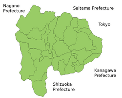
The borders of Yamanashi Prefecture are formed by Tokyo Prefecture, Kanagawa Prefecture, Saitama Prefecture, Shizuoka Prefecture, and Nagano Prefecture.
The prefecture is landlocked with mountains surrounding the central Kōfu Basin.
Mount Fuji is on the southern border with Shizuoka.
Cities
|
|
Towns and Villages
Towns and villages in each district:
|
|
National Parks
National Parks are established in about 27% of the total land area of the prefecture.
Shrines and Temples
Asama jinja is the chief Shinto shrine (ichinomiya) in the prefecture.
Takeda jinja is related to "Takeda Shingen".
Related pages
- Provinces of Japan
- Prefectures of Japan
- List of regions of Japan
- List of islands of Japan
- Ventforet Kofu
Images for kids
-
Mount Fuji from the Misaka Pass, Yamanashi
-
Yamanashi Chuo Bank Stadium in Kōfu.
See also
 In Spanish: Prefectura de Yamanashi para niños


