Wunjunga, Queensland facts for kids
Quick facts for kids WunjungaQueensland |
|||||||||||||||
|---|---|---|---|---|---|---|---|---|---|---|---|---|---|---|---|

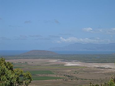
Wunjunga viewed from Mount Inkerman, Nov 2005
|
|||||||||||||||
| Population | 13 (2021 census) | ||||||||||||||
| • Density | 0.183/km2 (0.47/sq mi) | ||||||||||||||
| Postcode(s) | 4806 | ||||||||||||||
| Area | 71.1 km2 (27.5 sq mi) | ||||||||||||||
| Location |
|
||||||||||||||
| LGA(s) | Shire of Burdekin | ||||||||||||||
| State electorate(s) | Burdekin | ||||||||||||||
| Federal Division(s) | Dawson | ||||||||||||||
|
|||||||||||||||
Wunjunga is a coastal locality in the Shire of Burdekin in Queensland, Australia. In the 2021 census, Wunjunga had a population of 13 people.
Geography
Wunjunga is located south of Home Hill in North Queensland. The waters of the Coral Sea form the eastern boundary.
The Bruce Highway runs along the western boundary.
Demographics
In the 2016 census, Wunjunga had a population of 9 people.
In the 2021 census, Wunjunga had a population of 13 people.

All content from Kiddle encyclopedia articles (including the article images and facts) can be freely used under Attribution-ShareAlike license, unless stated otherwise. Cite this article:
Wunjunga, Queensland Facts for Kids. Kiddle Encyclopedia.


