Wrightstown, New Jersey facts for kids
Quick facts for kids
Wrightstown, New Jersey
|
||
|---|---|---|
|
Borough
|
||

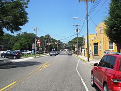
Center of the borough along East Main Street (CR 616)
|
||
|
||
| Motto(s):
"Gateway to Freedom"
|
||

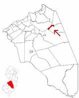
Wrightstown highlighted in Burlington County. Inset map: Burlington County highlighted in the State of New Jersey.
|
||

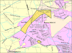
Census Bureau map of Wrightstown, New Jersey
|
||
| Country | ||
| State | ||
| County | ||
| Incorporated | March 26, 1918 | |
| Government | ||
| • Type | Borough | |
| • Body | Borough Council | |
| Area | ||
| • Total | 1.85 sq mi (4.79 km2) | |
| • Land | 1.85 sq mi (4.79 km2) | |
| • Water | 0.00 sq mi (0.00 km2) 0.00% | |
| Area rank | 423rd of 565 in state 33rd of 40 in county |
|
| Elevation | 151 ft (46 m) | |
| Population
(2020)
|
||
| • Total | 720 | |
| • Estimate
(2023)
|
722 | |
| • Rank | 546th of 565 in state 38th of 40 in county |
|
| • Density | 389.1/sq mi (150.2/km2) | |
| • Density rank | 460th of 565 in state 32nd of 40 in county |
|
| Time zone | UTC−05:00 (Eastern (EST)) | |
| • Summer (DST) | UTC−04:00 (Eastern (EDT)) | |
| ZIP Code |
08562
|
|
| Area code(s) | 609 exchanges: 723, 724, 752, 758 | |
| FIPS code | 3400582960 | |
| GNIS feature ID | 0885453 | |
| Website | ||
Wrightstown is a borough in Burlington County, in the U.S. state of New Jersey. As of the 2020 United States census, the borough's population was 720, a decrease of 82 (−10.2%) from the 2010 census count of 802, which in turn reflected an increase of 54 (+7.2%) from the 748 counted in the 2000 census.
Wrightstown was incorporated as a borough by an act of the New Jersey Legislature on March 4, 1918, from portions of New Hanover Township and North Hanover Township, based on the results of a referendum held on March 26, 1918. The borough was named for John Wright, an early settler who contributed the land that became the settlement of Wrightstown.
Contents
Geography
According to the U.S. Census Bureau, the borough had a total area of 1.85 square miles (4.79 km2), all of which was land.
The borough borders the Burlington County municipalities of New Hanover Township, North Hanover Township, Pemberton Township, and Springfield Township, as well as the McGuire AFB and Fort Dix entities of Joint Base McGuire-Dix-Lakehurst.
The borough is one of 56 South Jersey municipalities that are included within the New Jersey Pinelands National Reserve, a protected natural area of unique ecology covering 1,100,000 acres (450,000 ha), that has been classified as a United States Biosphere Reserve and established by Congress in 1978 as the nation's first National Reserve. Part of the borough is included in the state-designated Pinelands Area, which includes portions of Burlington County, along with areas in Atlantic, Camden, Cape May, Cumberland, Gloucester and Ocean counties.
Demographics
| Historical population | |||
|---|---|---|---|
| Census | Pop. | %± | |
| 1920 | 270 | — | |
| 1930 | 176 | −34.8% | |
| 1940 | 241 | 36.9% | |
| 1950 | 1,199 | 397.5% | |
| 1960 | 4,846 | 304.2% | |
| 1970 | 2,719 | −43.9% | |
| 1980 | 3,031 | 11.5% | |
| 1990 | 3,843 | 26.8% | |
| 2000 | 746 | −80.6% | |
| 2010 | 802 | 7.5% | |
| 2020 | 720 | −10.2% | |
| 2023 (est.) | 722 | −10.0% | |
| Population sources: 1920–2000 1920 1920–1930 1940–2000 1960–2000 2000 2010 2020 |
|||
Jozsef A. Farago, a former mayor of Wrightstown, criticized the 2000 Census data that showed that the borough's population had dropped 80%, to 748 from 3,843 a decade earlier, noting that the 1990 population had been inflated and that the conversion of Fort Dix to a reserve base had caused a decrease but that the borough's master plan showed a population of 838.
2010 census
The 2010 United States census counted 802 people, 309 households, and 189 families in the borough. The population density was 453.6 per square mile (175.1/km2). There were 348 housing units at an average density of 196.8 per square mile (76.0/km2). The racial makeup was 47.38% (380) White, 21.07% (169) Black or African American, 0.75% (6) Native American, 5.99% (48) Asian, 0.37% (3) Pacific Islander, 18.70% (150) from other races, and 5.74% (46) from two or more races. Hispanic or Latino of any race were 28.05% (225) of the population.
Of the 309 households, 34.3% had children under the age of 18; 28.8% were married couples living together; 21.7% had a female householder with no husband present and 38.8% were non-families. Of all households, 28.5% were made up of individuals and 5.2% had someone living alone who was 65 years of age or older. The average household size was 2.60 and the average family size was 3.17.
26.9% of the population were under the age of 18, 14.1% from 18 to 24, 28.8% from 25 to 44, 22.3% from 45 to 64, and 7.9% who were 65 years of age or older. The median age was 29.9 years. For every 100 females, the population had 109.9 males. For every 100 females ages 18 and older there were 110.8 males.
The Census Bureau's 2006–2010 American Community Survey showed that (in 2010 inflation-adjusted dollars) median household income was $40,096 (with a margin of error of +/− $4,881) and the median family income was $38,438 (+/− $7,242). Males had a median income of $37,917 (+/− $22,280) versus $34,167 (+/− $13,020) for females. The per capita income for the borough was $24,231 (+/− $4,722). About 15.2% of families and 17.2% of the population were below the poverty line, including 31.6% of those under age 18 and none of those age 65 or over.
Education
Students in public school for grades pre-kindergarten through eighth grade attend the New Hanover Township School District, a consolidated public school district that serves students from both New Hanover Township and Wrightstown. As of the 2018–19 school year, the district, comprised of one school, had an enrollment of 177 students and 23.6 classroom teachers (on an FTE basis), for a student–teacher ratio of 7.5:1. In the 2016–17 school year, the district had the 40th-smallest enrollment of any school district in the state.
For ninth through twelfth grades, public school students from both New Hanover Township and Wrightstown Borough attend Bordentown Regional High School as part of a sending/receiving relationship. The high school is part of the Bordentown Regional School District, a regional K–12 school district that serves students from Bordentown City, Bordentown Township and Fieldsboro Borough. As of the 2018–19 school year, the high school had an enrollment of 770 students and 53.8 classroom teachers (on an FTE basis), for a student–teacher ratio of 14.3:1. Students from Wrightstown, and from all of Burlington County, are eligible to attend the Burlington County Institute of Technology, a countywide public school district that serves the vocational and technical education needs of students at the high school and post-secondary level at its campuses in Medford Township and Westampton Township.
Economy and environmental protection
National concrete products supplier EP Henry operates a plant in Wrightstown. In 2019, it became the first customer for a reduced CO2 cement which reduces carbon emissions by 70%.
Transportation
Roads and highways
As of May 2010[update], the borough had a total of 4.35 miles (7.00 km) of roadways, of which 2.70 miles (4.35 km) were maintained by the municipality, 1.18 miles (1.90 km) by Burlington County and 0.47 miles (0.76 km) by the New Jersey Department of Transportation.
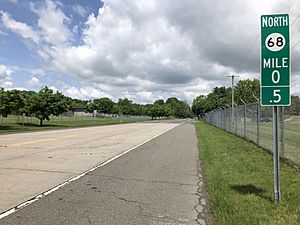
The most significant highway serving Wrightstown is New Jersey Route 68. County Route 545 also passes through the borough.
Public transportation
NJ Transit provides bus service in the borough on the 317 route between Asbury Park and Philadelphia.
News coverage
Wrightstown and neighboring Cookstown were put in the national spotlight when six Islamic militants, dubbed "The Fort Dix Six", were arrested while trying to carry out an attack against Fort Dix on May 7, 2007. Heightened security around the bases affected the local economy based heavily in restaurants specializing in delivery to the base.
Notable people
People who were born in, residents of, or otherwise closely associated with Wrightstown include:
- Daniel V. Asay (1847–1930), iceboat racer
- Samuel G. Wright (1781–1845), represented New Jersey's 2nd congressional district in 1845
See also
 In Spanish: Wrightstown (Nueva Jersey) para niños


