Winstanley, Greater Manchester facts for kids
Quick facts for kids Winstanley |
|
|---|---|
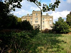
 Winstanley Hall |
|
| Population | 11,264 (2011 Census) |
| OS grid reference | SD531051 |
| Metropolitan borough |
|
| Metropolitan county | |
| Region | |
| Country | England |
| Sovereign state | United Kingdom |
| Post town | WIGAN |
| Postcode district | WN3 |
| Dialling code | 01942 |
| Police | Greater Manchester |
| Fire | Greater Manchester |
| Ambulance | North West |
| EU Parliament | North West England |
| UK Parliament |
|
Winstanley is a suburb of Wigan in the Metropolitan Borough of Wigan, in Greater Manchester, England. Historically in Lancashire, the area had a population of 15,849, reducing at the 2011 census to 11,264.
Transport
Train services to Wigan, Manchester and Kirkby are available at the nearby Pemberton railway station. The main road in the Winstanley area is the A571 (St.Helens to Wigan). Nearby is the A49, which gives access to the M6 motorway.
Local schools
- Highfield St. Matthew's CofE Primary School
- Marus Bridge Primary School
- St. Aidan's Catholic Primary School, Wigan
- Winstanley Community Primary School
- Winstanley College
- Hawkley Hall High School
Adjacent places

All content from Kiddle encyclopedia articles (including the article images and facts) can be freely used under Attribution-ShareAlike license, unless stated otherwise. Cite this article:
Winstanley, Greater Manchester Facts for Kids. Kiddle Encyclopedia.

