Windermere, Queensland facts for kids
Quick facts for kids WindermereQueensland |
|||||||||||||||
|---|---|---|---|---|---|---|---|---|---|---|---|---|---|---|---|

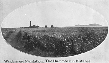
Windermere Mill with the Hummock in the background, 1907
|
|||||||||||||||
| Population | 188 (2021 census) | ||||||||||||||
| • Density | 15.67/km2 (40.6/sq mi) | ||||||||||||||
| Postcode(s) | 4670 | ||||||||||||||
| Area | 12.0 km2 (4.6 sq mi) | ||||||||||||||
| Time zone | AEST (UTC+10:00) | ||||||||||||||
| LGA(s) | Bundaberg Region | ||||||||||||||
| State electorate(s) | Burnett | ||||||||||||||
| Federal Division(s) | Hinkler | ||||||||||||||
|
|||||||||||||||
Windermere is a rural locality in the Bundaberg Region, Queensland, Australia. In the 2021 census, Windermere had a population of 188 people.
Geography
Pemberton is a neighbourhood in the south of the locality (24°52′00″S 152°27′00″E / 24.8666°S 152.45°E).
History
Windermere State School opened on 1922 and closed on circa 1942.
Barolin Provisional School opened in 1884. On 1 November 1886 it became Barolin State School. It closed in 1974. It was located 14 School Lane (24°52′02″S 152°26′48″E / 24.8672°S 152.4467°E) on the north-west corner of its intersection with Elliott Heads Road.
In 1995, the Coral Coast Christian Church congregation was established from the Bundaberg Baptist Church. In 2000 the church building was erected.
Demographics
In the 2016 census Windermere had a population of 184 people.
In the 2021 census, Windermere had a population of 188 people.
Heritage listings
Windermere has a number of heritage-listed sites, including:
- 94 Windermere Road: Sunnyside Sugar Plantation
Amenities
Coral Coast Christian Church is at 596 Windermere Road (24°50′57″S 152°27′42″E / 24.8491°S 152.4617°E).


