Willow Vale, Queensland facts for kids
Quick facts for kids Willow ValeGold Coast City, Queensland |
|||||||||||||||
|---|---|---|---|---|---|---|---|---|---|---|---|---|---|---|---|

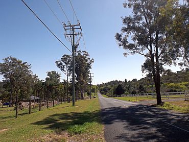
Hotham Creek Road
|
|||||||||||||||
| Population | 2,279 (2021 census) | ||||||||||||||
| • Density | 106.00/km2 (274.5/sq mi) | ||||||||||||||
| Postcode(s) | 4209 | ||||||||||||||
| Area | 21.5 km2 (8.3 sq mi) | ||||||||||||||
| Time zone | AEST (UTC+10:00) | ||||||||||||||
| LGA(s) | City of Gold Coast | ||||||||||||||
| State electorate(s) | Coomera | ||||||||||||||
| Federal Division(s) | Forde | ||||||||||||||
|
|||||||||||||||
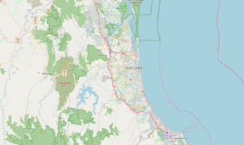
Willow Vale is a rural locality in the City of Gold Coast, Queensland, Australia. In the 2021 census, Willow Vale had a population of 2,279 people.
History
Before the official naming of this locality, the area was generally referred to as Pimpama.
Demographics
In the 2016 census, Willow Vale had a population of 2,096 people.
In the 2021 census, Willow Vale had a population of 2,279 people.
Heritage listings
Heritage listings at Willow Vale include:
- 105 Ruffles Road: Laurel Hill Farmhouse
Education
There are no schools in Willow Vale. The nearest government primary schools are Pimpama State School in neighbouring Pimpama to the north, Coomera Spring State School in neighbouring Upper Coomera to the east, and Upper Coomera State College in neighbouring Upper Coomera to the south-east. The nearest government secondary schools are Pimpama State Secondary College in Pimpama to the north-east and Upper Coomera State College in neighbouring Upper Coomera to the south-east.
Amenities
There are a number of parks in the area:
- Blacks Road Parklands 1 (27°50′18″S 153°15′16″E / 27.8384°S 153.2544°E)
- Blacks Road Parklands 2 (27°50′23″S 153°15′16″E / 27.8398°S 153.2545°E)
- Coulter Road Reserve (27°50′41″S 153°17′04″E / 27.8448°S 153.2845°E)
- Crystal Creek Reserve (27°51′04″S 153°15′50″E / 27.8510°S 153.2638°E)
- Galt Road Park (27°51′33″S 153°15′44″E / 27.8592°S 153.2621°E)
- Gerrale Dr Reserve 1 (27°49′55″S 153°15′05″E / 27.8319°S 153.2513°E)
- Gerrale Dr Reserve 2 (27°50′00″S 153°14′54″E / 27.8334°S 153.2484°E)
- Gerrale Dr Reserve 3 (27°50′08″S 153°14′47″E / 27.8355°S 153.2465°E)
- Heritage Park (27°49′49″S 153°17′19″E / 27.8302°S 153.2887°E)
- Hotham Ruffles Reserve (27°52′06″S 153°16′20″E / 27.8683°S 153.2721°E)
- Lower Galt Road Reserve (27°51′23″S 153°16′12″E / 27.8563°S 153.2700°E)
- Peanba Park (27°51′20″S 153°16′47″E / 27.8556°S 153.2796°E)
- Pittas Place Reserve (27°50′55″S 153°15′43″E / 27.8486°S 153.2619°E)
- Richardson Family Park (27°50′20″S 153°15′17″E / 27.8389°S 153.2548°E)
- Ruffles Rd Reserve (27°50′53″S 153°16′38″E / 27.8480°S 153.2772°E)
- Rufous Whistler Park (27°49′24″S 153°16′49″E / 27.8233°S 153.2802°E)
- The Dell Park (27°50′39″S 153°14′56″E / 27.8443°S 153.2488°E)
- The Grange Common (27°50′29″S 153°15′05″E / 27.8415°S 153.2513°E)
- The Grange Environmental Park (27°50′28″S 153°14′16″E / 27.8412°S 153.2377°E)
- Willowvale Reserve (27°51′47″S 153°16′27″E / 27.8630°S 153.2742°E)
- Wongawallan Reserve (27°52′07″S 153°15′22″E / 27.8687°S 153.2560°E)


