Williamstown, Missouri facts for kids
Quick facts for kids
Williamstown, Missouri
|
|
|---|---|
|
Census-Designated Place
|
|

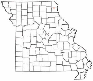
Location of Williamstown in Missouri
|
|
| Country | United States |
| State | Missouri |
| County | Lewis |
| Area | |
| • Total | 0.27 sq mi (0.70 km2) |
| • Land | 0.27 sq mi (0.70 km2) |
| • Water | 0.00 sq mi (0.00 km2) |
| Elevation | 725 ft (221 m) |
| Population
(2020)
|
|
| • Total | 60 |
| • Density | 221.40/sq mi (85.38/km2) |
| FIPS code | 29-80008 |
| GNIS feature ID | 2806411 |
Williamstown is an unincorporated community in northern Lewis County, Missouri, United States. It is located at the intersection of Missouri Supplemental Routes A and E, approximately twenty miles northwest of Canton. The community is part of the Quincy, IL–MO Micropolitan Statistical Area.
History
Williamstown was laid out in 1856. The community was named for its founder, Minus Williams.
Demographics
| Historical population | |||
|---|---|---|---|
| Census | Pop. | %± | |
| 2020 | 60 | — | |
| U.S. Decennial Census | |||
Notable people
- Elbert K. Fretwell educator

All content from Kiddle encyclopedia articles (including the article images and facts) can be freely used under Attribution-ShareAlike license, unless stated otherwise. Cite this article:
Williamstown, Missouri Facts for Kids. Kiddle Encyclopedia.
