Whiskey Island (Lake Michigan) facts for kids

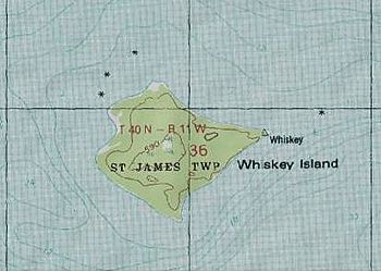
Topographic map
|
|
|
Whiskey Island (Michigan)
|
|
| Geography | |
|---|---|
| Location | Lake Michigan |
| Coordinates | 45°48′40″N 85°36′40″W / 45.81111°N 85.61111°W |
| Area | 0.375 sq mi (0.97 km2) |
| Highest elevation | 594 ft (181.1 m) |
| Administration | |
| State | Michigan |
| County | Charlevoix County |
| Township | St. James Township |
| Demographics | |
| Population | Uninhabited |
Whiskey Island is an island in northern Lake Michigan, part of the Beaver Island archipelago. It is about ⅜ of a square mile (1.0 km2.) in size. Although unininhabited, it is politically part of St. James Township, Charlevoix County, Michigan
The island is also called Whisky Island.
A shoal off the island was the site of the loss of the schooner Chandler J. Wells on 20 November 1884. She was carrying lumber from Manistique, Michigan to Buffalo, New York.

All content from Kiddle encyclopedia articles (including the article images and facts) can be freely used under Attribution-ShareAlike license, unless stated otherwise. Cite this article:
Whiskey Island (Lake Michigan) Facts for Kids. Kiddle Encyclopedia.

