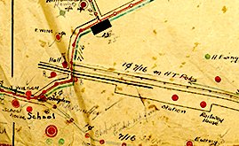
Whangarata railway station facts for kids
Whangarata railway station was a station on the North Island Main Trunk, and in the Waikato region of New Zealand. It was originally known as Wangarata.
The station was opened on 20 May 1875, and was closed on 3 October 1966.
Whangarata was a flag station, 37 mi (60 km) south of Auckland. It was on a steep gradient, 618.4 km (384.3 mi) north of Wellington, 3.17 km (1.97 mi) east of Tuakau, 4.28 km (2.66 mi) west of Pokeno and 60 m (200 ft) above sea level.
A deviation in 1914 allowed for an easier curve and gradient.
| Preceding station | Following station | |||
|---|---|---|---|---|
| Tuakau Line open, station closed |
North Island Main Trunk New Zealand Railways Department |
Pokeno Line open, station closed |
||

All content from Kiddle encyclopedia articles (including the article images and facts) can be freely used under Attribution-ShareAlike license, unless stated otherwise. Cite this article:
Whangarata railway station Facts for Kids. Kiddle Encyclopedia.

