West Laurel, Maryland facts for kids
Quick facts for kids
West Laurel, Maryland
|
|
|---|---|

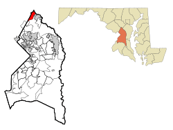
Location of West Laurel, Maryland (using 1990 and 2000 Census Bureau boundaries)
|
|
| Country | |
| State | |
| County | |
| Area | |
| • Total | 2.36 sq mi (6.13 km2) |
| • Land | 2.26 sq mi (5.86 km2) |
| • Water | 0.10 sq mi (0.26 km2) |
| Elevation | 351 ft (107 m) |
| Population
(2020)
|
|
| • Total | 4,428 |
| • Density | 1,956.69/sq mi (755.35/km2) |
| Time zone | UTC−5 (Eastern (EST)) |
| • Summer (DST) | UTC−4 (EDT) |
| FIPS code | 24-83025 |
| GNIS feature ID | 1867305 |
West Laurel is an unincorporated area and census-designated place (CDP) in Prince George's County, Maryland, United States. Per the 2020 census, the population was 4,428.
Contents
History
As of the 2010 U.S. Census some areas previously defined by the U.S. Census Bureau as "West Laurel" were put in a new CDP, Konterra.
Geography
West Laurel is located at 39°6′32″N 76°53′37″W / 39.10889°N 76.89361°W (39.108858, −76.893486).
According to the United States Census Bureau, the CDP has a total area of 2.4 square miles (6.2 km2), of which 2.3 square miles (5.9 km2) is land and 0.1 square miles (0.3 km2), or 4.29%, is water.
Demographics
| Historical population | |||
|---|---|---|---|
| Census | Pop. | %± | |
| 2010 | 4,230 | — | |
| 2020 | 4,428 | 4.7% | |
| U.S. Decennial Census 2010 2020 |
|||
2020 census
| Race / Ethnicity (NH = Non-Hispanic) | Pop 2010 | Pop 2020 | % 2010 | % 2020 |
|---|---|---|---|---|
| White alone (NH) | 2,754 | 2,294 | 65.11% | 51.81% |
| Black or African American alone (NH) | 686 | 796 | 16.22% | 17.98% |
| Native American or Alaska Native alone (NH) | 4 | 3 | 0.09% | 0.07% |
| Asian alone (NH) | 205 | 316 | 4.85% | 7.14% |
| Pacific Islander alone (NH) | 1 | 0 | 0.02% | 0.00% |
| Some Other Race alone (NH) | 16 | 24 | 0.38% | 0.54% |
| Mixed Race or Multi-Racial (NH) | 108 | 261 | 2.55% | 5.89% |
| Hispanic or Latino (any race) | 456 | 734 | 10.78% | 16.58% |
| Total | 4,230 | 4,428 | 100.00% | 100.00% |
Education
West Laurel CDP is served by schools in the Prince George's County Public Schools.
Zoned schools serving sections of the CDP include Bond Mill Elementary School in West Laurel, Martin Luther King Middle School in Beltsville, and Laurel High School in Laurel.
See also
 In Spanish: West Laurel para niños

