West Coyote Hills facts for kids
Quick facts for kids West Coyote Hills |
|
|---|---|

cliffs in Coyote Hills
|
|
| Highest point | |
| Elevation | 184 m (604 ft) |
| Geography | |
| Country | United States |
| State | California |
| District | Orange County |
| Range coordinates | 33°54′19.050″N 117°57′44.224″W / 33.90529167°N 117.96228444°W |
| Topo map | USGS La Habra |
The West Coyote Hills are a low mountain range in northern Orange County, California. It contains one of the last large open-space area in north Orange County. Parts of it lie within the city limits of La Habra, Buena Park, and La Mirada, with most of it sprawling across western Fullerton between Ralph B. Clark Regional Park and Euclid Street north of Rosecrans Avenue. The foothill region to the east and south is known as Sunny Hills. There is also an East Coyote Hills area, on the east side of Fullerton, that has been almost completely developed for residential real estate.
The remaining open-space area is currently the subject of a long-running dispute over residential development, pitting conservationists against a pro-development majority on the city council. A division of Chevron is currently proposing to develop the portions of the land that are suitable for development, while leaving the remainder as open space.
Contents
Name
The hills received their name from the nearby Rancho Los Coyotes; by the 1870s they were being called Coyote Hills. The name is appropriate, since coyotes do inhabit the area.
Plant life
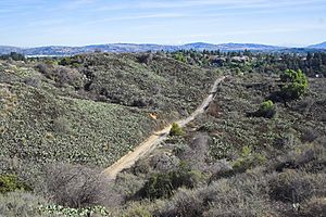
The undeveloped areas of Coyote Hills are vegetated with coastal sage scrub. Native species include buckwheat and prickly pear. Nonnative plants include pepper trees, tobacco trees, and mustard. There are no creeks, except for ephemeral freshets after storms, and no native riparian species such as oaks. Mature eucalyptus trees and some pine trees grow along some of the fence lines, where the area abuts housing tracts and the city's trail system.
Topography
The area has been modified by large earth-moving projects to reduce the number of steep hills and canyons, allowing Gilbert Street to be constructed and real estate developments and later a golf course to be built on the west side of Gilbert. East of Gilbert Street, the undeveloped area consists mainly of a large, sun-exposed, gentle north-facing slope. The larger area west of Gilbert contains rugged terrain, predominantly south-facing slopes, and a large, long, dry, flat-bottomed canyon that runs north-south. The canyon bottom has been paved, and provides a fire road accessible from the nearby fire station on Rosecrans Avenue. The steep sides of the canyon were terraced and networked with asphalt roads for oil drilling. Impressive cliffs are a landmark visible to motorists on Rosecrans Avenue.
Fossils
U.S. Geological Survey researchers have found invertebrate fossils representing 184 taxa from 158 localities in the "San Pedro" Formation in the Coyote Hills, including various species of annelids, mollusks, arthropods, and echinoids; the fossils suggest a late Pliocene to early Pleistocene age for outcrops of the formation. The occurrence of the bivalve Solamen columbianum in the area marks its first occurrence as a fossil. The oldest fossil occurrence of the gastropods Tegula pulligo (Gmelin), questionably Haliotis cracherodii, and the crustacean Randallia ornata occur in the "San Pedro" Formation in the Coyote Hills.
Risner fire
A brush fire, the Risner fire, originated at a transient encampment in the area. It burned about 80 acres on September 8 and 9, 2015, prompting the evacuation of about 40 nearby homes.


