Watersheds of Indiana facts for kids
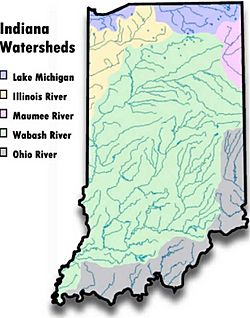
The Watersheds of Indiana consist of six distinct Indiana watershed regions that drain into five major bodies of water.

Contents
Illinois River watershed
With the Kankakee River, the Illinois River watershed stretches from the Illinois border in northwest Indiana and up into Michigan's Berrien County, adjacent to St. Joseph County.
This drainage area include most of the state known as the Northwest Indiana, including the city of La Porte but excluding the area north of the Valparaiso Moraine which drains into Lake Michigan.
Lake Michigan watersheds
There are two watersheds in the state that drain into Lake Michigan. In the northwest part of the state, it includes the Grand Calumet River area in Lake and Porter counties, and includes the cities of Gary and Hammond. This watershed is defined by the Valparaiso Moraine.
The second, and larger Lake Michigan watershed is the St. Joseph River watershed, which drains the north central and northeastern part of the state. It includes the cities of South Bend, Elkhart, Mishawaka and Goshen.
Maumee River watershed
The smallest watershed in the state is the Maumee River watershed in the northeast part of the state on the border with Ohio. It includes most of the city of Fort Wayne as well as the cities of New Haven, Woodburn, and Auburn. The Maumee eventually empties into Lake Erie at Toledo, Ohio.
Ohio River watershed
The Ohio River watershed includes the extreme southern part of the state as well as the extreme southwestern Indiana counties. This drainage area includes the cities of Evansville, Richmond and New Albany as well as the Indiana suburbs of Cincinnati, Ohio.
Wabash River watershed
By far the largest watershed in the state, the Wabash River drainage area contains the several large cities, including Indianapolis and the extreme western part of Fort Wayne. Other cities included in the area are Bloomington, Muncie, Lafayette, Anderson and Terre Haute. This watershed also includes most of Indiana's prime farm land. The area within the Lower Wabash Valley is also known as "Watermelon Country", largely due to its sandy soil on which watermelons and cantaloupes thrive. Cities within this area include Vincennes, Sullivan. Many towns of this area have "Watermelon Festivals" such as Owensville, Poseyville and Vincennes (Knox County) usually at harvest time (first weeks of August).

