Watauga County, North Carolina facts for kids
Quick facts for kids
Watauga County
|
||
|---|---|---|

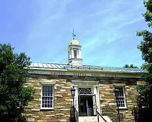
United States Post Office in Boone
|
||
|
||

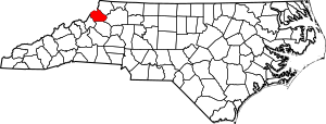
Location within the U.S. state of North Carolina
|
||
 North Carolina's location within the U.S. |
||
| Country | ||
| State | ||
| Founded | 1849 | |
| Named for | Watauga River | |
| Seat | Boone | |
| Largest community | Boone | |
| Area | ||
| • Total | 313.32 sq mi (811.5 km2) | |
| • Land | 312.44 sq mi (809.2 km2) | |
| • Water | 0.88 sq mi (2.3 km2) 0.28% | |
| Population
(2020)
|
||
| • Total | 54,086 | |
| • Estimate
(2023)
|
54,748 | |
| • Density | 173.11/sq mi (66.84/km2) | |
| Time zone | UTC−5 (Eastern) | |
| • Summer (DST) | UTC−4 (EDT) | |
| Congressional district | 5th | |
Watauga County (/wəˈtɔːɡə/ wuh-TAW-guh) is a county located in the U.S. state of North Carolina. As of the 2020 census, the population was 54,086. Its county seat and largest community is Boone. The county is in an exceptionally mountainous region, known as the High Country. It is the home of Appalachian State University, which has approximately 21,570 students as of Fall 2024. Watauga County comprises the Boone, NC Micropolitan Statistical Area.
Contents
History
The county was formed in 1849 from parts of Ashe, Caldwell, Wilkes, and Yancey counties. It was named for the Watauga River, whose name is said to be a Native American word. Meanings include "beautiful water," "whispering waters," "village of many springs," and "river of islands."
Geography
According to the U.S. Census Bureau, the county has a total area of 313.32 square miles (811.5 km2), of which 312.44 square miles (809.2 km2) is land and 0.88 square miles (2.3 km2) (0.28%) is water.
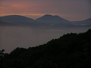
Watauga County is extremely mountainous, and all of the county's terrain is located within the Appalachian Mountains range. The highest point in the county is Calloway Peak, the highest peak of Grandfather Mountain (shared with the adjacent counties of Avery and Caldwell), which rises to 5,964 feet (1,818 meters) above sea level. At an elevation of 5,506 feet (1,678 meters) above sea level, Beech Mountain is the highest incorporated community east of the Mississippi River. Boone, the county's largest city and county seat, has the highest elevation (3,333 feet) of any city over 10,000 population in the Eastern United States.
Isolated by mountainous terrain from the remainder of North Carolina to the east, Watauga County was described in the 19th and early 20th centuries as one of the Lost Provinces of North Carolina.
National protected areas
- Blue Ridge Parkway (part)
- Julian Price Memorial Park
- Moses H. Cone Memorial Park
- Pisgah National Forest (part)
State and local protected areas
- Beech Creek Bog State Natural Area
- Elk Knob Game Land
- Elk Knob State Park (part)
- Foscoe Grandfather Community Center
- Grandfather Mountain State Park (part)
- Green Valley Community Park
- Pisgah National Forest Game Land (part)
- Turtle Island Preserve
Major water bodies
- Buckeye Creek
- Craborchard Creek
- Howard Creek
- Laurel Creek
- Meadow Creek
- North Fork New River
- Sharp Creek
- South Fork New River
- Watauga River
- Yadkin River
Adjacent counties
- Ashe County – northeast
- Wilkes County – east
- Caldwell County – south
- Avery County – southwest
- Johnson County, Tennessee – northwest
Climate
As with most of North Carolina's High Country, the climate of Watauga County is that of a humid continental climate, characterized by considerably cooler and more extreme weather than in other parts of the state. Dramatic and unexpected changes in the weather are not uncommon in the county, particularly for precipitation. This is partly due to the elevation of the county, and partly due to orographic lifting, which causes precipitation to fall more readily in Watauga County than in lowland areas to the south and east. Summers can be very warm, with temperatures commonly near 80 °F and occasionally (although infrequently) approaching 90 °F. Snow usually starts in November, tapering off by March, and occasional snowfall occurs in April. Windy conditions tend to be amplified across the county due to the rugged terrain and high elevation.
Ski resorts
Because of the cold winter climate in Watauga County, the area is home to several ski resorts.
- Beech Mountain Resort
- Sugar Mountain Resort
Transportation
Watauga County, like much of the High Country, has no interstate highway. The county is served by state highways maintained by the North Carolina Department of Transportation. The Blue Ridge Parkway in eastern portions of Watauga is sometimes used as a commuter route due to its proximity to populated areas—for example, it is the fastest route between the unincorporated community of Bamboo and the town of Blowing Rock.
Major highways
 US 221
 US 321
 US 421
 NC 88
NC 88 NC 105
 NC 184
 NC 194
 Blue Ridge Parkway
Airport
A small general aviation airstrip (FAA Identifier: NC14) is located in Boone. However, it has no scheduled commercial service. As such, commercial airline passengers must typically utilize the airports at Charlotte, Greensboro in North Carolina, or the Tri-Cities in Tennessee.
Public Transportation
There is a public transport system in Boone provided by AppalCART that services the downtown and some outlying areas at no cost, in addition to paratransit, and rural route services for a small fee. Sunway Charters, a charter bus company, operates in cooperation with Greyhound Lines to provide coach bus service from Boone to Charlotte and Greensboro, called the Mountaineer North–South and the Mountaineer East–West, respectively.
Demographics
| Historical population | |||
|---|---|---|---|
| Census | Pop. | %± | |
| 1850 | 3,400 | — | |
| 1860 | 4,957 | 45.8% | |
| 1870 | 5,287 | 6.7% | |
| 1880 | 8,160 | 54.3% | |
| 1890 | 10,611 | 30.0% | |
| 1900 | 13,417 | 26.4% | |
| 1910 | 13,556 | 1.0% | |
| 1920 | 13,477 | −0.6% | |
| 1930 | 15,165 | 12.5% | |
| 1940 | 18,114 | 19.4% | |
| 1950 | 18,342 | 1.3% | |
| 1960 | 17,529 | −4.4% | |
| 1970 | 23,404 | 33.5% | |
| 1980 | 31,666 | 35.3% | |
| 1990 | 36,952 | 16.7% | |
| 2000 | 42,695 | 15.5% | |
| 2010 | 51,079 | 19.6% | |
| 2020 | 54,086 | 5.9% | |
| U.S. Decennial Census 1790–1960 1900–1990 1990–2000 2010 2020 |
|||
2024 census
https://worldpopulationreview.com/us-counties/north-carolina/watauga-county
White: 50,349 92.32% Two or more races: 1,737 3.18% Black or African American: 981 1.8% Asian: 767 1.41% Other race: 348 0.64% Native American: 339 0.62% Native Hawaiian: 19 0.03%
2020 census
| Race | Number | Percentage |
|---|---|---|
| White (non-Hispanic) | 44,986 | 83.17% |
| Black or African American (non-Hispanic) | 2,101 | 3.88% |
| Native American | 82 | 0.15% |
| Asian | 938 | 1.73% |
| Pacific Islander | 11 | 0.02% |
| Other/Mixed | 2,447 | 4.52% |
| Hispanic or Latino | 3,521 | 6.51% |
As of the 2020 census, there were 54,086 people, 21,077 households, and 11,452 families residing in the county.
Economy
Some notable examples of the county's economy are:
- The county produces significant amounts of Fraser fir Christmas trees.
- The growth of produce was once a mainstay in the agricultural economy of the county. Cabbage was once widely grown, so much so, that a sauerkraut plant was once located in Boone. The plant has long been closed. Boone Creek, the main creek that runs through Boone and the Appalachian State University campus is still nicknamed Kraut Creek since it is said that the creek used to smell of sauerkraut juice coming out of the plant.
- The Watauga County Farmers' Market has been operating in Boone since 1974.
- The Beech Mountain Resort is one of the few ski resorts operating in the Southeastern United States.
- Appalachian State University is a major economic driver for the county and the region as a whole, generating US$2.2 billion in statewide impact and US$573 million in local impact as of 2022.
Education
K–8 schools
- Bethel
- Blowing Rock
- Cove Creek
- Grace Academy
- Green Valley
- Hardin Park
- Mabel
- Mountain Pathways Montessori School
- Parkway
- Two Rivers Community School
- Valle Crucis
High school
- Watauga High School
Colleges and universities
- Appalachian State University, part of the University of North Carolina System and enrolls more than 21,000 students
- Caldwell Community College & Technical Institute, satellite campus
Communities
Towns
- Beech Mountain
- Blowing Rock
- Boone (county seat and largest community)
- Seven Devils
Unincorporated communities
- Aho
- Bamboo
- Cove Creek
- Deep Gap
- Foscoe
- Matney
- Meat Camp
- Sherwood
- Silverstone
- Sugar Grove
- Todd
- Valle Crucis
- Vilas
- Zionville
Former communities
- Shulls Mill
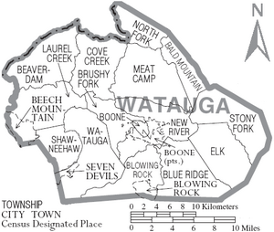
Townships
- Bald Mountain
- Beaverdam
- Blowing Rock
- Blue Ridge
- Boone
- Brushy Fork
- Cove Creek
- Elk
- Laurel Creek
- Meat Camp
- New River
- North Fork
- Shawneehaw
- Stony Fork
- Watauga
See also
 In Spanish: Condado de Watauga para niños


