Wall, South Dakota facts for kids
Quick facts for kids
Wall, South Dakota
Makȟóšiča Aglágla Otȟuŋwahe
|
|
|---|---|
 |
|

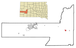
Location in Pennington County and the state of South Dakota
|
|
| Country | United States |
| State | South Dakota |
| County | Pennington |
| Incorporated | 1908 |
| Area | |
| • Total | 2.71 sq mi (7.02 km2) |
| • Land | 2.63 sq mi (6.81 km2) |
| • Water | 0.08 sq mi (0.21 km2) |
| Elevation | 2,815 ft (858 m) |
| Population
(2020)
|
|
| • Total | 699 |
| • Density | 265.78/sq mi (102.62/km2) |
| Time zone | UTC−7 (Mountain (MST)) |
| • Summer (DST) | UTC−6 (MDT) |
| ZIP code |
57790
|
| Area code(s) | 605 |
| FIPS code | 46-68380 |
| GNIS feature ID | 1267622 |
| Website | Wall, SD |
Wall (Lakota: Makȟóšiča Aglágla Otȟuŋwahe, "Town alongside the Badlands") is a town in Pennington County, South Dakota, United States. The population was 699 at the 2020 census.
History
Wall was platted in 1907 when the Chicago and North Western Railroad was extended to that point. The town was incorporated in 1908. Wall was named for the "natural wall" in rock formations by the Badlands National Park.
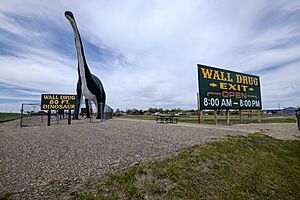
The town is most famous for the Wall Drug Store, which opened as a small pharmacy in 1931 during the Depression, but eventually developed into a large roadside tourist attraction.
The National Grasslands Visitor Center is also located in Wall.
Geography
According to the United States Census Bureau, the town has a total area of 2.22 square miles (5.75 km2), of which 2.17 square miles (5.62 km2) is land and 0.05 square miles (0.13 km2) is water.
The town is located on the eastern side of Pennington County across the Cheyenne River, thus being the largest settlement in the area.
Demographics
| Historical population | |||
|---|---|---|---|
| Census | Pop. | %± | |
| 1910 | 167 | — | |
| 1920 | 224 | 34.1% | |
| 1930 | 326 | 45.5% | |
| 1940 | 500 | 53.4% | |
| 1950 | 556 | 11.2% | |
| 1960 | 629 | 13.1% | |
| 1970 | 786 | 25.0% | |
| 1980 | 770 | −2.0% | |
| 1990 | 834 | 8.3% | |
| 2000 | 818 | −1.9% | |
| 2010 | 766 | −6.4% | |
| 2020 | 699 | −8.7% | |
| U.S. Decennial Census | |||
2010 census
At the 2010 census there were 766 people, 359 households, and 212 families in the town. The population density was 353.0 inhabitants per square mile (136.3/km2). There were 436 housing units at an average density of 200.9 per square mile (77.6/km2). The racial makeup of the town was 88.9% White, 0.1% African American, 7.0% Native American, 0.1% Asian, and 3.8% from two or more races. Hispanic or Latino of any race were 1.0%.
Of the 359 households 21.7% had children under the age of 18 living with them, 49.6% were married couples living together, 4.5% had a female householder with no husband present, 5.0% had a male householder with no wife present, and 40.9% were non-families. 39.6% of households were one person and 18.1% were one person aged 65 or older. The average household size was 2.13 and the average family size was 2.82.
The median age in the town was 47.1 years. 21.4% of residents were under the age of 18; 7.4% were between the ages of 18 and 24; 19.7% were from 25 to 44; 31.8% were from 45 to 64; and 19.6% were 65 or older. The gender makeup of the town was 50.4% male and 49.6% female.
Transportation
The Wall Municipal Airport is a general aviation airport located less than a mile northwest of Wall. The airport is owned by the City of Wall.
Intercity bus service to the city is provided by Jefferson Lines.
Education
The school district is Wall School District 51-5.
See also
 In Spanish: Wall (Dakota del Sur) para niños


