Walker County, Georgia facts for kids
Quick facts for kids
Walker County
|
||
|---|---|---|

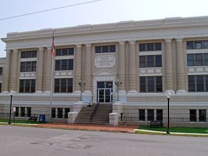
Walker County Courthouse in LaFayette
|
||
|
||

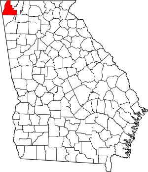
Location within the U.S. state of Georgia
|
||
 Georgia's location within the U.S. |
||
| Country | ||
| State | ||
| Founded | December 18, 1833 | |
| Named for | Freeman Walker | |
| Seat | LaFayette | |
| Largest city | LaFayette | |
| Area | ||
| • Total | 447 sq mi (1,160 km2) | |
| • Land | 446 sq mi (1,160 km2) | |
| • Water | 0.6 sq mi (2 km2) 0.1%% | |
| Population
(2020)
|
||
| • Total | 67,654 | |
| • Estimate
(2023)
|
69,489 |
|
| • Density | 151.35/sq mi (58.44/km2) | |
| Time zone | UTC−5 (Eastern) | |
| • Summer (DST) | UTC−4 (EDT) | |
| Congressional district | 14th | |
Walker County is a county in the Northwest region of the U.S. state of Georgia. As of the 2020 census, the population was 67,654, down from 68,756 in 2010. The county seat is LaFayette. The county was created on December 18, 1833, from land formerly belonging to the Cherokee Indian Nation. Walker County is part of the Chattanooga TN/GA Metropolitan Statistical Area.
Contents
History
Walker County was named after Georgia's U.S. Senator, Freeman Walker (1780–1827).
Civil War battles fought in Walker County were part of the Chickamauga Campaign fought between August 21 and September 20, 1863:
- Second Battle of Chattanooga, August 21.
- Battle of Davis's Cross Roads, September 10–11.
- Battle of Chickamauga, September 19–20.
In 2002 the Tri-State Crematory scandal in Noble came to national attention when 339 bodies that were consigned to be cremated were discovered on the property. The owner, Ray Brent Marsh, was convicted of several charges and sentenced to twelve years in prison.
Geography
According to the U.S. Census Bureau, the county has a total area of 447 square miles (1,160 km2), of which 446 square miles (1,160 km2) is land and 0.6 square miles (1.6 km2) (0.1%) is water. The northern two-thirds of Walker County is located in the Middle Tennessee-Chickamauga sub-basin of the Middle Tennessee-Hiwassee basin. Most of the southeastern portion of the county is located in the Oostanaula River sub-basin in the ACT River Basin (Coosa-Tallapoosa River Basin), with a very small southeastern sliver located in the Conasauga River sub-basin in the larger ACT River Basin. The rest of the southern portion of Walker County is located in the Upper Coosa River sub-basin in the ACT River Basin.
Adjacent counties
- Hamilton County, Tennessee - north
- Catoosa County - northeast
- Whitfield County - east
- Gordon County - southeast
- Floyd County - south
- Chattooga County - south
- DeKalb County, Alabama - southwest/CST Border
- Dade County - west
Natural attractions and features
- Chattahoochee National Forest (part)
- Chickamauga and Chattanooga National Military Park (part)
- Ellison's Cave (12th deepest cave in the United States)
- Lookout Mountain (part)
- McLemore Cove
- Petty John's Cave
- Pigeon Mountain
- Rocktown
- Rock City
- Lula Lake Land Trust
Transportation
Major highways
 U.S. Route 27
 U.S. Route 27 Business
 State Route 1
 State Route 1 Business
 State Route 2
 State Route 95
 State Route 136
 State Route 151
 State Route 157
 State Route 189
 State Route 193
 State Route 201
 State Route 337
 State Route 341
Railroads
Current
- Chattooga and Chickamauga Railway
- Tennessee Valley Railroad Museum (occasional tourist excursions)
Defunct
- Chattanooga Southern Railway (became Tennessee, Alabama and Georgia Railway)
- Tennessee, Alabama and Georgia Railway (merged into Southern Railway, then abandoned )
- Chickamauga and Durham Railroad (merged into Chattanooga & Durham)
- Chattanooga and Durham Railroad (merged by Chattanooga, Rome and Southern)
- Chattanooga, Rome and Southern Railroad (merged into Central of GA Railway)
- Central of Georgia Railway (merged into Southern Railway)
- Southern Railway (merged into Norfolk Southern, Walker County line transferred to State of Georgia, leased to Chattooga and Chickamauga Railway)
Demographics
| Historical population | |||
|---|---|---|---|
| Census | Pop. | %± | |
| 1840 | 6,572 | — | |
| 1850 | 13,109 | 99.5% | |
| 1860 | 10,082 | −23.1% | |
| 1870 | 9,925 | −1.6% | |
| 1880 | 11,056 | 11.4% | |
| 1890 | 13,282 | 20.1% | |
| 1900 | 15,661 | 17.9% | |
| 1910 | 18,692 | 19.4% | |
| 1920 | 23,370 | 25.0% | |
| 1930 | 26,206 | 12.1% | |
| 1940 | 31,024 | 18.4% | |
| 1950 | 38,198 | 23.1% | |
| 1960 | 45,264 | 18.5% | |
| 1970 | 50,691 | 12.0% | |
| 1980 | 56,470 | 11.4% | |
| 1990 | 58,340 | 3.3% | |
| 2000 | 61,053 | 4.7% | |
| 2010 | 68,756 | 12.6% | |
| 2020 | 67,654 | −1.6% | |
| 2023 (est.) | 69,489 | 1.1% | |
| U.S. Decennial Census 1790-1880 1890-1910 1920-1930 1930-1940 1940-1950 1960-1980 1980-2000 2010 2020 |
|||
2020 census
| Race / Ethnicity (NH = Non-Hispanic) | Pop 2000 | Pop 2010 | Pop 2020 | % 2000 | % 2010 | % 2020 |
|---|---|---|---|---|---|---|
| White alone (NH) | 57,336 | 63,343 | 59,654 | 93.91% | 92.13% | 88.18% |
| Black or African American alone (NH) | 2,300 | 2,809 | 2,840 | 3.77% | 4.09% | 4.20% |
| Native American or Alaska Native alone (NH) | 172 | 170 | 149 | 0.28% | 0.25% | 0.22% |
| Asian alone (NH) | 165 | 291 | 293 | 0.27% | 0.42% | 0.43% |
| Pacific Islander alone (NH) | 13 | 30 | 25 | 0.02% | 0.04% | 0.04% |
| Other race alone (NH) | 48 | 53 | 204 | 0.08% | 0.08% | 0.30% |
| Mixed race or Multiracial (NH) | 454 | 947 | 2,804 | 0.74% | 1.38% | 4.14% |
| Hispanic or Latino (any race) | 565 | 1,113 | 1,685 | 0.93% | 1.62% | 2.49% |
| Total | 61,053 | 68,756 | 67,654 | 100.00% | 100.00% | 100.00% |
As of the 2020 United States census, there were 67,654 people, 26,760 households, and 17,810 families residing in the county.
2010 census
As of the 2010 United States census, there were 68,756 people, 26,497 households, and 18,898 families living in the county. The population density was 154.0 inhabitants per square mile (59.5/km2). There were 30,100 housing units at an average density of 67.4 per square mile (26.0/km2). The racial makeup of the county was 93.0% white, 4.1% black or African American, 0.4% Asian, 0.3% American Indian, 0.6% from other races, and 1.6% from two or more races. Those of Hispanic or Latino origin made up 1.6% of the population. In terms of ancestry, 25.9% were American, 15.3% were Irish, 11.2% were English, and 9.3% were German.
Of the 26,497 households, 33.8% had children under the age of 18 living with them, 53.1% were married couples living together, 13.1% had a female householder with no husband present, 28.7% were non-families, and 24.7% of all households were made up of individuals. The average household size was 2.54 and the average family size was 3.01. The median age was 39.7 years.
The county's population age groups were spread out, with 23.6% under the age of 18, 5.3% from 20 to 24, 25.8% from 25 to 44, 27.8% from 45 to 64, and 15% who were 65 years of age or older. The gender ratio of the county's population was 50.9% female versus 49.1% male.
The median income for a household in the county was $38,723 and the median income for a family was $46,307. Males had a median income of $38,297 versus $29,285 for females. The per capita income for the county was $19,440. About 11.6% of families and 15.1% of the population were below the poverty line, including 20.0% of those under age 18 and 8.1% of those age 65 or over.
Communities
Cities
- Chickamauga
- Fort Oglethorpe (small portion only)
- LaFayette (county seat)
- Lookout Mountain
- Rossville
Census-designated places
Unincorporated communities
Media
- Walker County Messenger
Education
Walker County School District includes most areas, while areas in the Chickamauga city limits are in the Chickamauga City School District.
See also
 In Spanish: Condado de Walker (Georgia) para niños


