Wahianoa River facts for kids
Quick facts for kids Wahianoa River |
|
|---|---|
 |
|
| Native name | Wahianoa |
| Country | New Zealand |
| Region | Manawatū-Whanganui |
| District | Ruapehu District] |
| Physical characteristics | |
| Main source | Wahianoa Glacier Mount Ruapehu 2,300 m (7,500 ft) 39°17′42″S 175°34′34″E / 39.29500°S 175.57611°E |
| River mouth | Whangaehu River 740 m (2,430 ft) 39°26′34″S 175°37′35″E / 39.442892°S 175.626397°E |
| Length | 21 km (13 mi) |
| Basin features | |
| Progression | Wahianoa River → Whangaehu River |
| River system | Whangaehu River |
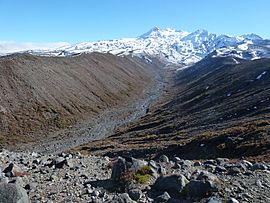
The Wahianoa River is a river of the Manawatū-Whanganui region of New Zealand's North Island. One of the headwaters of the Whangaehu River, it flows southeast from the southern slopes of Mount Ruapehu, gradually veering southwest before meeting the Whangaehu 3 kilometres (2 mi) northwest of Waiouru.

All content from Kiddle encyclopedia articles (including the article images and facts) can be freely used under Attribution-ShareAlike license, unless stated otherwise. Cite this article:
Wahianoa River Facts for Kids. Kiddle Encyclopedia.

