Vernon, Florida facts for kids
Quick facts for kids
Vernon, Florida
|
|
|---|---|
| City of Vernon | |

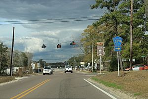
Florida State Road 79 in Vernon
|
|

Location in Washington County and the state of Florida
|
|
| Country | |
| State | |
| County | Washington |
| Incorporated | 1926 |
| Government | |
| • Type | Mayor-Council |
| Area | |
| • Total | 4.77 sq mi (12.35 km2) |
| • Land | 4.76 sq mi (12.34 km2) |
| • Water | 0.00 sq mi (0.01 km2) |
| Elevation | 43 ft (13 m) |
| Population
(2020)
|
|
| • Total | 732 |
| • Density | 153.65/sq mi (59.33/km2) |
| Time zone | UTC-6 (Central (CST)) |
| • Summer (DST) | UTC-5 (CDT) |
| ZIP code |
32462
|
| Area code(s) | 850 |
| FIPS code | 12-74125 |
| GNIS feature ID | 0292758 |
Vernon is a city in Washington County, Florida. The population was 732 at the 2020 census, up from 687 at the 2010 census. It is part of the Panama City—Panama City Beach, Florida Metropolitan Statistical Area.
History
The city sits on the Holmes Creek where during the 1880s the creek was used as a shipping route to Bonifay and other nearby towns. The creek was also used to ship gopher tortoises due to the high value their shell carried at that time. The town gained infamy in the late 1950s and early 1960s due to the improbably high percentage of residents who put out insurance claims on lost limbs, to the point that many speculated that residents of the town were intentionally dismembering themselves for the insurance money. Although there is no real evidence to support these speculations, these insurance claims from Vernon, with a population of 500–800, accounted for as many as 2/3 of claims nationally. The town was referred to as "Nub City".
Geography
Vernon is located at 30°37′18″N 85°42′42″W / 30.62167°N 85.71167°W (30.621699, -85.711628).
According to the United States Census Bureau, the city has a total area of 4.7 square miles (12 km2), all land.
Climate
The climate in this area is characterized by hot, humid summers and generally mild winters. According to the Köppen climate classification, the City of Vernon has a humid subtropical climate zone (Cfa).
Demographics
| Historical population | |||
|---|---|---|---|
| Census | Pop. | %± | |
| 1900 | 141 | — | |
| 1930 | 331 | — | |
| 1940 | 539 | 62.8% | |
| 1950 | 610 | 13.2% | |
| 1960 | 624 | 2.3% | |
| 1970 | 691 | 10.7% | |
| 1980 | 885 | 28.1% | |
| 1990 | 778 | −12.1% | |
| 2000 | 743 | −4.5% | |
| 2010 | 687 | −7.5% | |
| 2020 | 732 | 6.6% | |
| U.S. Decennial Census | |||
2010 and 2020 census
| Race | Pop 2010 | Pop 2020 | % 2010 | % 2020 |
|---|---|---|---|---|
| White (NH) | 524 | 523 | 76.27% | 71.45% |
| Black or African American (NH) | 96 | 101 | 13.97% | 13.80% |
| Native American or Alaska Native (NH) | 24 | 22 | 3.49% | 3.01% |
| Asian (NH) | 2 | 3 | 0.29% | 0.41% |
| Pacific Islander or Native Hawaiian (NH) | 1 | 1 | 0.15% | 0.14% |
| Some other race (NH) | 1 | 7 | 0.15% | 0.96% |
| Two or more races/Multiracial (NH) | 12 | 46 | 1.75% | 6.28% |
| Hispanic or Latino (any race) | 27 | 29 | 3.93% | 3.96% |
| Total | 687 | 732 |
As of the 2020 United States census, there were 732 people, 288 households, and 163 families residing in the city.
As of the 2010 United States census, there were 687 people, 462 households, and 306 families residing in the city.
Education
The following public schools within the city are operated by the Washington County School District:
- Vernon Elementary School
- Vernon Middle School
- Vernon High School
The district includes the entire county.
See also
 In Spanish: Vernon (Florida) para niños


