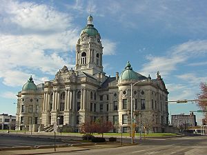
Vanderburgh County, Indiana facts for kids
Quick facts for kids
Vanderburgh County
|
||
|---|---|---|

|
||
|
||

Location within the U.S. state of Indiana
|
||
 Indiana's location within the U.S. |
||
| Country | ||
| State | ||
| Founded | January 7, 1818 | |
| Named for | Henry Vanderburgh | |
| Seat | Evansville | |
| Largest city | Evansville | |
| Area | ||
| • Total | 236.33 sq mi (612.1 km2) | |
| • Land | 233.48 sq mi (604.7 km2) | |
| • Water | 2.86 sq mi (7.4 km2) 1.21%% | |
| Population
(2020)
|
||
| • Total | 180,136 | |
| • Estimate
(2023)
|
179,810 |
|
| • Density | 762.222/sq mi (294.296/km2) | |
| Time zone | UTC−6 (Central) | |
| • Summer (DST) | UTC−5 (CDT) | |
| Congressional district | 8th | |
|
||
Vanderburgh County is a county in the U.S. state of Indiana. As of 2020, the population was 180,136. The county seat is in Evansville. While Vanderburgh County was the eighth-largest county in 2020 population in Indiana, it is also the eighth-smallest county in area and the smallest in southwestern Indiana, covering only 236 square miles (610 km2). Vanderburgh County forms the core of the Evansville metropolitan statistical area.
Contents
History
Vanderburgh County was formed on January 7, 1818, from Gibson, Posey, and Warrick counties. It was named for Captain Henry Vanderburgh, Revolutionary War veteran and judge for the Indiana Territory.
Geography
According to the 2010 census, the county has an area of 236.33 square miles (612.1 km2), of which 233.48 square miles (604.7 km2) (or 98.79%) is land and 2.86 square miles (7.4 km2) (or 1.21%) is water.
Regional
- Illinois–Indiana–Kentucky tri-state area
- Southwestern Indiana
Adjacent counties
|
Cities and towns
Census-designated places
Unincorporated towns
|
|
Townships
(2000 population)
|
|
|
|
Major highways
|
|
Climate and weather
| Weather chart for Evansville, Indiana | |||||||||||||||||||||||||||||||||||||||||||||||
|---|---|---|---|---|---|---|---|---|---|---|---|---|---|---|---|---|---|---|---|---|---|---|---|---|---|---|---|---|---|---|---|---|---|---|---|---|---|---|---|---|---|---|---|---|---|---|---|
| J | F | M | A | M | J | J | A | S | O | N | D | ||||||||||||||||||||||||||||||||||||
|
3.1
42
25
|
3.3
48
29
|
4.5
59
37
|
4.5
70
46
|
4.8
79
55
|
4.2
87
64
|
4.1
91
69
|
3.1
90
67
|
3.2
83
60
|
3
72
48
|
4.3
58
39
|
3.7
46
29
|
||||||||||||||||||||||||||||||||||||
| temperatures in °F precipitation totals in inches source: The Weather Channel |
|||||||||||||||||||||||||||||||||||||||||||||||
|
Metric conversion
|
|||||||||||||||||||||||||||||||||||||||||||||||
In recent years, average temperatures in Evansville have ranged from a low of 25 °F (−4 °C) in January to a high of 91 °F (33 °C) in July, although a record low of −17 °F (−27 °C) was recorded in January 1985 and a record high of 109 °F (43 °C) was recorded in July 1954. Average monthly precipitation ranged from 2.96 inches (75 mm) in October to 4.78 inches (121 mm) in May.
Demographics
| Historical population | |||
|---|---|---|---|
| Census | Pop. | %± | |
| 1820 | 1,798 | — | |
| 1830 | 2,611 | 45.2% | |
| 1840 | 6,250 | 139.4% | |
| 1850 | 11,414 | 82.6% | |
| 1860 | 20,552 | 80.1% | |
| 1870 | 33,145 | 61.3% | |
| 1880 | 42,193 | 27.3% | |
| 1890 | 59,809 | 41.8% | |
| 1900 | 71,769 | 20.0% | |
| 1910 | 77,438 | 7.9% | |
| 1920 | 92,293 | 19.2% | |
| 1930 | 113,320 | 22.8% | |
| 1940 | 130,783 | 15.4% | |
| 1950 | 160,422 | 22.7% | |
| 1960 | 165,794 | 3.3% | |
| 1970 | 168,772 | 1.8% | |
| 1980 | 167,515 | −0.7% | |
| 1990 | 165,058 | −1.5% | |
| 2000 | 171,922 | 4.2% | |
| 2010 | 179,703 | 4.5% | |
| 2020 | 180,136 | 0.2% | |
| 2023 (est.) | 179,810 | 0.1% | |
| U.S. Decennial Census 1790–1960 1900–1990 1990–2000 2010 |
|||
As of the 2010 United States census, there were 179,703 people, 74,454 households, and 45,118 families residing in the county. The population density was 769.7 inhabitants per square mile (297.2/km2). There were 83,003 housing units at an average density of 355.5 per square mile (137.3/km2). The racial makeup of the county was 86.2% white, 9.1% black or African American, 1.1% Asian, 0.2% American Indian, 0.1% Pacific islander, 1.0% from other races, and 2.3% from two or more races. Those of Hispanic or Latino origin made up 2.2% of the population. In terms of ancestry, 32.3% were German, 18.3% were American, 11.7% were Irish, and 9.4% were English.
Of the 74,454 households, 28.9% had children under the age of 18 living with them, 42.9% were married couples living together, 13.1% had a female householder with no husband present, 39.4% were non-families, and 32.3% of all households were made up of individuals. The average household size was 2.31 and the average family size was 2.93. The median age was 37.5 years.
The median income for a household in the county was $47,697 and the median income for a family was $57,076. Males had a median income of $42,663 versus $31,037 for females. The per capita income for the county was $23,945. About 10.7% of families and 15.6% of the population were below the poverty line, including 22.4% of those under age 18 and 7.7% of those age 65 or over.
Education
The entire county is in the Evansville-Vanderburgh School Corporation.
See also
 In Spanish: Condado de Vanderburgh para niños


