Tyrone, Colorado facts for kids
Quick facts for kids
Tyrone, Colorado
|
|
|---|---|

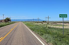
Tyrone, looking southwest along U.S. Route 350, with Raton Mesa in the distance
|
|
| Country | |
| State | |
| County | Las Animas County |
| Elevation | 5,541 ft (1,689 m) |
| Time zone | UTC-7 (MST) |
| • Summer (DST) | UTC-6 (MDT) |
| ZIP code |
81059 (Model)
|
| Area code(s) | 719 |
| GNIS feature ID | 0204807 |
Tyrone is an unincorporated community located in Las Animas County, Colorado, United States. The U.S. Post Office at Model (ZIP Code 81059) now serves Tyrone postal addresses.
A post office called Tyrone was established in 1929, and remained in operation until 1968. The origin of the name Tyrone is obscure.
Geography
Tyrone is located at 37°27′15″N 104°12′15″W / 37.45417°N 104.20417°W (37.454284,-104.204121).

All content from Kiddle encyclopedia articles (including the article images and facts) can be freely used under Attribution-ShareAlike license, unless stated otherwise. Cite this article:
Tyrone, Colorado Facts for Kids. Kiddle Encyclopedia.


