Twenty, Lincolnshire facts for kids
Quick facts for kids Twenty |
|
|---|---|
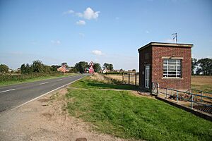
 The Village Hall, Twenty |
|
| OS grid reference | TF153207 |
| • London | 90 mi (140 km) S |
| District |
|
| Shire county | |
| Region | |
| Country | England |
| Sovereign state | United Kingdom |
| Post town | BOURNE |
| Postcode district | PE10 |
| Dialling code | 01778 |
| Police | Lincolnshire |
| Fire | Lincolnshire |
| Ambulance | East Midlands |
| EU Parliament | East Midlands |
Twenty is a village in the South Kesteven district of Lincolnshire, England. It is situated approximately 3 miles (5 km) east of Bourne, and 5 miles (8 km) west of Spalding.
Location
Twenty is situated on the A151 road, possibly originally a Roman road or Norman causeway, a road today notable for the very deep drainage dyke that runs alongside it. Nearby are Guthram Gowt and West Pinchbeck. Immediately to the south is the River Glen.
No separate population statistic is available for Twenty. The best available report lumps together Dyke, Twenty, South Fen and Spalding Road outside Bourne, with a total of 495, with Dyke being the largest.
Modern drainage
The area falls within the drainage area of the Black Sluice Internal Drainage Board. They maintain a small electric pumping station to the west of the crossroads, called Twenty Pumping Station


