Tungurahua facts for kids
Quick facts for kids Tungurahua |
|
|---|---|

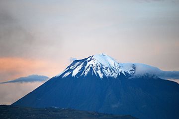
View from Riobamba (September 2011)
|
|
| Highest point | |
| Elevation | 5,023 m (16,480 ft) |
| Prominence | 1,554 m (5,098 ft) |
| Listing | Ultra |
| Naming | |
| English translation | Throat of fire |
| Language of name | Quechua |
| Geography | |
| Location | Ecuador |
| Parent range | Cordillera Oriental, Andes |
| Topo map | IGM, CT-ÑIV-D1 |
| Geology | |
| Age of rock | Holocene (Gomez 1994) |
| Mountain type | Stratovolcano (active) |
| Volcanic arc/belt | Northern Volcanic Zone |
| Last eruption | 2000 to 2018 (ongoing) |
| Climbing | |
| First ascent | 1873 by Alphons Stübel and Wilhelm Reiss |
| Easiest route | Scrambling/Snow/Ice PD |
Tungurahua, ( from Quichua tunguri (throat) and rahua (fire), "Throat of Fire") is an active stratovolcano located in the Cordillera Oriental of Ecuador. The volcano gives its name to the province of Tungurahua.
Volcanic activity restarted on August 19, 1999, and is ongoing as of 2013[update], with several major eruptions since then, the last starting on 1 February 2014.
Images for kids
-
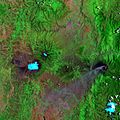
False-color satellite image of Tungurahua (center right, with plume of ash emanating from it) and its neighbor Chimborazo (center left)
See also
 In Spanish: Volcán Tungurahua para niños

All content from Kiddle encyclopedia articles (including the article images and facts) can be freely used under Attribution-ShareAlike license, unless stated otherwise. Cite this article:
Tungurahua Facts for Kids. Kiddle Encyclopedia.

