Troy, North Carolina facts for kids
Quick facts for kids
Troy, North Carolina
|
||
|---|---|---|

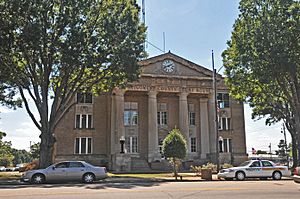
Montgomery County Courthouse
|
||
|
||
| Motto(s):
"Gateway to the Uwharries"
|
||

Location of Troy, North Carolina.
|
||
| Country | United States | |
| State | North Carolina | |
| County | Montgomery | |
| Area | ||
| • Total | 3.70 sq mi (9.59 km2) | |
| • Land | 3.66 sq mi (9.48 km2) | |
| • Water | 0.04 sq mi (0.11 km2) | |
| Elevation | 623 ft (190 m) | |
| Population
(2020)
|
||
| • Total | 2,850 | |
| • Density | 778.69/sq mi (300.68/km2) | |
| Time zone | UTC-5 (Eastern (EST)) | |
| • Summer (DST) | UTC-4 (EDT) | |
| ZIP code |
27371
|
|
| Area codes | 910, 472 | |
| FIPS code | 37-68520 | |
| GNIS feature ID | 2406760 | |
Troy is a town in Montgomery County, North Carolina, United States. The population was 3,188 at the 2010 census. It is the county seat of Montgomery County. A short story by Charles W. Chesnutt, The Sheriff's Children, is set in Troy.
History
Troy lies in an area once known for its vast longleaf pine forests; much of the town's early development came from the harvesting of those trees for lumber and turpentine. Originally known as West Old Fields, the name was changed to Troy in 1843 when the county seat of Montgomery County was moved there from Old Lawrenceville. The town was incorporated in 1853.
The coming of the Asheboro and Aberdeen railroad as well as the gold mining industry surrounding the town accelerated growth in the late 19th century. By the 20th century textile mills and lumber mills were contributing heavily to Troy's economy.
The Hotel Troy, Montgomery County Courthouse, and Troy Residential Historic District are listed on the National Register of Historic Places.
Geography
According to the United States Census Bureau, the town has a total area of 3.0 square miles (7.8 km2), of which 3.0 square miles (7.8 km2) is land and 0.34% is water.
Troy, along with most of Montgomery County, lies within the Uwharrie National Forest.
Demographics
| Historical population | |||
|---|---|---|---|
| Census | Pop. | %± | |
| 1870 | 67 | — | |
| 1880 | 130 | 94.0% | |
| 1900 | 878 | — | |
| 1910 | 1,055 | 20.2% | |
| 1920 | 1,102 | 4.5% | |
| 1930 | 1,522 | 38.1% | |
| 1940 | 1,861 | 22.3% | |
| 1950 | 2,213 | 18.9% | |
| 1960 | 2,346 | 6.0% | |
| 1970 | 2,429 | 3.5% | |
| 1980 | 2,702 | 11.2% | |
| 1990 | 3,404 | 26.0% | |
| 2000 | 3,430 | 0.8% | |
| 2010 | 3,189 | −7.0% | |
| 2020 | 2,850 | −10.6% | |
| U.S. Decennial Census | |||
2020 census
| Race | Number | Percentage |
|---|---|---|
| White (non-Hispanic) | 1,375 | 48.25% |
| Black or African American (non-Hispanic) | 939 | 32.95% |
| Native American | 11 | 0.39% |
| Asian | 37 | 1.3% |
| Other/Mixed | 67 | 2.35% |
| Hispanic or Latino | 421 | 14.77% |
As of the 2020 United States census, there were 2,850 people, 1,099 households, and 547 families residing in the town.
2010 census
As of the census of 2010, there were 3,189 people, 1,115 households, and 704 families residing in the town. The population density was 1,156.8 inhabitants per square mile (446.6/km2). There were 1,209 housing units at an average density of 407.7 per square mile (157.4/km2). The racial makeup of the town was 58.9% White, 31.8% African American, 0.73% Native American, 1.0% Asian, 3.32% from other races, and 1.5% from two or more races. Hispanic or Latino of any race were 10.3% of the population.
There were 1,108 households, out of which 30.3% had children under the age of 18 living with them, 37.2% were married couples living together, 20.4% had a female householder with no husband present, and 36.9% were non-families. 34.6% of all households were made up of individuals, and 16.0% had someone living alone who was 65 years of age or older. The average household size was 2.38 and the average family size was 3.04.
In the town, the population was spread out, with 21.6% under the age of 18, 11.1% from 18 to 24, 35.0% from 25 to 44, 16.9% from 45 to 64, and 15.4% who were 65 years of age or older. The median age was 36.7 years. Male population makes up 37% with a median age of 34.1 years. The female population makes up 63% with a median age of 37.7 years.
The median income for a household in the town was $22,933, and the median income for a family was $33,984. Males had a median income of $29,500 versus $19,861 for females. The per capita income for the town was $11,420. About 20.9% of families and 24.8% of the population were below the poverty line, including 32.8% of those under age 18 and 26.1% of those age 65 or over. Of the 1,115 occupied housing units, 46.7% are owner-occupied housing units while 53.3% are renter-occupied housing units.
Education
- Montgomery Community College
- Montgomery County Central High School
- Montgomery Learning Academy
- Page Street Elementary
Notable person
- Henry F. Warner, United States Army soldier and recipient of the Medal of Honor for his actions in World War II
See also
 In Spanish: Troy (Carolina del Norte) para niños


