Trans-Israel Highway facts for kids
| כביש חוצה ישראל Kvish Ḥotze Yisra'el כביש יצחק רבין Kvish Yitzḥak Rabin |
|
| Cross Israel Highway Yitzhak Rabin Highway |
|
| Lua error in Module:Infobox_road/map at line 15: attempt to index field 'wikibase' (a nil value). | |
Quick facts for kids Route information |
|
|---|---|
| Length | 140 km (90 mi) |
| Major junctions | |
| South end | Ma'ahaz (Ma'ahaz Interchange) |
|
|
| North end | Ein Tut Interchange (Milek stream) |
| Location | |
| Major cities: | Be'er Sheva, Kiryat Gat, Ramla, Petah Tikva, Rosh HaAyin, Pardes Hanna-Karkur, Hadera, Yokne'am, Haifa, |
| Highway system | |
| Roads in Israel Highways |
|
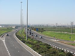
Trans-Israel Highway (also called Road 6/The Israel Turnpike, Hebrew: כביש 6, Kvish Shesh (Hebrew: כביש חוצה ישראל, Kvish Chotzeh Yisra'el) is a main highway crossing Israel from north to south. A control center and the headquarters of the road authority is located at Kessem Interchange near Rosh HaAyin.
Images for kids

All content from Kiddle encyclopedia articles (including the article images and facts) can be freely used under Attribution-ShareAlike license, unless stated otherwise. Cite this article:
Trans-Israel Highway Facts for Kids. Kiddle Encyclopedia.


