Tornillo, Texas facts for kids
Quick facts for kids
Tornillo, Texas
|
|
|---|---|
 |
|
| Country | |
| State | |
| County | El Paso |
| Area | |
| • Total | 3.4 sq mi (8.9 km2) |
| • Land | 3.4 sq mi (8.9 km2) |
| • Water | 0.0 sq mi (0.0 km2) |
| Elevation | 3,586 ft (1,093 m) |
| Population
(2020)
|
|
| • Total | 1,432 |
| • Density | 421/sq mi (160.9/km2) |
| Time zone | UTC-7 (Mountain (MST)) |
| • Summer (DST) | UTC-6 (MDT) |
| ZIP codes |
79838 & 79853
|
| Area code(s) | 915 |
| FIPS code | 48-73376 |
| GNIS feature ID | 2409336 |
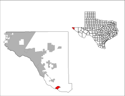
Tornillo (/tɔːrˈniːjoʊ/ tor-NEE-yoh) is a border town in El Paso County, Texas, United States. The population was 1,568 at the 2010 census. For statistical purposes, the United States Census Bureau has defined this unincorporated community as a census-designated place (CDP). It is part of the El Paso Metropolitan Statistical Area. The Tornillo and Guadalupe, Chihuahua, area is connected by the Tornillo–Guadalupe International Bridge.
The town is the home of Sonic Ranch, the world's largest residential recording complex.
In June 2018, the US government opened a tent city detention camp for migrant children at the Marcelino Serna Port of Entry on the Mexican border in Tornillo. By January 11, 2019, the last migrant child had been moved out of the camp en route to, or placed with, vetted sponsors.
Geography
According to the United States Census Bureau, the CDP has a total area of 3.4 square miles (8.8 km2), all land.
The city is located on State Highway 20 and the Southern Pacific Railroad.
Climate
According to the Köppen Climate Classification system, Tornillo has a semi-arid climate, abbreviated "BSk" on climate maps. Temperatures reach an average high of 96 °F and average low of 62 °F in June, and an average high of 59 °F and average low of 28 °F in December. The annual average rainfall is 9.25 inches.
| Climate data for Tornillo, Texas (1991–2020 normals, extremes 1981–present) | |||||||||||||
|---|---|---|---|---|---|---|---|---|---|---|---|---|---|
| Month | Jan | Feb | Mar | Apr | May | Jun | Jul | Aug | Sep | Oct | Nov | Dec | Year |
| Record high °F (°C) | 81 (27) |
88 (31) |
95 (35) |
98 (37) |
104 (40) |
111 (44) |
107 (42) |
106 (41) |
103 (39) |
97 (36) |
87 (31) |
79 (26) |
111 (44) |
| Mean daily maximum °F (°C) | 61.1 (16.2) |
67.1 (19.5) |
74.9 (23.8) |
82.5 (28.1) |
90.7 (32.6) |
97.7 (36.5) |
95.4 (35.2) |
93.8 (34.3) |
88.7 (31.5) |
80.9 (27.2) |
69.6 (20.9) |
60.1 (15.6) |
80.2 (26.8) |
| Daily mean °F (°C) | 44.9 (7.2) |
50.1 (10.1) |
57.2 (14.0) |
64.5 (18.1) |
72.2 (22.3) |
80.1 (26.7) |
81.1 (27.3) |
79.9 (26.6) |
73.9 (23.3) |
64.2 (17.9) |
52.4 (11.3) |
44.3 (6.8) |
63.7 (17.6) |
| Mean daily minimum °F (°C) | 28.8 (−1.8) |
33.1 (0.6) |
39.5 (4.2) |
46.5 (8.1) |
53.6 (12.0) |
62.6 (17.0) |
66.8 (19.3) |
65.9 (18.8) |
59.0 (15.0) |
47.5 (8.6) |
35.2 (1.8) |
28.5 (−1.9) |
47.3 (8.5) |
| Record low °F (°C) | 4 (−16) |
−1 (−18) |
13 (−11) |
27 (−3) |
35 (2) |
44 (7) |
53 (12) |
49 (9) |
41 (5) |
21 (−6) |
15 (−9) |
−2 (−19) |
−2 (−19) |
| Average precipitation inches (mm) | 0.36 (9.1) |
0.37 (9.4) |
0.25 (6.4) |
0.23 (5.8) |
0.50 (13) |
0.65 (17) |
1.68 (43) |
1.45 (37) |
1.12 (28) |
0.77 (20) |
0.36 (9.1) |
0.54 (14) |
8.28 (210) |
| Average snowfall inches (cm) | 0.4 (1.0) |
0.2 (0.51) |
0.0 (0.0) |
0.0 (0.0) |
0.0 (0.0) |
0.0 (0.0) |
0.0 (0.0) |
0.0 (0.0) |
0.0 (0.0) |
0.1 (0.25) |
0.3 (0.76) |
0.7 (1.8) |
1.7 (4.3) |
| Average precipitation days (≥ 0.01 in) | 3.0 | 3.1 | 1.9 | 1.4 | 2.4 | 3.4 | 6.7 | 6.3 | 4.5 | 3.7 | 2.1 | 3.1 | 41.6 |
| Average snowy days (≥ 0.1 in) | 0.2 | 0.0 | 0.0 | 0.0 | 0.0 | 0.0 | 0.0 | 0.0 | 0.0 | 0.0 | 0.0 | 0.3 | 0.5 |
| Source: NOAA | |||||||||||||
Demographics
| Historical population | |||
|---|---|---|---|
| Census | Pop. | %± | |
| 2020 | 1,432 | — | |
| U.S. Decennial Census 1850–1900 1910 1920 1930 1940 1950 1960 1970 1980 1990 2000 2010 |
|||
2020 census
| Race | Number | Percentage |
|---|---|---|
| White (NH) | 30 | 2.09% |
| Mixed/Multi-Racial (NH) | 4 | 0.28% |
| Hispanic or Latino | 1,398 | 97.63% |
| Total | 1,432 |
As of the 2020 United States census, there were 1,432 people, 337 households, and 281 families residing in the CDP.
Education
Almost all of Tornillo is served by the Tornillo Independent School District. A small portion lies within the Fabens Independent School District.
History
Tornillo was first platted in 1909 by a group of businessmen from El Paso, Texas who had formed the Tornillo Townsite Company. The first post office in the town opened the same year. Tornillo became the first agricultural area to be approved as part of the Rio Grande Irrigation Project after 1916. Cotton became the main crop in the region, however, by 1970, pecans were also a major agricultural crop in the area.
See also
 In Spanish: Tornillo (Texas) para niños


