Tophill Low facts for kids
| Site of Special Scientific Interest | |

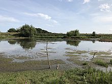
View from the North Lagoon hide at the Tophill Low nature reserve (taken 30 August 2018)
|
|
| Area of Search | East Riding of Yorkshire, North Yorkshire |
|---|---|
| Coordinates | 53°55′21″N 0°22′03″W / 53.922431°N 0.36757357°W |
| Interest | Biological |
| Area | 34.6225 hectares (85.554 acres) |
| Notification | 1989 |
Tophill Low is a nature reserve and Site of Special Scientific Interest (SSSI) in the East Riding of Yorkshire, England. The site is also an active water treatment works, operated by Yorkshire Water. It lies adjacent to the River Hull approximately 6 miles (9.7 km) south west of Driffield, and 3 miles (4.8 km) east of the village of Watton. The site, which was designated a SSSI in 1989, consists of two artificial reservoirs. The nature reserve extends further to a total area of 300 acres (120 hectares).
It is important as one of few inland standing open water bodies suitable for wintering wildfowl in the East Riding of Yorkshire. The reservoirs support nationally important numbers of gadwall, shoveler, and tufted duck. Also present are locally important numbers of goldeneye, great crested grebe, mallard, pochard, teal, and wigeon. The wider nature reserve comprises a variety of habitats with grassland, marshes, ponds, and woods supporting over 160 bird species across the year.

