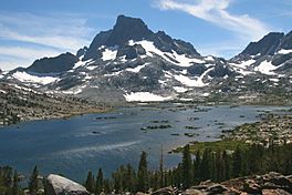
Thousand Island Lake facts for kids
Quick facts for kids Thousand Island Lake |
|
|---|---|

Banner Peak above the lake
|
|
| Location | Sierra Nevada, Ansel Adams Wilderness, Madera County, California, United States |
| Coordinates | 37°43′15″N 119°10′56″W / 37.72083°N 119.18222°W |
| Primary outflows | Middle Fork San Joaquin River |
| Basin countries | United States |
| Max. length | 2.5 mi (4.0 km) |
| Max. width | 0.7 mi (1.1 km) |
| Surface elevation | 2,997 metres (9,833 ft) |
| Islands | many |
Thousand Island Lake is a large alpine lake in the Sierra Nevada, within the Ansel Adams Wilderness in eastern Madera County, California.
The lake is named for the many small rocky islands that dot its surface. Theodore Solomons probably established the 'Thousand Island' name, as this appears on his 1896 map. John Muir called it by "Islet Lake."
Geography
The lake is within the boundaries of the Ansel Adams Wilderness of the Sierra National Forest and Inyo National Forest. Thousand Island Lake sits at the base of Banner Peak in the Ritter Range. It is the source of the Middle Fork of the San Joaquin River, which flows southeast, and then west, into the San Joaquin Valley. The lake is a glacial tarn, formed in the bottom of a cirque when a glacier retreated.
Access
Thousand Island Lake is accessible from several hiking routes:
- High Trail or River Trail: from Agnew Meadows trailhead (Inyo National Forest) - on road to Devils Postpile National Monument in Mammoth Lakes area
- John Muir Trail
- Pacific Crest Trail
- Sierra High Route
Culture
The black and white photographs by Ansel Adams made Thousand Island Lake a famous Sierra landmark.


