Thorhild County facts for kids
Quick facts for kids
Thorhild County
|
|
|---|---|

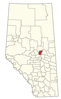
Location within Alberta
|
|
| Country | Canada |
| Province | Alberta |
| Region | Central Alberta |
| Census division | 13 |
| Established | 1955 |
| Incorporated | 1955 |
| Area
(2021)
|
|
| • Land | 1,997.17 km2 (771.11 sq mi) |
| Population
(2021)
|
|
| • Total | 3,042 |
| • Density | 1.5/km2 (4/sq mi) |
| Time zone | UTC−7 (MST) |
| • Summer (DST) | UTC−6 (MDT) |
| Area code(s) | 780 |
Thorhild County is a municipal district located in the central part of northern Alberta, Canada, in Census Division 13. It was incorporated in 1955. It changed its name from the County of Thorhild No. 7 to Thorhild County on March 20, 2013.
Geography
Communities and localities
|
The following urban municipalities are surrounded by Thorhild County.
The following hamlets are located within Thorhild County.
|
The following localities are located within Thorhild County.
|
Demographics
In the 2021 Census of Population conducted by Statistics Canada, Thorhild County had a population of 3,042 living in 1,339 of its 1,852 total private dwellings, a change of -6.5% from its 2016 population of 3,254. With a land area of 1,997.17 km2 (771.11 sq mi), it had a population density of 1.5/km2 (3.9/sq mi) in 2021.
In the 2016 Census of Population conducted by Statistics Canada, Thorhild County had a population of 3,254 living in 1,401 of its 1,836 total private dwellings, a -4.8% change from its 2011 population of 3,417. With a land area of 2,001.74 km2 (772.88 sq mi), it had a population density of 1.6/km2 (4.1/sq mi) in 2016.

