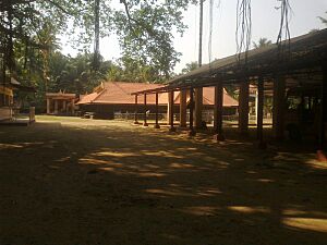
Thevalakkara facts for kids
Quick facts for kids
Thevalakkara
Deva Loka Kara ( Area of GODS)
|
|
|---|---|
|
Village
|
|

Thekkan Guruvayur Temple within the village
|
|
| Country | |
| State | Kerala |
| District | Kollam |
| Taluk | Karunagappally |
| Government | |
| • Type | Gram Panchayat |
| Area | |
| • Total | 16.92 km2 (6.53 sq mi) |
| Elevation | 10 m (30 ft) |
| Population
(2011)
|
|
| • Total | 42,977 |
| • Density | 2,540.0/km2 (6,578.6/sq mi) |
| Languages | |
| • Official | Malayalam, English |
| Time zone | UTC+5:30 (IST) |
| PIN |
690524
|
| STD code | 0476287 |
| Vehicle registration | KL-23 |
| Nearest city | Karunagappally |
| Lok Sabha constituency | Kollam |
| Vidhan Sabha constituency | Chavara |
Thevalakkara is a village in the Karunagappally Taluk, Kollam District of the state of Kerala, India. It is located near the coast of the Indian Ocean, about 13 kilometres north of the district capital Kollam, and 7 kilometres southeast of the subdistrict capital Karunagappally. It contains a Devi temple along with a church and a mosque. The kadappa at Thevalakara is where ship masts (kadappa) were made for centuries. In 2011, it has a total population of 42,977.
Geography
Thevalakkara is located on the northwestern shore of the Ashtamudi Lake. The National Highway 183A passes through the village. Its average elevation is 10 metres above the sea level.
Climate
Thevalakkara has a Tropical Monsoon Climate (Am). Its wettest month is June, with an average rainfall of 418 mm; and the driest month is January, with an average rainfall of 25 mm.
| Climate data for Thevalakkara | |||||||||||||
|---|---|---|---|---|---|---|---|---|---|---|---|---|---|
| Month | Jan | Feb | Mar | Apr | May | Jun | Jul | Aug | Sep | Oct | Nov | Dec | Year |
| Mean daily maximum °C (°F) | 30.9 (87.6) |
32 (90) |
32.2 (90.0) |
31.2 (88.2) |
29.9 (85.8) |
28.2 (82.8) |
27.8 (82.0) |
27.8 (82.0) |
28.3 (82.9) |
28.6 (83.5) |
28.9 (84.0) |
29.7 (85.5) |
29.6 (85.4) |
| Daily mean °C (°F) | 26.5 (79.7) |
27.3 (81.1) |
28 (82) |
27.9 (82.2) |
27.3 (81.1) |
26 (79) |
25.5 (77.9) |
25.5 (77.9) |
25.8 (78.4) |
25.9 (78.6) |
26 (79) |
26.2 (79.2) |
26.5 (79.7) |
| Mean daily minimum °C (°F) | 22.9 (73.2) |
23.5 (74.3) |
24.7 (76.5) |
25.4 (77.7) |
25.4 (77.7) |
24.6 (76.3) |
24.1 (75.4) |
24 (75) |
24.1 (75.4) |
24 (75) |
23.7 (74.7) |
23.3 (73.9) |
24.1 (75.4) |
| Average rainfall mm (inches) | 25 (1.0) |
30 (1.2) |
75 (3.0) |
167 (6.6) |
314 (12.4) |
418 (16.5) |
363 (14.3) |
294 (11.6) |
247 (9.7) |
267 (10.5) |
189 (7.4) |
65 (2.6) |
2,454 (96.8) |
| Source: Climate-Data.org | |||||||||||||
Demographics
According to the 2011 Indian Census, Thevalakara has a total of 10,473 households. Out of the 42,977 residents, 20,278 are male and 22,699 are female. The total literacy rate is 82.52%, with 16,960 of the male population and 18,506 of the female population being literate. The census location code of the village is 628361.
Notable personalities
- Thevalakkara Aliyarukunju Moulavi
- Babykuttan Thoolika


