Temburong District facts for kids
Quick facts for kids
Temburong
|
|
|---|---|
|
District
|
|
 |
|
| Capital | Bangar |
| Area | |
| • Total | 1,306 km2 (504 sq mi) |
| Population
(2016)
|
|
| • Total | 10,543 |
| • Density | 8.073/km2 (20.908/sq mi) |
| Website | http://temburong.gov.bn |
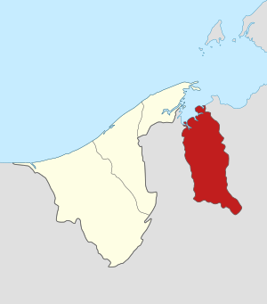
Temburong District is a district in Brunei. The capital city is Bangar.
Temburong is an exclave. It is separated from the rest of Brunei by Malaysia and Brunei Bay. The Temburong River flows through the district, and the Sungai Pandaruan river forms the western border. Brunei's first national park, the Ulu Temburong National Park, is in the south of the Temburong district.
Temburong is divided into five mukim (subdistricts):
- Amo
- Bangar
- Batu Apoi
- Bokok
- Labu
Images for kids
See also
 In Spanish: Distrito de Temburong para niños

All content from Kiddle encyclopedia articles (including the article images and facts) can be freely used under Attribution-ShareAlike license, unless stated otherwise. Cite this article:
Temburong District Facts for Kids. Kiddle Encyclopedia.

