Tecopa, California facts for kids
Quick facts for kids
Tecopa
|
|
|---|---|

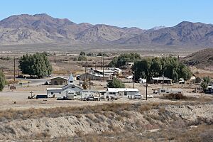
Tecopa from the southwest
|
|

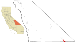
Location in Inyo County and the state of California
|
|
| Country | United States |
| State | California |
| County | Inyo |
| Area | |
| • Total | 18.657 sq mi (48.323 km2) |
| • Land | 18.589 sq mi (48.146 km2) |
| • Water | 0.068 sq mi (0.177 km2) 0.37% |
| Elevation | 1,545 ft (471 m) |
| Population
(2020)
|
|
| • Total | 120 |
| • Density | 6.43/sq mi (2.48/km2) |
| Time zone | UTC-8 (Pacific (PST)) |
| • Summer (DST) | UTC-7 (PDT) |
| ZIP code |
92389
|
| Area codes | 442/760 |
| FIPS code | 06-78050 |
| GNIS feature ID | 2410062 |

Tecopa is a census-designated place (CDP) in the Mojave Desert in southeast Inyo County, California, United States. Originally occupied by the Koso and Chemehuevi Indians, Pioneers began populating what would become the CDP in the late 19th century to support nearby mines. It is now better known for the natural hot springs in the northern part of the CDP.
Contents
Regional History
The Old Spanish Trail and the later wagon road called the Old Mormon Road or Salt Lake Road, passed from Resting Springs, east of the modern site of Tecopa, 7 miles to Willow Creek (fed by Willow Spring within China Ranch Wash on the east bank of the canyon of the Amargosa River (then called Saleratus Creek)), south of Tecopa.
There the trail turned to follow the river south to Salt Springs.
China Ranch Wash is named for the Chinese Man who developed Willow Creek around 1900 and raised meat and vegetables to sell to the miners.
History of the Community
Original Town
In 1875 two brothers William D. and Robert D. Brown, had discovered lead and silver ore at what would become the Resting Springs Mining District and began promoting it. They established a townsite, calling it Brownsville, 5 miles (8 km) southeast of Resting Springs near the head of Willow Creek. Kasson, California was nearby. A camp was established at the site as mines were developed at Noonday Mine in the late 1870s. Jonas Osborne bought out the Browns, and renamed the townsite after Paiute leader Chief Tecopa. The camp grew into a town; in 1877 a post office began operating at there.
In 1878, it was determined that the townsite was 300 yards within Inyo county. Settling a dispute with San Bernardino County of who controlled the township. Soon thereafter, the town went into decline, with most of the miners moving to Resting Springs in July 1879. Inyo County Sheriff William Welch considered Tecopa a costly mistake because, "it costs five cents a pound freight from San Bernardino here." The original townsite was occasionally occupied but never really revived and in 2006 the Amargosa Conservancy acquired it for preservation purposes
The townsite is currently located in the vicinity of "The Triangle", a small piece of land surrounded by the arms of three "Y's" at the intersection of two roads. It was reestablished in 1907 when the Tonopah and Tidewater Railroad reached the site, which was the closest point from the railroad to the mines. A post office opened at the new site in 1907, was closed in 1931, and reopened in 1932. A church, some homes and seasonal eating establishments are also located by the Triangle.
Hot Springs
The road heading north of the Triangle leads to the Hot Springs zone of the community where the State of California made indemnity selections in 1927. The State subsequently sold parcels to private citizens. In the early 1960s John Gregory Dunne documented that several low-income retirees were squatting in trailers within the zone.
The Bureau of Land Management (BLM) granted a 40 acre "Recreational and Public Purposes" (R&PP) lease to Inyo County for County run facilities. The Hot Springs area is currently where the Community Center, Fire Station, Library, several tourist facilities and some homes are located.
Tecopa Heights
The Triangle is the west endpoint of the Old Spanish Trail (OST) Heading east, the OST Road passes Tecopa-Francis Elementary School (now closed) to the intersection with the Furnace Creek Road. Southwest of the intersection is most populous part of the community, originally known as "Jackrabbit Flat." In the 1950', the General Land Office, then the BLM began offering parcels under the authority of the Small Tract Act of 1938 as recreational properties to become known as "Jackrabbit Homesteads. The first round of five acre parcels were proofed and patented prior to 1959. After a change in policy second round of a few more parcels were offered at fair market value by BLM. The lands offered under the first two rounds remain largely undeveloped. The third round of 2.5 acre parcels were offered in 1964 to provide inexpensive land for housing retirees that were squatting at the Hot Springs. Seven parcels were sold, six of which were purchased by the Thilenius and Parrish families who subdivided them and developed water systems. Those parcels now constitute the densist population of what is now known as "Tecopa Heights," the area offered under the Small Tracts Act. The cemetery is on the west side of Tecopa Heights.
Since Tecopa lacks proper water infrastructure that is capable of properly filtering ground water to state standards, the Southern Inyo County Fire Protection District in 2014 received a grant in order to install a water kiosk for the community, The community water kiosk was opened in 2017 east of Tecopa Heights on an R&PP lease granted by the BLM.
Geography
In 1976, Congress designated the federal lands within the CDP part of the "California Desert Conservation Area" in Title VI, Section 601 of the Federal Land Policy and Management Act of 1976. Tecopa is on the east side of the Amargosa Range which lies between the CDP and Death Valley, which was designated a National Park in the California Desert Protection Act of 1994 CDPA. The Nopah Range, designated Wilderness in the CDPA is to the east.
According to the United States Census Bureau, the CDP has a total area of 18.7 square miles (48 km2), of which, 18.6 square miles (48 km2) of it is land and 0.1 square miles (0.26 km2) of it (0.37%) is water.
Economy
Historically, Tecopa's economy was based on silver and lead mining.
A major attraction in the area is the Tecopa Ecological Reserve, which hosts an undeveloped natural ground-fed hot spring. However, the natural hot spring is subject to closure because of impacts to protected Amargosa vole (a subspecies of Microtus californicau) habitat from camp fires and human waste.
.....
The town has a growing microbrewery and bakery scene that caters to the patrons of Tecopa's three hot springs resorts during the fall and winter seasons.
Arts and culture
Tecopa holds an annual firehouse fling in November. It is hosted by Southern Inyo Fire Protection District, as a way to raise funds for the rural fire department
Tecopa also hosts in November Tecopa Takeover Music Festival since 2014
Demographics
2010
At the 2010 census Tecopa had a population of 150. The population density was 8.0 people per square mile (3.1/km2). The racial makeup of Tecopa was 119 (79.3%) White, 1 (0.7%) African American, 8 (5.3%) Native American, 2 (1.3%) Asian, 0 (0.0%) Pacific Islander, 1 (0.7%) from other races, and 19 (12.7%) from two or more races. Hispanic or Latino of any race were 8 people (5.3%).
The whole population lived in households, no one lived in non-institutionalized group quarters and no one was institutionalized.
There were 92 households, 13 (14.1%) had children under the age of 18 living in them, 22 (23.9%) were opposite-sex married couples living together, 2 (2.2%) had a female householder with no husband present, 6 (6.5%) had a male householder with no wife present. There were 6 (6.5%) unmarried opposite-sex partnerships, and 2 (2.2%) same-sex married couples or partnerships. 56 households (60.9%) were one person and 28 (30.4%) had someone living alone who was 65 or older. The average household size was 1.63. There were 30 families (32.6% of households); the average family size was 2.60.
The age distribution was 19 people (12.7%) under the age of 18, 5 people (3.3%) aged 18 to 24, 17 people (11.3%) aged 25 to 44, 59 people (39.3%) aged 45 to 64, and 50 people (33.3%) who were 65 or older. The median age was 57.5 years. For every 100 females, there were 138.1 males. For every 100 females age 18 and over, there were 133.9 males.
There were 159 housing units at an average density of 8.5 per square mile (3.3/km2),of which 92 were occupied, 57 (62.0%) by the owners and 35 (38.0%) by renters. The homeowner vacancy rate was 6.6%; the rental vacancy rate was 10.3%. 96 people (64.0% of the population) lived in owner-occupied housing units and 54 people (36.0%) lived in rental housing units.
2000
At the 2000 census there were 99 people, 60 households, and 22 families in the CDP. The population density was 5.3 people per square mile (2.1/km2). There were 133 housing units at an average density of 7.2 per square mile (2.8/km2). The racial makeup of the CDP was 88.89% White, 1.01% Black or African American, 7.07% Native American, and 3.03% from two or more races. 4.04% of the population were Hispanic or Latino of any race. Of the 60 households 10.0% had children under the age of 18 living with them, 28.3% were married couples living together, 6.7% had a female householder with no husband present, and 63.3% were non-families. 55.0% of households were one person and 30.0% were one person aged 65 or older. The average household size was 1.65 and the average family size was 2.50.
The age distribution was 10.1% under the age of 18, 4.0% from 18 to 24, 14.1% from 25 to 44, 28.3% from 45 to 64, and 43.4% 65 or older. The median age was 63 years. For every 100 females, there were 80.0 males. For every 100 females age 18 and over, there were 78.0 males.
The median household income was $12,344 and the median family income was $16,250. Males had a median income of $0 versus $31,250 for females. The per capita income for the CDP was $10,395. There were 30.8% of families and 38.6% of the population living below the poverty line, including 100.0% of under eighteens and 27.0% of those over 64.
Infrastructure
Transportation
Public transportation in Tecopa is operated by Eastern Sierra Transit Authority as a fixed route lifeline service to residents of Tecopa to Pahrump twice a month. In October 2020, service was suspended because the contractor serving this route, Pahrump Senior Center, sold the route to a third-party vendor and failed to meet contractual obligations. Eastern Sierra Transit Authority is in the process of finding an alternative provider for the Tecopa bus route
Utilities
Tecopa receives electrical power through Southern California Edison. There is no gas utility serving Tecopa. The community instead relies on propane gas deliveries from companies located in Pahrump
The Incumbent telephone carrier for Tecopa is AT&T. The county acknowledges that AT&T fails to maintain their network by providing unreliable Telephone and internet service. The community instead relies on Fixed Wireless Internet Service Providers and Satellite internet
Tecopa doesn't have traditional residential waste services. Instead, residents use communal dumpsters, which are serviced by C&S Waste Solutions under the Pahrump Valley Disposal brand.
See also
 In Spanish: Tecopa para niños


