Tea Table Key facts for kids

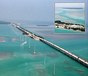
Aerial view of the causeway and bridge just southwest of Lower Matecumbe Key. Teatable Key is in the upper left. A short road from US-1 leads to a private area.
|
|
| Geography | |
|---|---|
| Location | Gulf of Mexico |
| Coordinates | 24°53′47″N 80°39′44″W / 24.896373°N 80.66219°W |
| Administration | |
| State | Florida |
| County | Monroe |
Tea Table Key also known as "Terra's Key" is an island in the upper Florida Keys.
It is located on U.S. 1 at mile marker 79.
All of the key is within the Villages of Islamorada as of November 4, 1997, when it was incorporated.
The island lies to the southwest of Upper Matecumbe Key, and to the northeast of Lower Matecumbe Key.
There is a small private beach on the island the entrance is to a private road that leads to a private residence.

All content from Kiddle encyclopedia articles (including the article images and facts) can be freely used under Attribution-ShareAlike license, unless stated otherwise. Cite this article:
Tea Table Key Facts for Kids. Kiddle Encyclopedia.


