Tate County, Mississippi facts for kids
Quick facts for kids
Tate County
|
|
|---|---|

Tate County Courthouse, 201 S. Ward St., Senatobia
|
|

Location within the U.S. state of Mississippi
|
|
 Mississippi's location within the U.S. |
|
| Country | |
| State | |
| Founded | 1873 |
| Seat | Senatobia |
| Largest city | Senatobia |
| Area | |
| • Total | 411 sq mi (1,060 km2) |
| • Land | 405 sq mi (1,050 km2) |
| • Water | 6.2 sq mi (16 km2) 1.5% |
| Population
(2010)
|
|
| • Total | 28,886 |
| • Estimate
(2018)
|
28,759 |
| • Density | 70.28/sq mi (27.14/km2) |
| Time zone | UTC−6 (Central) |
| • Summer (DST) | UTC−5 (CDT) |
| Congressional district | 1st |
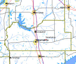
Tate County is a county located in the northwestern portion of the U.S. state of Mississippi. As of the 2010 census, the population was 28,886. Its county seat is Senatobia. Organized in 1873 during the Reconstruction era, from portions of DeSoto, Marshall, and Tunica counties, the county is named for Thomas Simpson Tate, one of the first prominent American settlers of the area.
Tate County is part of the Memphis, TN-MS-AR Metropolitan Statistical Area. It is located about 40 miles (64 km) south of Memphis and one county east of the Mississippi River. This fertile river valley was developed for cotton cultivation in the 19th century.
Contents
Geography
According to the U.S. Census Bureau, the county has a total area of 411 square miles (1,060 km2), of which 405 square miles (1,050 km2) is land and 6.2 square miles (16 km2) (1.5%) is water. It is the third-smallest county in Mississippi by land area.
Major highways
 Interstate 55
 U.S. Route 51
 Mississippi Highway 3
 Mississippi Highway 4
 Mississippi Scenic Highway 304
 Mississippi Highway 305
 Mississippi Highway 306
 Mississippi Highway 740
Adjacent counties
- DeSoto County (north)
- Marshall County (east)
- Lafayette County (southeast)
- Panola County (south)
- Tunica County (west)
Demographics
| Historical population | |||
|---|---|---|---|
| Census | Pop. | %± | |
| 1880 | 18,721 | — | |
| 1890 | 19,253 | 2.8% | |
| 1900 | 20,618 | 7.1% | |
| 1910 | 19,714 | −4.4% | |
| 1920 | 19,636 | −0.4% | |
| 1930 | 17,671 | −10.0% | |
| 1940 | 19,309 | 9.3% | |
| 1950 | 18,011 | −6.7% | |
| 1960 | 18,138 | 0.7% | |
| 1970 | 18,544 | 2.2% | |
| 1980 | 20,119 | 8.5% | |
| 1990 | 21,432 | 6.5% | |
| 2000 | 25,370 | 18.4% | |
| 2010 | 28,886 | 13.9% | |
| 2018 (est.) | 28,759 | −0.4% | |
| U.S. Decennial Census 1790-1960 1900-1990 1990-2000 2010-2013 |
|||
2020 census
| Race | Num. | Perc. |
|---|---|---|
| White | 18,019 | 64.21% |
| Black or African American | 8,231 | 29.33% |
| Native American | 52 | 0.19% |
| Asian | 63 | 0.22% |
| Pacific Islander | 1 | 0.0% |
| Other/Mixed | 893 | 3.18% |
| Hispanic or Latino | 805 | 2.87% |
As of the 2020 United States Census, there were 28,064 people, 10,324 households, and 7,580 families residing in the county.
Communities
City
- Senatobia (county seat)
Town
Unincorporated communities
Notable people
- Actor James Earl Jones was born in Arkabutla, Mississippi, an unincorporated area of Tate County and lived here for five years. He was sent north to live with his maternal grandparents on their farm in Jackson, Michigan.
See also
 In Spanish: Condado de Tate (Misisipi) para niños


