Taklamakan Desert facts for kids
Quick facts for kids Taklamakan Desert |
|
|---|---|

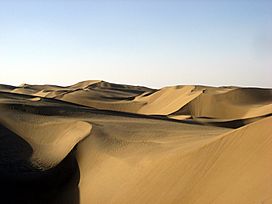
View of the Taklamakan desert
|
|

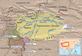
Taklamakan Desert and Tarim Basin
|
|
| Area | 337,000 km2 (130,000 sq mi) |
| Geography | |
| Country | China |
| State/Province | Xinjiang |
The Taklamakan Desert, also known as Taklimakan and Teklimakan, is a desert in northwest China, in the southwest part of the Xinjiang Uyghur Autonomous Region. It is bounded by the Kunlun Mountains to the south, and the desert Pamir Mountains and Tian Shan to the west and north. The Taklamakan Desert Ecoregion is a Chinese ecoregion of the Deserts and xeric shrublands Biome.
There is very little water in the desert and it is dangerous to cross. Merchant caravans on the Silk Road stopped for relief at the thriving oasis towns. The key oasis towns, watered by rainfall from the mountains, were Kashgar, Marin, Niya, Yarkand, and Khotan to the south, Kuqa and Turpan in the north, and Loulan and Dunhuang in the east. Some of these are now ruined cities in sparsely inhabited areas in the Xinjiang Autonomous Region. The present population consists largely of Turkic Uyghur people.
Images for kids
-
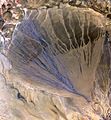
The Molcha (Moleqie) River forms a vast alluvial fan at the southern border of the Taklamakan Desert, as it leaves the Altyn-Tagh mountains and enters the desert in the western part of the Qiemo County. The left side appears blue from water flowing in many streams. The picture is taken in May, when the river is full with the snow/glacier meltwater.
See also
 In Spanish: Taklamakán para niños


