Sulu Sea facts for kids
Quick facts for kids Sulu Sea |
|
|---|---|

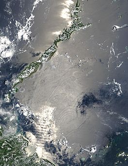
Satellite image from NASA showing the internal waves formed in the Sulu Sea
|
|
| Coordinates | 8°N 120°E / 8°N 120°E |
| Type | sea |
| Etymology | Sulu |
| Basin countries | |
| Surface area | 260,000 square kilometres (100,000 sq mi) |
| Settlements |
|
Sulu Sea has a number of islands. The Cuyo Islands and Cagayan Sulu are part of the province of Palawan while Mapun and the Turtle Islands are part of the province of Tawi-Tawi. The Tubbataha Reef National Marine Park, one of the World Heritage Sites, is in Sulu.
Images for kids
-
The sea as viewed from Palawan
See also
 In Spanish: Mar de Joló para niños

All content from Kiddle encyclopedia articles (including the article images and facts) can be freely used under Attribution-ShareAlike license, unless stated otherwise. Cite this article:
Sulu Sea Facts for Kids. Kiddle Encyclopedia.


