Sugarloaf Hill (Knockmealdowns) facts for kids
Quick facts for kids Sugarloaf Hill |
|
|---|---|
| Cnoc na Binne | |

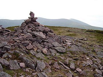
Summit cairn of Sugarloaf Hill
|
|
| Highest point | |
| Elevation | 663 m (2,175 ft) |
| Prominence | 118 m (387 ft) |
| Listing | Hewitt |
| Geography | |
|
Lua error in Module:Location_map at line 420: attempt to index field 'wikibase' (a nil value).
|
|
| Location | County Tipperary / County Waterford, Ireland |
| Parent range | Knockmealdown Mountains |
| OSI/OSNI grid | S039105 |
| Topo map | OSi Discovery 74 |
Sugarloaf Hill (Irish: Cnoc na Binne) is a mountain peak located in the Knockmealdown Mountains on the border between County Tipperary and County Waterford.

All content from Kiddle encyclopedia articles (including the article images and facts) can be freely used under Attribution-ShareAlike license, unless stated otherwise. Cite this article:
Sugarloaf Hill (Knockmealdowns) Facts for Kids. Kiddle Encyclopedia.