Sugarloaf Hill, Malvern facts for kids
Quick facts for kids Sugarloaf Hill |
|
|---|---|

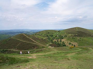
Sugarloaf Hill (left) with Table Hill and North Hill
|
|
| Highest point | |
| Elevation | 368 m (1,207 ft) |
| Prominence | 10m (33ft) |
| Parent peak | Table Hill |
| Geography | |
| Location | Malvern Hills, England |
| Topo map | OS Landranger 150 |
| Geology | |
| Age of rock | Pre-Cambrian |
| Mountain type | Igneous, Metamorphic |
| Climbing | |
| Easiest route | Hiking |
Sugarloaf Hill lies between the Worcestershire Beacon and North Hill in the range of Malvern Hills that runs about 13 kilometres (8 mi) north-south along the Herefordshire-Worcestershire border.
The summit of Sugarloaf Hill is 368 metres (1,207 ft) above sea level and is a popular peak usually passed by walkers hiking between the Worcestershire Beacon and North Hill—respectively the highest and second highest Malvern Hills summits.

All content from Kiddle encyclopedia articles (including the article images and facts) can be freely used under Attribution-ShareAlike license, unless stated otherwise. Cite this article:
Sugarloaf Hill, Malvern Facts for Kids. Kiddle Encyclopedia.