Stratford, Queensland facts for kids
Quick facts for kids StratfordCairns, Queensland |
|||||||||||||||
|---|---|---|---|---|---|---|---|---|---|---|---|---|---|---|---|

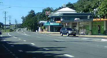
View of Stratford town along Kamerunga Road and Stratford Parade
|
|||||||||||||||
| Population | 1,198 (2021 census) | ||||||||||||||
| • Density | 631/km2 (1,630/sq mi) | ||||||||||||||
| Established | 1877 | ||||||||||||||
| Postcode(s) | 4870 | ||||||||||||||
| Elevation | 5 m (16 ft) | ||||||||||||||
| Area | 1.9 km2 (0.7 sq mi) | ||||||||||||||
| Time zone | AEST (UTC+10:00) | ||||||||||||||
| Location |
|
||||||||||||||
| LGA(s) | Cairns Region | ||||||||||||||
| County | Nares | ||||||||||||||
| State electorate(s) | Barron River | ||||||||||||||
| Federal Division(s) | Leichhardt | ||||||||||||||
|
|||||||||||||||
|
|||||||||||||||
Stratford is a suburb of Cairns in the Cairns Region, Queensland, Australia. In the 2021 census, Stratford had a population of 1,198 people.
Geography
Stratford is 6.8 kilometres (4.2 mi) NNW of the Cairns CBD. It is bounded to the north by the Barron River. It is bounded to the east by the Captain Cook Highway. The northern part of the suburb is situated on the lower slopes (10–40 metres above sea level) of Mount Whitfield and Lumley Hill and is used for residential housing. The southern part of the suburb is undeveloped dense bushland on the higher slopes rising to about 160 metres.
History
In the 2006 census, Stratford had a population of 1,178 people.
Demographics
In the 2006 census, Stratford had a population of 1,178 people.
In the 2011 census, Stratford had a population of 1,109 people.
In the 2016 census, Stratford had a population of 1,138 people.
In the 2021 census, Stratford had a population of 1,198 people.
Heritage listings
Stratford has a number of heritage-listed sites, including:
- Magazine Street (16°52′28″S 145°44′15″E / 16.8744°S 145.7374°E): former Explosives Magazine and Detonator Store
In 2009 for the Q150 commemorations, the Stratford and Freshwater Community Association built a heritage trail, with 29 signposted sites in Stratford and 22 signposted sites in the neighbouring suburb of Freshwater, Queensland.
Amenities
Cairns Regional Council operate a public library at 11 Kamerunga Road (16°52′32″S 145°43′58″E / 16.8756°S 145.7327°E).
Stratford Community Hall is at 15 Kamerunga Road (adjacent to the library, 16°52′33″S 145°43′57″E / 16.87584°S 145.73242°E). It is capable of seating up to 50 people and is operated by the Stratford & Freshwater Community Association.
St Augustine's Catholic Church is at 23 Kamerunga Road (16°52′33″S 145°43′53″E / 16.8757°S 145.7315°E). It is within the Northern Beaches Parish of the Roman Catholic Diocese of Cairns.
There is a boat ramp and floating walking at Greenbank West Road on the south bank of Barron River adjacent to the William Walter Mason Bridge (16°52′12″S 145°44′12″E / 16.8699°S 145.7366°E). It is managed by the Cairns Regional Council.


